Fish
Fish Fire
Fire Hike
Hike Bird
Bird

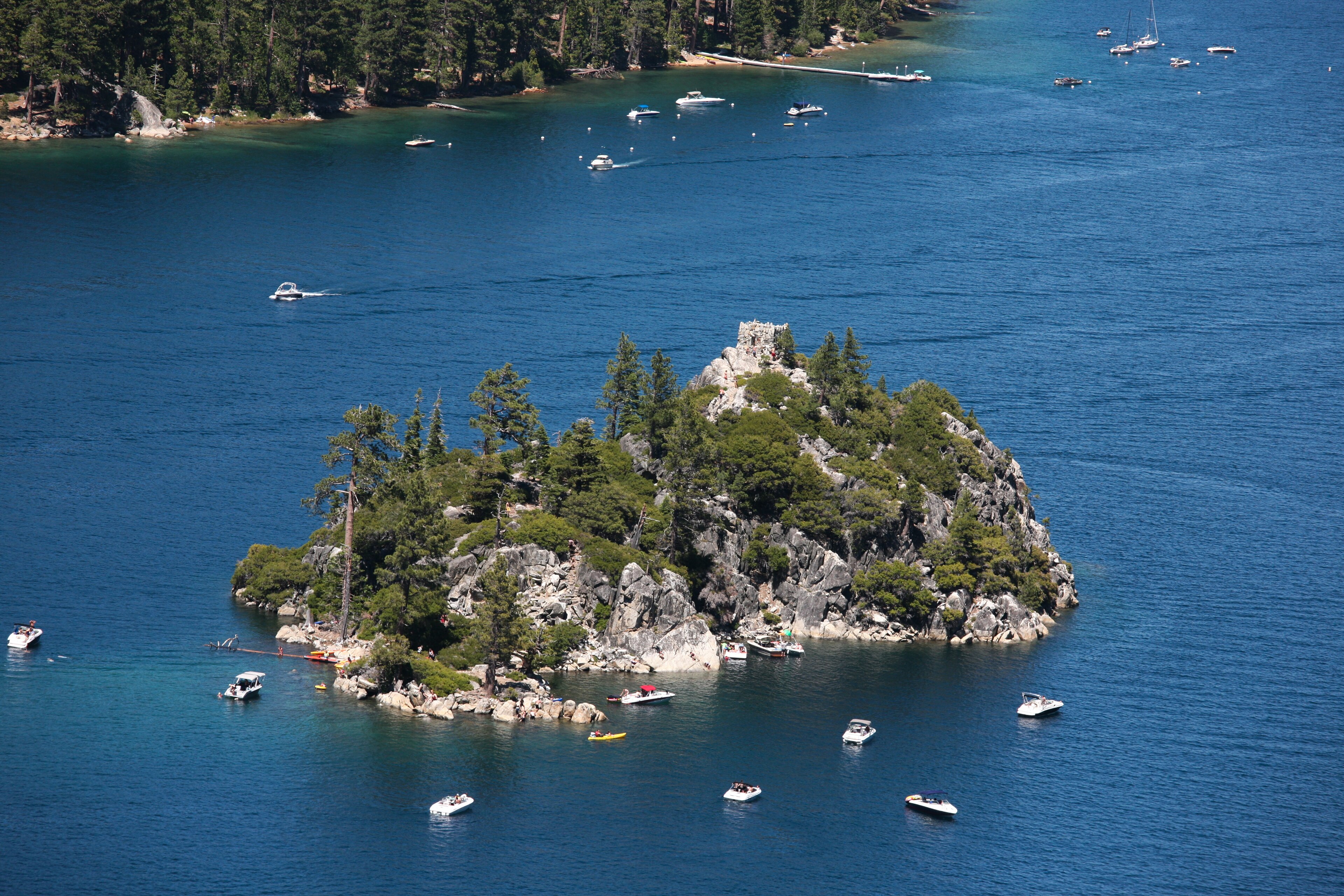

Emerald Bay is the most photographed place on Lake Tahoe and it is worth the attention, which is not always true.
It is a narrow glacial inlet, almost enclosed, with Fannette Island in the middle of it, the only island in the entire lake. At the head of the bay stands Vikingsholm, a 38-room mansion built in 1929 in the style of an eleventh-century Scandinavian castle. The bay is a National Natural Landmark and the park includes an underwater park protecting sunken barges and boats.
All of it requires walking down a steep mile, and back up.
Vikingsholm
Lora Josephine Knight bought the head of the bay in 1928. She was a wealthy widow and an investor who had helped fund Charles Lindbergh's transatlantic flight, and she wanted a summer house.
She hired her nephew, the Swedish architect Lennart Palme, and the two of them toured Scandinavia looking at churches, farms and castles. What they built is a serious piece of Nordic revival architecture, with hand-hewn timbers, intricate carving, dragon beams and a sod roof planted with wildflowers. Much of the work was done by Scandinavian craftsmen using traditional methods, no trees on the site were felled to build it, and all thirty-eight rooms were completed in a single summer season in 1929.
On Fannette Island she built a small stone teahouse and had her staff row her out for tea, and the shell of it still stands on the summit of the island. Knight summered here until her death in 1945, the state acquired the property in 1953, and tours run in season and are the only way inside.
Getting down there
This is the practical thing everyone underestimates. The Vikingsholm Trail drops about one mile with roughly 400 to 500 feet of descent from the parking lot on Highway 89 to the head of the bay.
Going down is easy. Coming back up, at 6,200 feet of elevation, in the afternoon, is not, and this is by a wide margin the most common complaint and the most common cause of trouble here. Allow an hour up, take water, and if you are not confident, the view from the top is excellent and free.
Parking is the other problem. The lots at Emerald Bay and at Eagle Falls fill extremely early in summer, and roadside parking on Highway 89 is limited, dangerous and heavily enforced.
Eagle Falls and Desolation
Directly across the highway from the Vikingsholm parking lot is one of the best trailheads in the Sierra. Upper Eagle Falls is a few minutes' walk to a waterfall and a footbridge, and Lower Eagle Falls drops toward the bay near Vikingsholm.
Eagle Lake is the one to do: roughly two miles round trip with about 400 feet of gain to a small lake in a granite bowl, and one of the highest-value short hikes at Tahoe. Beyond it the trail continues into Desolation proper toward Velma Lakes and Dicks Pass, which is serious backcountry with an overnight quota system administered by the Forest Service, and Desolation Wilderness is among the most heavily used wilderness areas per acre in the United States, which is why the permit system exists at all.
The detail worth catching is that the Eagle Lake trail crosses into the Desolation Wilderness, so a self-issue day permit is required at the trailhead. That boundary sits a short distance up a two-mile walk that most people treat as a casual stop across the road from Vikingsholm, and nothing about the parking lot suggests you are about to enter a permitted wilderness. Guidepole Hike carries the wilderness boundary and its permit requirement against the trail, which here is the difference between a signed self-issue slip and a conversation with a ranger.
The Rubicon Trail
The park's long walk, and the best lakeside trail at Tahoe. The Rubicon Trail runs roughly 4.5 miles one way from Vikingsholm north along the shoreline to D.L. Bliss State Park, contouring above the water on rocky ledges with continuous views into the lake.
The water clarity is the point, because Tahoe's famous transparency means you look down through many feet of water onto pale granite, and the color gradient from turquoise shallows to deep blue is extraordinary. Done one way with a shuttle it is a superb half day, and out and back is nine miles. D.L. Bliss at the northern end has Rubicon Point, where the lake bottom drops away steeply very close to shore, and Lester Beach.
Glaciers, and the shape of the bay
Emerald Bay is glacial and reading it that way makes the landscape legible. During the last glaciation, ice flowed east out of the Sierra crest and down this valley into the Tahoe basin, carving the classic U-shaped trough the bay now occupies.
Fannette Island is a roche moutonnée, a resistant knob of rock the ice flowed over and around, smoothed and gently sloped on the upstream side and plucked steeper on the downstream side, and the asymmetry is visible from the highway viewpoint once you know to look. The moraine at the bay's mouth is what nearly closes it off from the main lake, leaving the narrow entrance. And Eagle Lake above sits in a cirque, with Desolation Wilderness behind it a textbook glaciated granite landscape of polished slabs, erratics and lake-filled basins.
The granite itself is far older, part of the Sierra Nevada batholith, magma that cooled underground roughly a hundred million years ago and has since been uplifted and stripped bare.
The lake, and why it is that color
Tahoe's clarity is the reason Emerald Bay photographs the way it does, and it is a measurable and declining thing. Lake Tahoe holds about 39 trillion gallons, is 1,645 feet deep at its deepest point, and is the second-deepest lake in the United States after Crater Lake. Its water is about 99.994 percent pure, comparable to distilled water, which is why light penetrates so far and why the shallow granite shelves read turquoise while the drop-offs go deep blue.
Clarity is measured by lowering a white Secchi disk until it disappears. In 1968 the figure was about 102 feet, it declined through the following decades to around 64 feet at its worst, and it has partially recovered with substantial management effort. The causes of the decline were fine sediment from development and road runoff plus nutrients feeding algae, rather than sewage, which was diverted out of the basin decades ago.
That is why the basin is so heavily regulated, with erosion control on every construction project, stormwater treatment and restrictions on shoreline development. Invasive species are now the other front, since Asian clams, Eurasian watermilfoil and quagga mussel threats have produced mandatory boat inspections at every launch in the basin. So the color you are photographing is a managed outcome rather than a natural constant, and it took decades of expensive work to stop it degrading.
The Emerald Bay Rubicon TrailThe underwater park
An unusual designation worth knowing about. Emerald Bay State Underwater Park protects a set of sunken vessels: barges used to carry materials for the estates, and recreational boats from the early twentieth century, deliberately scuttled or lost.
A maritime heritage underwater trail with markers runs at depths reachable by divers, and it was the first of its kind in California. The cold, clear, fresh water preserves wood far better than salt water does, which is why the wrecks are in the condition they are, and some are visible from the surface because the water is so clear.
The gear
Emerald Bay is a state park at sixty-two hundred feet on a lake shore with a highway problem, and the gear list reflects all three.
Water for the climb out, which is the item people underestimate. The walk down to Vikingsholm is a mile and it drops five hundred feet, which means the walk back is a five-hundred-foot climb at six thousand feet of elevation at the end of a warm afternoon. It catches a great many visitors.
An early alarm, which is the real answer to this park. The pullouts on Highway 89 above the bay are small, they fill by mid-morning every summer day, and people park illegally on a blind mountain highway because of it.
Sun protection, for altitude plus reflected light off the lake.
A Desolation Wilderness day permit, if you continue up to Eagle Lake or beyond, which is free, self-issued at the trailhead and required.
Layers, since a Tahoe morning and a Tahoe afternoon are different seasons.
Bear-aware food handling, because the bears around the south shore are among the most habituated in California and a car with food in it is a target.
And a shuttle plan for the Rubicon Trail, since the good version is one-way from Emerald Bay to D.L. Bliss and that leaves you four miles from your car.
Season, and winter in particular
Summer is the season and it is crowded, with parking filling by eight or nine. Autumn is the best, bringing warm days, cold nights, thin crowds and the aspens turning in the surrounding canyons. Spring brings high water in Eagle Falls and lingering snow on the higher trails into June.
Winter changes the park completely and it is worth knowing what remains. Vikingsholm closes and the trail down is snow-covered and often icy, with genuine avalanche risk on the slope above in heavy years, and Highway 89 around the bay closes periodically for avalanche control and snow removal, sometimes for days. The highway viewpoint stays open when the road does, and Emerald Bay under snow with the island dark in white water is one of the great sights in California. Eagle Falls partially freezes and is spectacular. Snowshoeing and backcountry skiing in the Desolation Wilderness above is serious avalanche terrain requiring training and equipment.
Most visitors should treat winter here as a driving and viewpoint destination rather than a hiking one, which is not a disappointment given what there is to look at.
The Rubicon Hiking Trail and Emerald BayGetting here without the parking problem
The single biggest constraint at Emerald Bay is the car, and there are ways around it. The south shore transit system runs along Highway 89 seasonally, and using it removes the parking question entirely, though services are limited. Cycling the highway is popular and spectacular, though the road around the bay is narrow, winding and shared with traffic that is looking at the view rather than the road, so it is not a relaxed ride.
By water is the best answer. Kayaking into Emerald Bay from a launch further along the shore lets you land near Vikingsholm at the boat-in campground, circle Fannette Island, and see the bay from the only angle that shows its shape properly. Boat inspections are mandatory in the Tahoe basin for anything trailered, to prevent quagga mussel introduction, while hand-carried kayaks and paddleboards have their own simpler process. Tour boats from South Lake Tahoe also run into the bay and give the view without the walk.
The rest of the practical picture: day-use parking fees apply and the lots fill early. Camping at Emerald Bay and D.L. Bliss books six months ahead and is among the most contested in California, and there is a boat-in campground at Emerald Bay as well. Dogs are restricted to paved areas and campgrounds rather than trails, as across California. Elevation is 6,200 feet at the lake and higher on the trails, which matters for anyone arriving from sea level. Fannette Island can be reached by kayak or paddleboard and closes from February to mid-June for nesting Canada geese. And bears are active, so food storage rules apply.
What to do with a day
Arrive before eight in summer, or do not drive at all. Walk down to Vikingsholm, tour the house, and look at the island and the teahouse. Climb back up early, before the heat. Then cross the highway and walk to Eagle Lake, two miles for a granite bowl and a lake, or take the Rubicon Trail north to D.L. Bliss with a shuttle, which is the best walking in the park.
And on the way back up that hill, consider that a widow in her sixties had a Scandinavian castle built here in one summer, then had herself rowed to an island to drink tea in a stone hut she also built.
More Sierra country in Eastern Sierra day hikes and Mount Whitney. California's parks are covered in Big Basin and Point Lobos, and the fee rules in six states, six ways to charge you for a trailhead.
The Sierra parks over the crest are in one day in Yosemite and three days in Yosemite, and the east side day hiking is in Eastern Sierra day hikes. The other California state parks in this library are in Mount Diablo and Calaveras Big Trees. The permit and pass questions are in state park passes by state.
A last note on the water itself, since it is what people come for. Lake Tahoe's famous clarity has been measured continuously since 1968, when a white disk was visible to just over a hundred feet down. It fell to around sixty-four feet by the late 1990s, largely from fine sediment washing off development and roads, and it has partially recovered since as stormwater controls went in. The blue is real and it is also a maintained condition rather than a permanent one.