Fish
Fish Fire
Fire Hike
Hike Bird
Bird

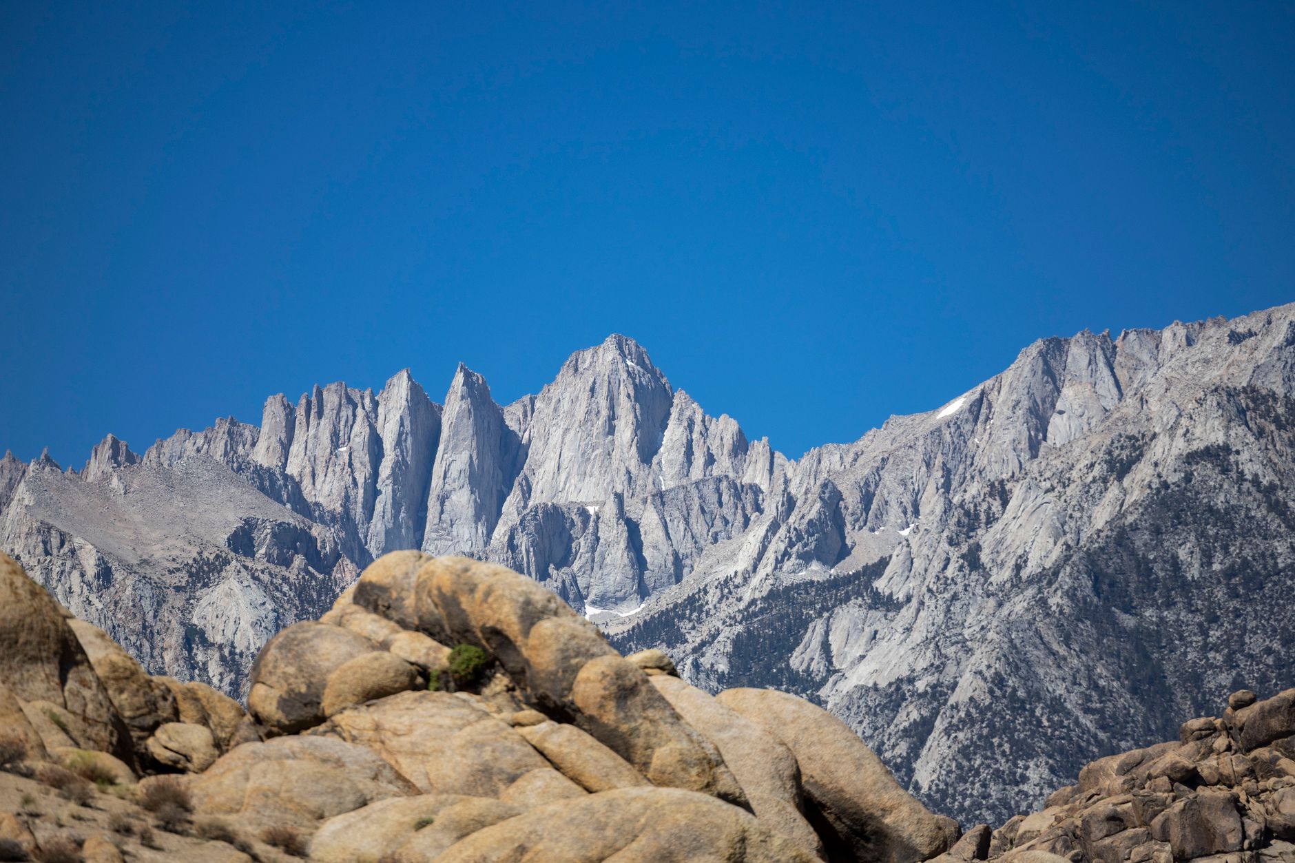

Mount Whitney is the highest point in the contiguous United States at 14,505 feet, and there is a trail all the way to the top.
No rope, no glacier, no technical climbing, just a maintained path from Whitney Portal to the summit, walkable by anyone fit enough to cover the distance. That accessibility is the whole appeal and it is also the trap, because the numbers involved are considerably larger than the word "trail" suggests.
Twenty-two miles round trip. 6,656 feet of gain. A finish above 14,000 feet. People attempt it as a day hike routinely, and a substantial share turn around, almost always for the same reason.
How to Hike Mount WhitneyThe permit, and the February window
Whitney runs one of the most competitive lotteries in American hiking, and you cannot walk up. Applications run February 1 to March 1 through Recreation.gov covering the quota season, results are posted March 15, and successful applicants have until April 21 to claim and pay for their awarded dates.
The quota allows roughly 100 day-use and 60 overnight spaces per day, around 160 people daily on the mountain, split between day hikers and those camping at Outpost Camp or Trail Camp partway up. Quota season runs May 1 to November 1 and that window is the competitive one, because outside it permits are easier but the mountain is a winter mountaineering objective rather than a hike, requiring axe, crampons and the skills to use them.
Unclaimed permits and cancellations recirculate after the acceptance deadline, which is the second chance most applicants never check. Confirm the current year's dates with the Inyo National Forest before planning around any of this.
The route
From Whitney Portal at about 8,360 feet, the Mount Whitney Trail climbs steadily through several distinct zones. The lower trail switchbacks through pine forest, crossing streams and gaining altitude steadily, and this is the pleasant part, usually walked in the dark. Outpost Camp and Mirror Lake come at around 10,000 to 10,600 feet, the first of the established camps and a natural water stop, and Trail Camp at about 12,000 feet is the last water on the route and where overnight parties sleep. Day hikers typically reach it around dawn or shortly after, and it is where a lot of people first notice the altitude properly.
Above Trail Camp the 99 Switchbacks climb roughly 1,600 feet to Trail Crest. There are famously ninety-nine of them, though the actual count is closer to ninety-seven, and they are the psychological crux of the route: relentless, exposed, and at an altitude where everything is slow. There is a cable-protected section near the top that holds snow and ice well into summer.
Trail Crest at 13,600 feet is where you join the John Muir Trail and cross onto the west side of the crest with the Sierra opening out below. From there the final two miles traverse the back side of the ridge to the summit, undulating, rocky, exposed and slow, and this stretch is far longer in practice than it looks on a map because you are above 13,600 feet the entire way. The summit itself is a broad plateau with a stone hut, built in 1909, that is emphatically not a lightning shelter.
Trail Crest is also a jurisdictional line, which surprises people. You start on Inyo National Forest ground and cross into Sequoia National Park at 13,600 feet, where park rules apply for the rest of the route, and dogs are not permitted above a certain point well below that. Guidepole Hike carries the managing agency and where it changes along a route, which on a trail that swaps agencies at its highest point is not something any sign at the Portal will tell you.
Eight Tips for Hiking Mount Whitney: Permits, Water, Training and Wag BagsAltitude is what ends most attempts
This is the honest core of the article. Whitney is not technically difficult and it is not, by ultra standards, extraordinarily long. What it is, is high, and almost everyone who ascends rapidly to 11,000 feet develops some degree of acute mountain sickness, while Whitney takes you 3,500 feet beyond that in a single day. Most people arrive from sea level or close to it, drive up to Lone Pine, sleep one night and start at 3am, which is close to a worst-case acclimatization profile.
Sleeping high before you hike is the single highest-return preparation available. Whitney Portal at 8,360 feet, the campgrounds up the Portal road, or anywhere in the Eastern Sierra above 8,000 feet will do, and two or three nights above 8,000 feet before summit day transforms the odds. Adding an acclimatization hike in the days before helps further, and Little Lakes Valley from Mosquito Flat at 10,244 feet is the classic, being a good day in its own right.
On the mountain itself, go slower than feels necessary from the start, especially in the first hours when you are fresh and it is dark and cool. Drink and eat continuously, because appetite disappears at altitude while your energy expenditure rises. Know the symptoms, meaning headache, nausea, unusual fatigue and dizziness, and understand that the correct response is to stop climbing and to descend if they do not resolve. Acetazolamide is worth discussing with a doctor if you are ascending on a compressed schedule, though it is not a substitute for acclimatizing.
The pattern on Whitney is consistent: strong, fit people turning back at Trail Camp or on the switchbacks with a headache they cannot shift.
The 3 a.m. start
Alpine starts on Whitney are not machismo, and they exist for concrete reasons. Afternoon thunderstorms build over the Sierra crest with real speed in summer, and the last two miles plus the summit plateau are the most exposed ground on the route, above 13,600 feet with no shelter. The stone hut is a hut rather than protection from lightning, and people have been killed on that plateau.
Beyond the weather, twenty-two miles takes 12 to 16 hours for most successful parties, so starting at 3am puts you on the summit around midday and back down in daylight. Descending 6,656 feet in the dark on tired legs at the end of a sixteen-hour day is how ankles get broken. And the cable section on the switchbacks is safer in the cool morning before it thaws and refreezes.
The practical shape of the day is to leave the Portal between 2am and 4am, reach Trail Camp around sunrise, top out late morning, and be off the switchbacks by early afternoon.
The gear
Twenty-two miles and sixty-two hundred feet of gain finishing at fourteen thousand five hundred feet, done in a day, is a serious undertaking and the gear list reflects it.
A headlamp with spare batteries, because the standard start is between two and four in the morning and a slow party finishes in the dark as well.
Three liters of water capacity plus a filter, since there is water on the lower trail and none above Trail Camp, and the last six miles are the driest and highest.
WAG bags, which are required rather than encouraged. Human waste does not decompose at that altitude, the Forest Service issues the bags with the permit, and packing it out is a condition of being there.
An insulated jacket and a windshell, because the summit plateau is exposed and cold in every month, and a July summit at dawn can be in the twenties with wind.
Kahtoola MICROspikes, and in early season an ice axe as well. The ninety-nine switchbacks hold snow into July in a big year, and the chute above them is where the accidents happen.
Trekking poles, for a twenty-two-mile day that is almost entirely up and then almost entirely down.
And high-SPF sunscreen and lip balm, because the ultraviolet at fourteen thousand feet is roughly double what it is at sea level and the reflected light off granite and snow adds to it.
Conditions and season
July to September is the reliable window, with the trail generally clear of snow. Early season, meaning May and June, frequently means snow on the switchbacks and at the cable section, and in a heavy year an ice axe and crampons are required, which is the most common way people get into trouble on a permit they won for June.
Late season, in October, is cold and can bring the first storms, with shorter days compressing an already long schedule. Winter is a mountaineering route rather than a hike. Check current conditions with the Inyo National Forest and recent trip reports rather than assuming a summer permit means a summer trail.
Overnight instead of a day hike
This is worth considering seriously, because it solves the problem the day hike creates. The 60 overnight permits per day allow camping at Outpost Camp at around 10,300 feet or Trail Camp at about 12,000, both partway up the route, and splitting the climb across two days does three useful things.
It acclimatizes you en route, because a night at 12,000 feet is a genuine physiological benefit for the summit push in a way that driving up and starting at 3am is not. It shortens summit day dramatically, since from Trail Camp the summit and return is a fraction of the 22-mile day, which means less exposure to afternoon weather and a far more relaxed schedule. And it makes the trip about the mountain rather than an endurance exercise, because the Sierra above Trail Camp at dawn is worth being present for.
The costs are carrying overnight weight up 4,000 feet, a bear canister requirement, sleeping badly at 12,000 feet, and a separate and also competitive permit allocation. For anyone who has not spent time above 12,000 feet before, the overnight is the more sensible objective and the more likely successful one.
The mountain's other routes
It is worth knowing that the Whitney Trail is one of several ways up, because the others explain some of what you will see. The Mountaineer's Route is a steep couloir on the north side, a Class 3 scramble in summer and a mountaineering route under snow, considerably shorter and considerably more serious, with its own permit allocation. The East Face and East Buttress are classic technical rock climbs, and the climbers you may see with ropes at the Portal are usually headed there.
From the west, the summit is reachable from the John Muir Trail and Sequoia's backcountry, which is how thru-hikers arrive, and the JMT officially terminates on the summit, so northbound hikers finishing months on the trail are a common sight up there.
That mix is part of what makes the summit plateau odd. On a summer morning it holds day hikers who started at 3am, backpackers up from Trail Camp, JMT finishers in tears, and occasionally climbers topping out from the east face.
If you do not get a permit
The Eastern Sierra is full of alternatives that need no lottery. Little Lakes Valley from Mosquito Flat gives you 10,000-foot alpine scenery for a fraction of the effort. Mount Langley nearby is another fourteener with an easier permit situation. And Kearsarge Pass, Bishop Pass and the Big Pine Lakes are all superb and considerably less contested.
And honestly: Whitney is the highest, not the most beautiful. Plenty of people who have done both prefer the country around it.
Practical notes
Bear canisters are required for overnight trips, and food storage lockers are provided at the Portal. Human waste must be packed out using the WAG bags issued with your permit, which is a hard requirement on Whitney and it is enforced, because the alpine environment above treeline does not process waste.
Trail Camp is the last water, so filter there and carry enough for the summit and back, which is a long stretch with nothing on it. Whitney Portal has a store, a campground and famously large pancakes, seasonally. And Lone Pine at 3,700 feet is where most people stay, which is too low to acclimatize you, so sleeping higher is worth the discomfort.
The trail goes all the way to the top
Apply in February, expect competition, and check for released permits after the April deadline. Sleep two or three nights above 8,000 feet before summit day, because that matters more than your fitness. Start between 2 and 4am. Carry water from Trail Camp for the whole upper mountain, and pack out your waste.
Then go slowly, eat and drink continuously, and treat a headache above 12,000 feet as a reason to stop rather than something to push through.
The trail goes all the way to the top. The air does not.
The physiology behind most Whitney failures is covered properly in hiking at altitude, and the lottery system in permit lotteries explained. For acclimatization days at 10,000 feet nearby, see Eastern Sierra day hikes.
The rest of this side of the range, at gentler elevations, is in Eastern Sierra day hikes. The other great permitted Sierra day is in the Half Dome cables, and the permitless big view is in Clouds Rest. The park on the far side of the crest is covered in three days in Yosemite, and the big-tree park to the north is in one day in Sequoia National Park.