Fish
Fish Fire
Fire Hike
Hike Bird
Bird

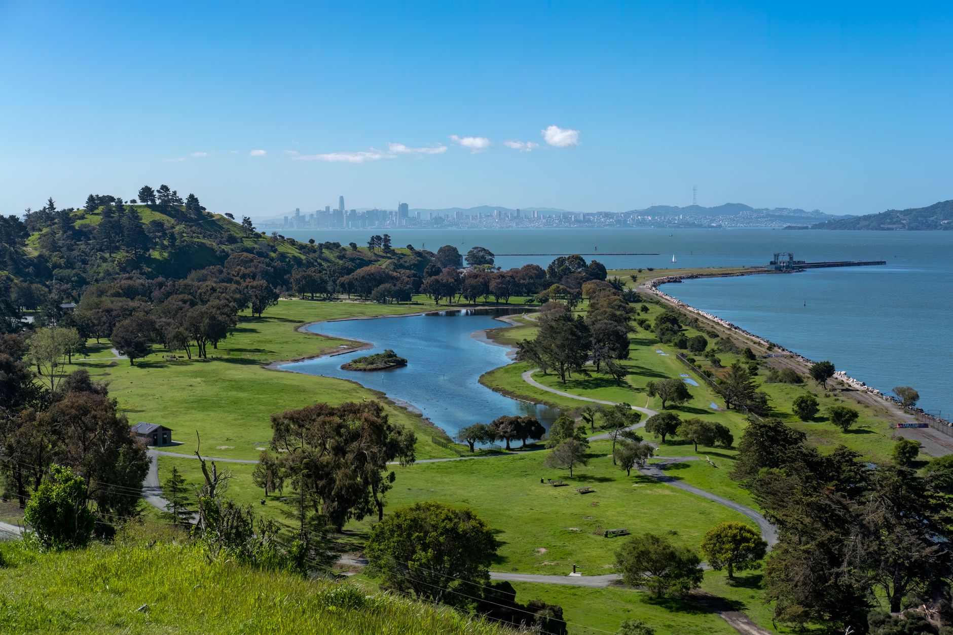

There is a particular kind of San Francisco Bay birding experience where you are standing on a levee between a salt pond and a tidal slough, with a freeway behind you and a tech campus across the water, watching twenty thousand shorebirds wheel in unison over ground that was industrial salt production a decade ago.
It is not wilderness and it does not pretend to be. It is one of the most important shorebird sites on the Pacific coast.
What happened to the bay, and the refuge that followed
Roughly ninety percent of San Francisco Bay's historic tidal marsh has been lost, diked and filled for salt production, agriculture and development from the Gold Rush onward. The bay is nonetheless a critical link in the Pacific Flyway, holding very large numbers of wintering and migrating shorebirds and waterfowl, because there is very little else left on this stretch of coast. What survives is a patchwork of remnant marsh, diked former salt pond and restored tidal wetland, and the last of those is growing fast.
Don Edwards San Francisco Bay National Wildlife Refuge was established in 1972 as one of the first urban national wildlife refuges in the United States, after a long campaign by local residents against filling the south bay. That matters as precedent. Before it, the working assumption was that national wildlife refuges belonged in remote places, and Don Edwards established that a refuge could sit in the middle of seven million people and be worth having.
The refuge now covers roughly thirty thousand acres around the south bay in units scattered from Fremont round to Alviso and up the peninsula, and entry is free. The Environmental Education Center at Alviso and the visitor center at Fremont are the two staffed points, both with trails from the door. The units worth knowing are Alviso for salt ponds and sloughs, Fremont near the Dumbarton Bridge for marsh and pond edge, Ravenswood on the peninsula side, and Warm Springs for seasonal wetland.
The Don Edwards San Francisco Bay National Wildlife RefugeThe salt ponds, and the restoration
The South Bay Salt Pond Restoration Project is converting roughly fifteen thousand acres of former commercial salt ponds back to tidal marsh and managed pond, and it is the largest tidal wetland restoration on the west coast.
For a birder this creates an unusual situation, because the habitat is deliberately mixed rather than uniformly restored. Some ponds are being returned to tidal marsh for Ridgway's Rail and the marsh community. Others are being held as managed ponds at specific salinities and depths, because the ponds themselves became critical habitat over the decades they existed, supporting Western Snowy Plover, American Avocet, Black-necked Stilt, Eared Grebe and enormous numbers of Northern Shoveler and Ruddy Duck.
The practical consequence is that what a given pond holds changes as the project proceeds, and a site that was excellent five years ago may now be marsh with a completely different bird list. Check recent reports rather than an old guide, because here the guide goes out of date faster than the birds do.
The tidal marsh endemics
The bay's marsh holds a set of species and subspecies found nowhere else, and they are the conservation reason the restoration exists at all.
-
Ridgway's Rail, formerly lumped as Clapper Rail, has a California subspecies confined to San Francisco Bay marshes and listed as endangered. It is secretive and lives in cordgrass, and the reliable way to see one is on a very high tide when rising water forces it out of cover onto the marsh edge.
-
California Black Rail is smaller, even more secretive, and a genuinely difficult bird. It is heard far more than seen, and disturbing it to try to see it is not acceptable.
-
Salt Marsh Common Yellowthroat and San Pablo Song Sparrow, along with the Alameda and Samuel's Song Sparrow subspecies, are locally distinct forms shaped by the marsh, noticeably darker and heavier-billed than inland birds.
-
Salt Marsh Harvest Mouse, not a bird but part of the same story, is endemic to these marshes and endangered, and is one of the species the restoration is designed around.
The common thread is that all of them need mature tidal marsh with high-tide refuge, which is precisely what a diked salt pond does not provide and what the restoration is rebuilding. It also explains why so much of the marsh is closed to foot traffic. A person walking a marsh at high tide is walking through the only refuge these animals have.
Cali's Crib: Don Edwards San Francisco Bay National Wildlife RefugeThe shorebird numbers, and why they matter
A little scale helps, because the flock in front of you is more significant than it looks. San Francisco Bay is recognized as a site of hemispheric importance in the Western Hemisphere Shorebird Reserve Network and supports a very large share of the shorebirds using the Pacific Flyway, with estimates of peak counts running into the hundreds of thousands of birds. Western Sandpiper and Dunlin do most of the work by volume, alongside Least Sandpiper, Marbled Godwit, Willet, American Avocet, Black-necked Stilt, Long-billed Curlew, Black-bellied Plover, Semipalmated Plover and both dowitchers.
The point of the number is the bottleneck. Because so much coastal wetland between Alaska and Mexico has been lost, the birds now depend on a small number of remaining sites, and the bay is one of the largest of them, which means a bad year here has consequences along the entire flyway.
That is the argument for the restoration, for the closures, and for staying on the levee rather than walking out onto the pan for a better photograph. A flushed roost costs the birds energy at exactly the point in the journey when they have none spare.
The gear
Bay birding is levee walking in wind, on flats that run on the tide, and the gear list is short and specific.
A spotting scope, because the shorebird flocks here are enormous and distant. The interesting work is picking a Red Knot or a Ruff out of ten thousand Western Sandpipers on a far pond, and that is not binocular work.
A tide table, which governs the entire day. A high tide pushes birds off the flats and onto the levees and pond edges where you can actually see them; a low tide scatters them across a mile of mud. For shorebirds you want the couple of hours either side of high water.
Wind-proof layers, since the levees are completely exposed and the afternoon wind through the Golden Gate is a reliable feature rather than a possibility.
Sun protection, for the same reason: there is no shade anywhere on a salt pond levee.
Comfortable walking shoes, because the productive routes are flat and long rather than short and steep, and four miles of levee is a normal morning.
Recent trip reports, since the ponds are actively being reconfigured by the restoration project and which pond holds what changes from year to year.
And a land ownership map, because the refuge, the state lands, the flood control districts and a good deal of private salt-making infrastructure interleave around the south bay without much signage.
The east bay and the peninsula
Hayward Regional Shoreline on the east bay gives levee walking, restored marsh and reliable shorebird roosts at high tide, and Coyote Hills Regional Park just inland from the Fremont units adds freshwater marsh, grassland and a hill to look down from, which is a useful thing to have on a shoreline this flat. Palo Alto Baylands is the peninsula equivalent, with an excellent boardwalk into the marsh and Ridgway's Rail regularly visible on a high tide.
Shoreline Park at Mountain View and Cesar Chavez Park in Berkeley both hold Burrowing Owls, a species that has declined severely in the region and is now largely dependent on a handful of managed sites, which makes those two parks more important than their suburban settings suggest. Point Isabel and the Berkeley shoreline give bay views, gulls and wintering waterbirds at close range.
Lake Merritt in Oakland deserves its own mention. It was designated a wildlife refuge in 1870 and is generally regarded as the first official wildlife refuge in North America, an urban tidal lagoon in the middle of a city that still holds wintering ducks and gulls close enough to study without optics. Alcatraz, out in the bay, holds substantial seabird colonies including Brandt's Cormorant, Western Gull, Pigeon Guillemot and Black-crowned Night-Heron, with parts of the island closed during the breeding season.
The San Francisco side
The south bay has the numbers and the city itself is worth a day. Golden Gate Park functions as a migrant trap on a largely treeless peninsula, and its isolated groves have produced a long list of eastern vagrants over the decades, with Chain of Lakes and Middle Lake holding waterfowl. Lands End and Sutro Baths give rocky shoreline with Black Oystercatcher, Surfbird, Black Turnstone and Wandering Tattler on the rocks, plus seawatching potential in the right conditions.
Fort Funston is a coastal bluff with a Bank Swallow colony, one of very few remaining on the California coast, plus raptor movement along the bluff edge. Crissy Field and the Presidio combine restored tidal marsh, beach and woodland that acts as another migrant trap, and Heron's Head Park on the southeast waterfront is restored wetland in a former industrial area and the best shorebird site inside the city limits.
Hawk Hill, just across the Golden Gate in the Marin Headlands, hosts the Golden Gate Raptor Observatory count each autumn and is one of the premier hawk watches on the west coast. It is fifteen minutes from the city and a completely different day's birding.
Timing
-
Autumn, roughly August through October, is the southbound shorebird peak and the best of the year.
-
Winter holds enormous waterfowl numbers on the ponds and open bay, plus the best raptor showing.
-
Spring, April into May, gives northbound shorebirds in breeding plumage, which is the more attractive if less numerous version.
-
Summer is breeding season for the marsh and pond nesters, and the quietest for variety.
Tides govern everything else. As with any estuary, low water spreads birds across the flats to feed and high water pushes them into countable roosts. The managed ponds are the exception and are worth working at any tide, which is precisely why they matter to a visitor with one day and no control over the tide table.
Getting around, and a first day
The bay is spread out and the logistics can eat a day if you let them. The sites sit on both sides of the water and the bridges are the constraint, since crossing between the peninsula and the east bay at the wrong hour can cost an hour, with the Dumbarton and San Mateo bridges the useful south bay crossings. Plan a day on one side accordingly: Alviso, Palo Alto Baylands and Shoreline make a peninsula day, while Coyote Hills, Hayward and Point Isabel make an east bay one.
Most refuge and regional park lots are free, which is a pleasant surprise in this region, though some regional parks charge in peak season. City parking is a different matter, and Golden Gate Park, Lands End and the Presidio all have their own constraints with diligent enforcement. Public transit reaches some of it, particularly the city sites and parts of the east bay shoreline, but the south bay salt ponds effectively need a car. Start early regardless, because traffic here is bad by mid-morning and the birding is better before it anyway.
For a first day, begin at the Environmental Education Center at Alviso on a rising tide, walk the levees, and give the ponds proper scope time. Cross to Palo Alto Baylands at midday for the high-tide rail chance and the boardwalk. Take Coyote Hills or Hayward Regional Shoreline in the afternoon, and end at Shoreline Park or Cesar Chavez Park for Burrowing Owls in the last light. All of it is free, all of it is within an hour of the rest, and collectively it is as good a day's shorebirding as anywhere in the country.
One thing to carry with you. This shoreline is among the most fragmented ownership maps in the country, with federal refuge units, regional park districts, city parks, county land, flood control districts, water districts, private tech campuses holding public trail easements and active industrial ground all interleaved along the same levee system. A levee that is open public trail can become a closed maintenance road at an unmarked point, which is the normal condition here rather than a hypothetical. Guidepole Bird carries the ownership and access layer under the birds, which on this shoreline means knowing whose levee you are on before you are two miles along it.
For the wider region, Central Valley waterfowl is two hours inland, and Point Reyes is an hour north for the autumn vagrant season.
The tide logic that governs everything here is in shorebirds and tides, and the refuge mandate that shapes the management is in a wildlife refuge is not a park. The vagrant hunting an hour north is in Point Reyes and its vagrants, and the enormous waterfowl concentrations upstate are in Central Valley waterfowl. The nesting closures that fence off parts of the levee system in spring are in nesting and seasonal closures explained.