Fish
Fish Fire
Fire Hike
Hike Bird
Bird

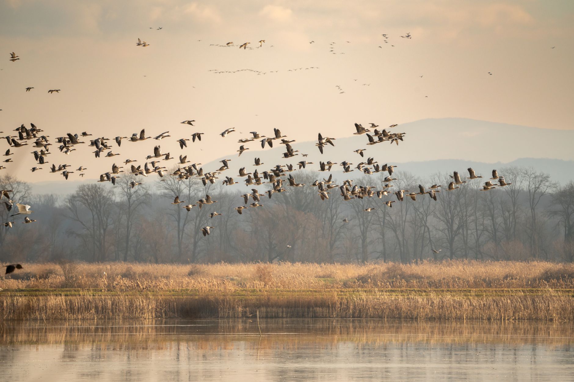

Drive Interstate 5 north of Sacramento in December and the fields on either side are full of water and white birds. Pull off at a refuge, pay six dollars, and drive slowly for six miles with the window down while several hundred thousand waterfowl get on with their winter about forty feet away.
The Central Valley in winter is one of the great wildlife spectacles in North America, and it is startlingly easy to access.
What happened to the valley
The context matters, because the numbers only make sense against it. The Central Valley was historically a vast seasonal wetland, flooded each winter by rivers running off the Sierra, and it supported waterfowl concentrations that early accounts struggled to describe. Roughly 95 percent of those wetlands have been lost, drained and converted to agriculture and development over the last century and a half.
The birds did not leave. They compressed. What holds them now is a patchwork of national wildlife refuges, state wildlife areas, private duck clubs and, critically, flooded rice fields, because rice growers in the Sacramento Valley flood harvested fields in winter to break down straw, producing hundreds of thousands of acres of shallow water with waste grain in it at exactly the right time of year.
That accidental partnership between a crop and a flyway is doing an enormous amount of the work, and it is one of the more interesting conservation stories in the country precisely because nobody designed it.
The Sacramento complex
The Sacramento National Wildlife Refuge Complex is the anchor and the easiest place to start, comprising five national wildlife refuges, Sacramento, Delevan, Colusa, Sutter and Sacramento River, plus three wildlife management areas.
-
Sacramento NWR has a 6-mile auto tour and Colusa NWR has a 3-mile auto tour. Both are the main way to see the refuges and both are excellent.
-
Fees are modest: a one-day pass is $6, an annual pass is $12, and a commercial vehicle is $20. A Federal Duck Stamp or America the Beautiful pass is also accepted, and at these prices the annual pass pays for itself on the second visit.
-
Hours run from one hour before sunrise to one hour after sunset, year-round, which is unusually generous and gives you the light at both ends of the day.
-
Seasonal trails at Sacramento and Sutter open February 15 and close after June 30, which is the reverse of what most visitors assume: the walking access is in the quiet season, and the winter concentration is viewed from the vehicle.
-
Bicycling is limited to May 15 through August 15 on designated routes.
Timing, and the peak
Waterfowl numbers peak in late November and early December, which is the answer if you want one date. October brings the first big arrivals and the start of the rice flooding. November and December are the peak, with Snow Goose, Ross's Goose, Greater White-fronted Goose, Northern Pintail and a long list of ducks in numbers difficult to estimate by eye. January and February hold high numbers with better weather and fewer people, plus the best raptor showing of the year. Late February and March see the northbound departure, often abrupt. And spring and summer are a different refuge entirely, with breeding waterbirds, the seasonal trails open, and almost nobody there.
The fog is the variable. Tule fog can sit in the valley for days, reducing visibility to a few hundred feet, and it is the main reason a well-planned December trip fails.
Sorting the white geese
On a valley refuge in December you are looking at tens of thousands of white birds, and pulling them apart is the actual skill.
Snow Goose is the default, with a heavy pink bill carrying a black grinning patch along the cutting edge, a longer neck and a larger body. Ross's Goose is common here, unlike in most of the country, and worth learning properly: smaller and rounder, with a short stubby bill lacking the grinning patch, often showing a bluish warty base on adults, and a steeper forehead that gives a distinctly different head shape. Intermediates exist, because the two species hybridize and a proportion of birds are not safely assignable, which is normal rather than a personal failing. Blue morphs occur in both and are much scarcer in the Pacific Flyway than in the mid-continent, which makes finding one here a real piece of work. And Greater White-fronted Goose is the third abundant species, gray-brown with orange legs, a pink bill, black belly barring on adults and a distinctive high laughing call that is usually how you find them in a mixed flock.
The habit that pays is scanning the flock edges where individual birds are separable, rather than the dense middle where everything is a white blur.
The rice, in more detail
Since flooded rice is doing so much of the work, it is worth understanding how it functions. Harvest happens in autumn, leaving stubble and a significant amount of waste grain in the field, and growers then flood the fields over winter, historically to decompose the straw after burning was restricted, which turned a disposal problem into shallow-water habitat across a very large acreage.
Water depth matters enormously. A few inches suits dabbling ducks and geese, a very shallow drawdown produces shorebird habitat, and deeper water suits divers, so which birds are in which field on a given week is a function of exactly how it has been managed. Timing matters just as much, since fields flooded early in autumn catch the arriving waterfowl while fields drawn down in late winter and spring produce mudflat for northbound shorebirds.
There are now coordinated programs that pay growers to flood or hold water at specific depths at specific times to fill gaps in habitat availability, which is one of the more elegant conservation mechanisms in the country: it rents habitat rather than buying land, and it works with the existing agricultural calendar rather than against it. For a birder driving the county roads, the practical upshot is that the best field changes weekly, so scan every flooded field rather than heading for a remembered spot.
Sandhill Cranes Flock to the Sacramento ValleyThe cranes, which are a separate trip
Sandhill Cranes winter in the valley in large numbers and are best worked as their own outing, because the good sites are further south and the timing is different.
Woodbridge Ecological Reserve near Lodi is the classic managed crane viewing site, with docent-led tours in season. Cosumnes River Preserve, south of Sacramento, gives cranes plus a lovely valley oak riparian forest holding a completely different bird community. Merced National Wildlife Refuge, further south, holds both Lesser and Greater Sandhill Cranes along with enormous numbers of Ross's Geese and has its own auto tour. And San Luis National Wildlife Refuge Complex, in the San Joaquin, adds tule elk and a different set of units.
The crane event is the evening fly-in to roost, and that is the thing to plan around, because cranes feed in fields through the day and return to shallow water at dusk, so being in position for the last hour of light is the entire trip.
The gear
Valley waterfowl is car birding, and the equipment list follows from the fact that the car is the hide.
A window mount or a beanbag rest is the first item and the one that changes the day most. Birds on a refuge auto tour tolerate a vehicle and do not tolerate a person, so everything you do you will do through a window, and handheld optics at a window in cold air produce shaky views. A beanbag over a lowered glass costs almost nothing and steadies a scope completely.
The annual refuge pass, currently twelve dollars, which covers the Sacramento complex and is cheaper than paying at two units.
A spotting scope, because valley flocks are enormous and distant, and the interesting work is picking a Ross's Goose out of thirty thousand Snows or finding the one Emperor Goose that turns up every few winters.
Warm layers for a stationary morning, since sitting in a car with the window down at first light in a Central Valley January is colder than the forecast number suggests.
A fog forecast checked the night before. Tule fog is the thing that ruins a valley trip, it forms overnight in exactly the conditions that make a still winter morning, and it can hold visibility under fifty yards until midday.
A land ownership map, because the state wildlife areas around the federal refuges have their own permits, their own hunt days and their own boundaries.
And patience for the last hour of light, which is when the flyoff happens and the reason to be there at all.
The raptor side of the valley
The waterfowl are the reason to come and the raptors are what many people remember. Ferruginous Hawk winters in the valley and on the surrounding grassland and is the largest and palest of the buteos here. Rough-legged Hawk arrives from the Arctic, hovering over field edges with the black belly patch and dark carpal marks. Northern Harrier quarters low over every marsh and stubble field, and White-tailed Kite hovers over the grassland margins, with the valley one of the strongholds for the species.
Peregrine and Prairie Falcon both hunt the waterfowl concentrations, and a peregrine stoop into a flock of pintail is worth the entire trip. Merlin and American Kestrel work smaller prey on the fence lines. Burrowing Owl persists in ditch banks and levees in places and is worth scanning for on the county roads. And Short-eared Owl hunts at dusk over grassland and fallow ground, which makes the last half hour of light the time to look.
The pattern to internalize is that the raptors are on the edges and the roads rather than on the auto tour. Driving the county roads between refuges in the middle of the day, when the waterfowl viewing is slow, is exactly when the raptor list gets built.
The hunting overlap, stated plainly
This is a working landscape and the seasons overlap the peak. Much of the refuge acreage is open to waterfowl hunting on specified days, and many of the surrounding wetlands are private duck clubs. The refuges manage this by zoning, so auto tour routes and viewing areas sit in closed zones and the birds you are watching are on ground where nobody is shooting.
That is not a compromise, it is the design. Closed zones are why the birds sit still, and a refuge with no sanctuary area would hold far fewer birds and they would be far more nervous. It is also worth knowing that a great deal of the habitat is funded by hunters, through the Duck Stamp and through the private clubs that flood and manage wetland at their own expense.
The state wildlife areas, which need a different pass
The national wildlife refuges are the easy part of the map, and the state ground is where the rules change. Gray Lodge Wildlife Area near Gridley is one of the best waterfowl sites in the valley and is managed by the California Department of Fish and Wildlife rather than the Fish and Wildlife Service, with its own auto route, its own walking trails and its own fee structure. Yolo Bypass Wildlife Area just outside Sacramento is another state site and arguably the most convenient serious birding in the region, with an auto tour and enormous winter numbers. Woodbridge Ecological Reserve and other reserves operate under yet another set of rules, in some cases with access only on docent-led tours.
The practical point is that a federal refuge pass does not cover state ground and vice versa. California uses a Lands Pass for many CDFW properties, waived for holders of a current hunting or fishing license, and reserve access can be restricted or seasonal. Checking which agency manages the site before you drive is the whole lesson, and it is exactly the sort of thing that is invisible when every green polygon on a map looks the same.
A two-day plan
Day one, north valley. Be at Sacramento NWR an hour before sunrise, drive the 6-mile auto tour slowly, then do Colusa NWR's three miles in the late morning. Spend the afternoon on the county roads between them looking at rice fields and raptors, and go back to Sacramento NWR for the last hour of light.
Day two, south for the cranes. Merced NWR's auto tour in the morning, then position for the evening fly-in at Merced or Woodbridge.
Buy the twelve-dollar annual pass on day one, bring a window mount, and check the fog forecast rather than the rain forecast.
The valley is a difficult map underneath all of that: federal refuge, state wildlife area, private duck club, flooded rice on private farmland, and county roads running between all of them, with the good birding frequently visible from the road while you stand on ground you may not enter. The classic Central Valley mistake is the same one people make on the Skagit, where the birds are in a rice field, the rice field is somebody's, and the road shoulder is the only legal vantage. Guidepole Bird carries the ownership and management layer, so the distinction between a refuge unit, a state wildlife area that needs a pass, a duck club and a working farm is visible before you commit to a pull-off.
For the wider skill, birding during hunting season covers the overlap, and sandhill crane migration viewing covers the roost timing that governs the crane half of this trip.
The cranes deserve their own trip rather than a detour, and the wider version of that is in sandhill crane migration viewing. The other end of the Pacific Flyway, where the same species winter in a different landscape, is in the Klamath Basin refuges and Skagit flats snow geese. The urban version of a valley winter is in birding San Francisco Bay, and the reason a refuge behaves differently from a park is in a wildlife refuge is not a park.