Fish
Fish Fire
Fire Hike
Hike Bird
Bird

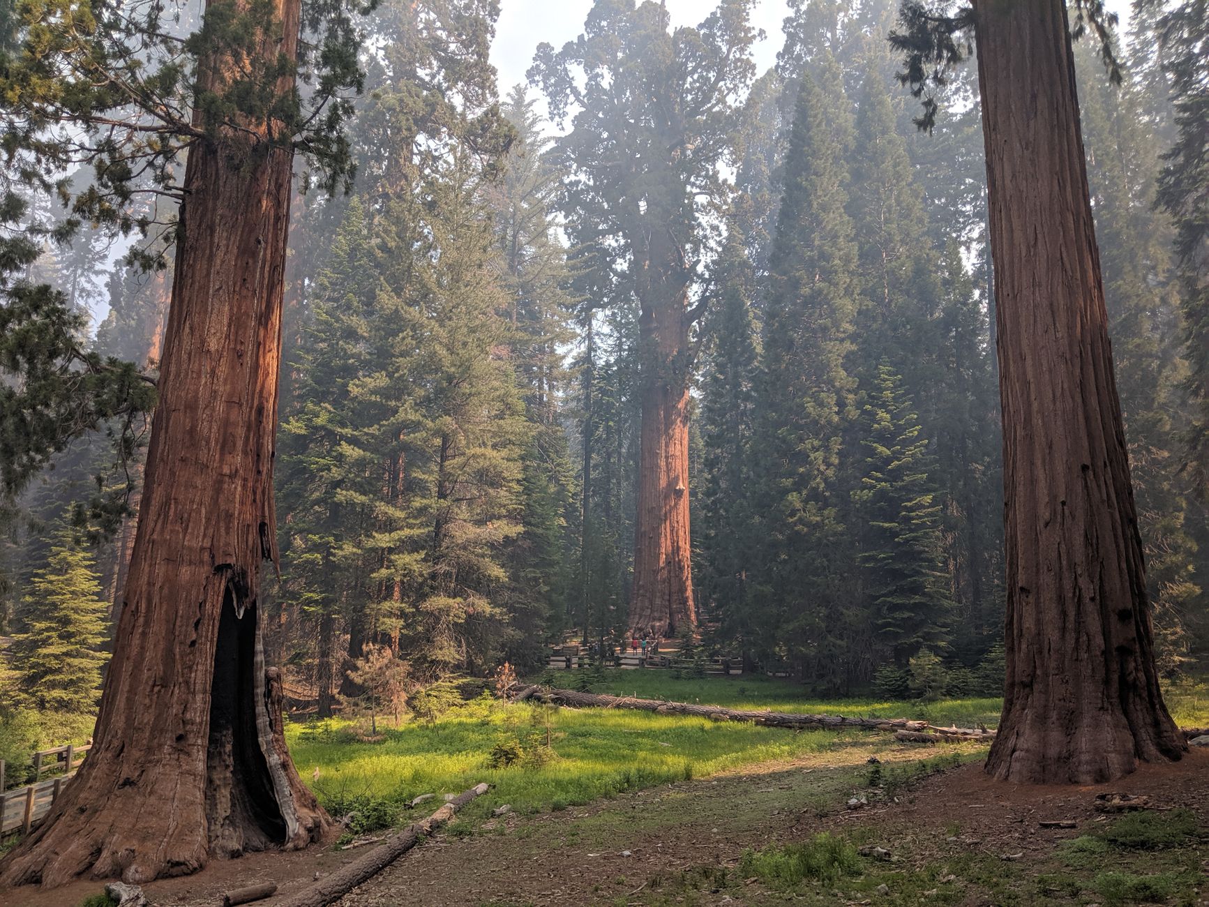

Sequoia National Park contains the largest tree on Earth by volume, and it is reached by a paved path a few hundred yards long.
That combination, a staggering natural object immediately accessible, is what makes the park so popular and what makes a badly planned day here so frustrating. The Giant Forest area is small, the road in is slow and winding, the parking is finite, and in summer the whole thing bottlenecks.
The fix is not complicated. It is a shuttle bus, and most people drive past it.
The road is the first problem
Generals Highway climbs from the Ash Mountain entrance near Three Rivers at around 1,700 feet to the Giant Forest at about 6,400 feet, and it does so in a series of tight switchbacks that take far longer than the mileage suggests. Budget an hour or more from the entrance to Giant Forest, and considerably more in summer traffic.
It also carries vehicle length restrictions, which is the part people discover at the entrance station rather than at home. Vehicles must not exceed 40 feet, and anything longer than 22 feet is not recommended on the stretch between Potwisha Campground and the Giant Forest Museum, which is a genuine constraint for anyone in an RV or towing. Guidepole Hike carries road restrictions and current access status alongside the trailheads they serve, and a length limit that turns a rental RV around at the gate is exactly the kind of thing worth knowing before the drive up rather than at the top of it.
Use the shuttle
In peak season the park runs free shuttles every 15 minutes between 8am and 6pm, and this is the single highest-value piece of information for a Sequoia day. Park once, at the Giant Forest Museum or a designated lot, and ride between the General Sherman Tree, Moro Rock, Crescent Meadow and the museum, which stops you competing for the small lots at each destination. That competition is where the day otherwise goes.
The Moro Rock and Crescent Meadow road in particular has very limited parking and is sometimes closed to private vehicles at peak times specifically because the shuttle serves it. Check current shuttle operating dates before relying on it, since the season varies.
The Congress Trail, Moro Rock, General Sherman and Crescent MeadowThe General Sherman Tree
The headline, and it earns it. General Sherman is the largest living single-stem tree on Earth measured by trunk volume, which is not the tallest, since that is a coast redwood, and not the widest, but the greatest bulk of wood in one organism. It is roughly 275 feet tall with a base circumference over 100 feet, and estimates put its age at something over two thousand years.
There are two ways to reach it. The main trail descends about half a mile from the upper parking area, which means climbing back up at around 6,900 feet, and while that is modest, people underestimate it at that elevation. The accessible route parks at a small area on Generals Highway about two miles north of the Giant Forest Museum and reaches the tree and the Congress Trail on level ground, and the free shuttle also serves that trailhead.
Go early or late, because midday in July is a line for a photograph.
The Congress Trail: where the crowd disappears
This is the recommendation that changes a Sequoia day. The Congress Trail is a roughly two-mile paved loop starting at General Sherman, taking you through the heart of the Giant Forest past the House and Senate groups, dense clusters of enormous sequoias standing together, and the President and McKinley trees.
The crowd at Sherman thins within a few hundred yards, because most visitors photograph the famous tree and return to the car, which leaves the loop that begins at its base comparatively quiet. Walking among a grove of them rather than looking at one is a completely different experience, since the scale only registers when they surround you. At two miles and paved, it is accessible to almost anyone.
Moro Rock
A granite dome with a staircase of roughly 350 steps cut into and built onto it in the 1930s, climbing to a summit with a view over the Great Western Divide and, on a clear day, down to the San Joaquin Valley. The view east into the high Sierra is the best roadside panorama in the park.
It is short, at a quarter mile, and it is exposed, with railings but with real drops beside the steps, so it is not for anyone uncomfortable with heights and it closes in ice. Access is via the Moro Rock to Crescent Meadow Road, which is where the shuttle earns its keep.
The rest of a day, and the rest of the park
Crescent Meadow, which John Muir called the gem of the Sierra, is a flat loop of under two miles through a meadow ringed by sequoias, with a good chance of black bears in the early morning or evening, and it is where the Sherman-and-Moro crowds are not. Tharp's Log, a hollowed fallen sequoia that a nineteenth-century cattleman lived in, sits on the loop. Nearby, Tunnel Log is a fallen sequoia with a hole cut through it that you can drive a car through, which is exactly as odd as it sounds and remains popular, and the Giant Forest Museum is a good small museum explaining what these trees are and why they only grow here.
Tokopah Falls from Lodgepole is about 3.4 miles round trip along the Marble Fork of the Kaweah to a 1,200-foot cascade below granite cliffs, and it is the best moderate hike in the park that has nothing to do with big trees. Lodgepole itself is worth knowing about as the practical center of the park, sitting a few miles north of the Giant Forest with the largest campground, a market, a visitor center and the closest thing to services inside the boundary. It is also a shuttle stop, which makes it a workable place to leave the car for the day if the Giant Forest Museum lot has already filled by the time you arrive.
Crystal Cave is the wildcard. It is a marble cavern in the Cascade Creek drainage, one of more than two hundred known caves in the park, with guided tours reached by a narrow winding road below the Giant Forest. Tickets are not sold at the cave and must be bought in advance, and both the access road and the cave itself have been closed for extended periods after fire and storm damage, so check its status before building a day around it.
Two things sit inside park boundaries that you cannot reach from here. Mount Whitney, at 14,505 feet the highest point in the lower 48, is technically inside Sequoia National Park, but its trailhead is on the far eastern side of the Sierra near Lone Pine, a five-hour drive around the range, because there is no road across. And Kings Canyon National Park shares an entrance and is administered jointly, with General Grant Grove thirty minutes north of the Giant Forest holding the second-largest tree on earth with a fraction of the visitors, while the canyon itself down the Highway 180 spur is one of the deepest in North America and is a separate day.
Hiking the Congress Trail in Sequoia National ParkWhy they only grow here, and what fire did
Giant sequoias grow naturally in about 70 groves, all on the western slope of the Sierra Nevada, in a narrow elevation band roughly between 5,000 and 8,000 feet, and nowhere else on Earth. They need the specific combination this slope provides: deep winter snowpack that melts slowly into summer, warm dry summers, and fire. Sequoia cones are largely serotinous, relying on heat to open and release seed, and the seedlings need bare mineral soil and light, which fire creates.
A century of fire suppression was therefore actively bad for them, leaving the groves with far more dense understory fuel than they evolved with. The consequences arrived recently and severely. The Castle Fire in 2020 and the KNP Complex and Windy fires in 2021 killed an estimated thirteen to nineteen percent of all large giant sequoias on earth, a loss with no precedent in the recorded history of the species, and the General Sherman Tree itself was wrapped in fire-resistant foil during the KNP Complex as flames reached the Giant Forest.
What you will see of that is threefold: prescribed burn scars through the Giant Forest, which are deliberate and are the reason that grove survived; blackened bark low on many trunks, which is normal and healthy rather than damage; and, on the drives in and out, hillsides of dead conifers from fire and drought. The park has burned intentionally in the Giant Forest since the 1960s, one of the earliest prescribed fire programs in the National Park Service, and the contrast between treated and untreated groves after 2021 was stark enough to reshape policy across the Sierra.
The gear
Sequoia's difficulty is the road rather than the trails, and the gear list starts there.
Layers for a five-thousand-foot climb, because the Generals Highway takes you from foothills at fifteen hundred feet to the Giant Forest at sixty-four hundred in about twenty miles. Ninety degrees at the entrance station and fifty-five among the trees is normal, and people arrive in shorts.
Tire chains in winter, which is a legal requirement rather than a suggestion. Chain controls go up on the Generals Highway regularly from November through April, they are enforced at the gate, and a vehicle without chains is turned around.
An America the Beautiful pass.
Water for the elevation, since sixty-four hundred feet is high enough to dry you out faster than you notice.
Shoes with grip for Moro Rock, whose staircase is carved into granite with a handrail and gets slick with any moisture at all.
Bear-proof storage discipline, meaning food in the lockers rather than in the car. The bears in the Giant Forest are practiced at vehicles.
And an offline map with the shuttle times downloaded, since the free summer shuttle is the sensible way to do this park, the Giant Forest lots fill by mid-morning, and there is no coverage to look up the schedule once you are there.
Season and conditions
Late spring to early autumn is the main window, with everything open and the shuttle running. Summer is busiest, and the elevation means Giant Forest at 6,400 feet is markedly cooler than the foothills, which is a genuine relief when the San Joaquin Valley is at 100°F. Autumn is quieter, clear and excellent.
Winter transforms the place. Sequoias under snow is one of the great sights in American parks and it is far less visited, though chains are frequently required on Generals Highway, some roads close, and the shuttle does not run. Smoke is a real consideration in late summer, as everywhere in California.
Practical notes
There is an entrance fee, covering both Sequoia and Kings Canyon, which are administered together. Bears are common and active, and food storage rules are strict and enforced, so use the lockers and do not leave anything scented in a vehicle, because Sequoia has a long history of bears breaking into cars.
Fuel up in Three Rivers, since services inside the park are limited, and expect cell signal to be poor to absent. Dogs are not permitted on trails. And the elevation is higher than people expect, because Giant Forest at 6,400 feet affects visitors arriving from the valley floor, and the walk back up from General Sherman is where they notice.
Park once, then keep walking
Get in early, park once at the Giant Forest Museum, and use the free shuttle for everything. See General Sherman, then keep walking onto the Congress Trail, which is where the crowd stops and the actual experience starts.
Add Moro Rock for the view and Crescent Meadow if you have time. Check the vehicle length limits before you drive up in anything large.
And spend a moment on the fact that these things only grow on one slope of one mountain range, in a band a few thousand feet wide, and that they need fire to reproduce.
California's other marquee park is north over the crest: one day in Yosemite, or three days there if you have them. The eastern side of this same range is covered in Eastern Sierra day hikes, and the high lakes and rivers of both parks in fly fishing Sequoia and Kings Canyon.
The other California park with the same crowding and the same solution is in one day in Yosemite and three days in Yosemite. The high country on the far side of the same range is in Eastern Sierra day hikes and Mount Whitney as a day hike, which is closer to here than the map suggests and much further by road. The nearest big city trail system is in hiking Los Angeles.
And a note on the name confusion, because it wastes people's time. Sequoia and Kings Canyon are two parks administered jointly, sharing an entrance fee, a road and a headquarters, and most of what a one-day visitor does is in Sequoia. Grant Grove, which holds the General Grant Tree, is in Kings Canyon but sits only a few miles up the Generals Highway from the Giant Forest, so it is an easy addition. Cedar Grove, the part of Kings Canyon that looks like Yosemite Valley, is two hours further and is a different trip entirely.