Fish
Fish Fire
Fire Hike
Hike Bird
Bird

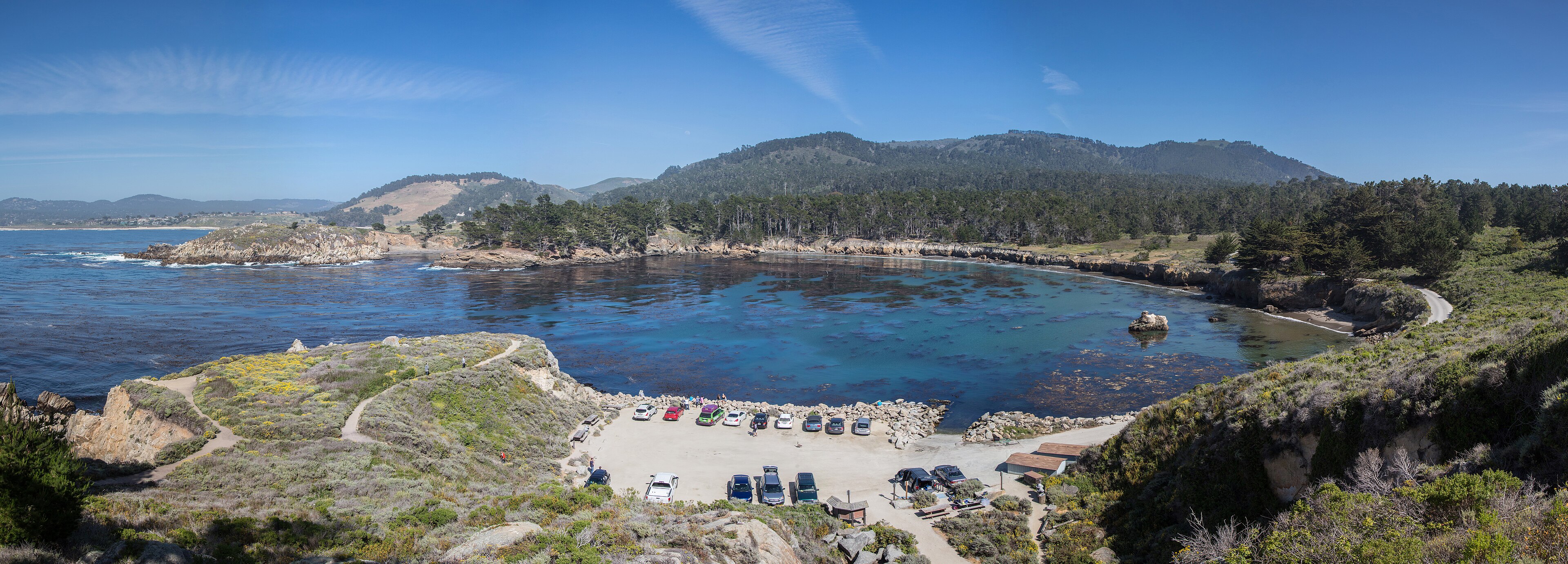

Point Lobos is not a state park. It is a State Natural Reserve, and after a while on the ground the distinction stops being bureaucratic and starts being obvious.
The trails are narrow. The signage tells you to stay on them. Dogs are banned entirely. The parking is deliberately limited. A reservation system covering every visitor, pedestrians included, has been proposed but is not yet in effect, so entry remains first come, with a vehicle day-use fee.
That is what a reserve is: a place managed so that a specific thing survives, with visitors accommodated only to the extent that they do not threaten it. The specific thing, in this case, is exceptional.
The cypress
Monterey cypress, Hesperocyparis macrocarpa, is one of the most widely planted ornamental trees in the temperate world, and you will find it in New Zealand, Australia, Britain and along coastlines everywhere.
In the wild it exists in two naturally occurring groves, both on this stretch of the Monterey Peninsula. One is at Cypress Point on the 17-Mile Drive. The other is here, at the Allan Memorial Grove on Point Lobos. That is the entire native range of the species: a few hundred acres of headland.
The trees are wind-sculpted, gnarled, and often draped in a bright orange alga called Trentepohlia, which people routinely mistake for rust or disease and which is harmless. They are also, in this native setting, under threat from pathogens, from fire, and from the simple fragility of a species reduced to two stands.
The reserve, and the reservation system
Point Lobos was acquired by the state in 1933, assembled partly through the Save the Redwoods League, and it has been managed restrictively from early on. In 1960 it added an underwater reserve, the first in the United States, extending protection below the waterline, which was a novel idea at the time and is now the model for marine protected areas worldwide. The kelp forest offshore is among the richest on the California coast, and Point Lobos is a well-known diving site, by permit.
Overuse has been the reserve's defining problem for years. The parking lot is small, so cars lined up along Highway 1, and pedestrians walked in from the shoulder in numbers that the trail network was never built for. The proposed response is a reservation requirement covering all visitors including those on foot, and it has been discussed and reported for years, but it is not yet in force: general entry is still first come, and only school groups and commercial tour buses currently need a reservation. Check the reserve's official page before traveling, because this is the arrangement most likely to change.
The rules that come with it are stricter than any California state park and they are absolute rather than advisory: no dogs anywhere in the reserve, stay on the trails because the ground either side is the reason the reserve exists, no collecting of anything including shells and rocks, and no drones. A day-use parking fee applies and a Golden Poppy annual pass at $125 covers most California state park day use, while diving requires a separate permit and is capped.
It is worth understanding why rather than resenting it, because a reserve with a hard capacity limit is doing the thing a reserve exists to do. It is also worth knowing that "reserve" is a specific designation rather than a synonym for park, and that the state park half an hour up the road permits things this ground does not. Guidepole Hike carries the designation and its rules against each site, which along a coast that mixes reserves, state parks and unsigned free ones within a few miles is the difference between arriving with a reservation and arriving with a dog.
The walking
The trail network is roughly six or seven miles in total, none of it long, all of it good, because the reserve is small and the density of interest is extraordinary.
Cypress Grove Trail is the essential one, a short loop under a mile through the Allan Memorial Grove out onto the headland, among trees that exist wild in only one other place. Sea Lion Point Trail is short, reaching the rocks where sea lions haul out and bark constantly. Bird Island Trail goes south to China Cove and Gibson Beach, past an island covered in nesting Brandt's cormorants in spring, with water in the coves a color that looks artificial.
The North Shore Trail runs the reserve's exposed northern edge with the best cliff scenery, and the South Shore Trail runs the tide-pool side. Whalers Cove holds the historic Whalers Cabin, now a small museum and the diving access point, and Granite Point and Moss Cove are the quieter northeastern corner.
A thorough visit walking most of the network is a half day, and it is one of the best half days in California.
The wildlife
Dense, close and reliable. Sea otters float on their backs in the kelp beds, often visible from the trail. Harbor seals pup in the coves in spring, which closes some beach access, and sea lions at Sea Lion Point are audible from most of the reserve. Gray whales pass close inshore on migration from December to May, and Brandt's cormorants nest on Bird Island in spring in dense colonies.
On land, black-tailed deer work the headlands with bobcats occasionally, and the tide pools on the south shore are worth timing for low water. This is a place to move slowly and look, which the reserve's small size encourages.
The kelp forest
Half of Point Lobos is underwater, and the reason it was worth protecting in 1960 is a forest. Giant kelp grows in dense stands offshore, anchored to rock and reaching the surface, in some conditions growing up to two feet a day, and the canopy shades a three-dimensional habitat that functions much like a terrestrial forest, supporting rockfish, lingcod, cabezon, sea stars, abalone and hundreds of invertebrate species.
Sea otters are the reason it persists. Otters eat sea urchins, urchins eat kelp holdfasts, and where otters were hunted out during the fur trade, urchin populations exploded and grazed kelp forests down to bare rock, producing what are called urchin barrens. The recovery of the California sea otter is directly linked to the recovery of the kelp, which makes this one of the textbook examples of a keystone species, and Point Lobos is one of the places the concept was worked out.
Watching an otter float on its back cracking a shell on its chest is therefore not just charming. It is the mechanism keeping the forest you are looking at alive.
The whaling and abalone history
Whalers Cove is named literally, and the layers of use there are unusually well documented. Chinese fishermen settled the cove in the 1850s, building the cabin that still stands and working the abalone and fish, drying and shipping their catch as one of a network of Chinese fishing communities along the California coast.
Portuguese whalers from the Azores operated shore-based whaling here from the 1860s, taking gray and humpback whales from small boats launched off the beach and processing them on the shore, which was brutal, dangerous work that left the cove littered with bone. An abalone cannery followed around the turn of the century, run by Japanese divers using hard-hat equipment, supplying a market that eventually collapsed as the abalone did. A granite quarry operated on the point, and coal was mined nearby.
So the reserve that now bans dogs and requires reservations spent seventy years as an industrial site, and the cabin at Whalers Cove has housed Chinese fishermen, Portuguese whalers, Japanese divers, and finally park staff. The whale bones you may see displayed there are from that period.
Point Lobos State Natural Reserve: Four of the Best TrailsThe painters and photographers
Point Lobos has a disproportionate place in American art, and knowing it changes how you look at the headlands. Edward Weston photographed here extensively from the 1920s, and the Point Lobos rocks, kelp and cypress are among his best-known subjects, since he lived in Carmel Highlands nearby and returned repeatedly for two decades. Ansel Adams worked here too, and the reserve appears throughout the Group f/64 circle's output.
Francis McComas, the watercolorist, gave the place the phrase about the greatest meeting of land and water in the world, which has stuck for a century because it is difficult to argue with, and Robinson Jeffers, the poet, lived and wrote in Carmel and drew heavily on this coast.
What drew them is still there and it is specific: extremely high contrast between white granite, dark cypress and turquoise water, combined with fog that flattens and softens on demand. The practical upshot for a visitor with a camera is that almost every composition here has been made before, well, by someone very good. That is either intimidating or liberating, and either way the light in the two hours after dawn is when the reserve looks like the pictures.
The gear
Point Lobos is a natural reserve rather than a park, and the difference shows up in the rules more than in the gear.
An early arrival, because the lot is small, capped at 150 vehicles, and fills by mid-morning. The alternative is parking on Highway 1 and walking in, which is legal, free and adds a mile.
Binoculars, which are as close to essential as anything here. Sea otters, harbor seals, sea lions, gray whales in season and an enormous seabird presence are all visible from the trails, and this is one of the better places on the California coast to watch any of them.
Layers for fog, since Monterey Bay produces it reliably and the temperature difference between fog and sun here is substantial.
A tide table, for the tidepools at Weston Beach, which are the best on this stretch of coast at low water and unremarkable at high.
Food from Carmel, because there is none in the reserve.
A Golden Poppy pass if you use California state parks regularly.
And the discipline to stay on trail, which is the actual rule of this place. Point Lobos is a reserve, the vegetation off trail is fragile and slow to recover, and the staff are not being fussy: the whole point of the designation is that this is a place being protected rather than a park being used.
Where it sits on the coast
Point Lobos marks a transition, and the drive either side of it explains why it is where it is. North of the reserve is Carmel, Monterey and the peninsula: developed, sheltered, and shaped by Monterey Bay. South of it, Highway 1 enters Big Sur, where the Santa Lucia Range drops straight into the Pacific for ninety miles with almost no flat ground and very little development.
Point Lobos sits exactly at the hinge, which is why the geology and the exposure change so noticeably within the reserve itself, and the sheltered northeastern coves at Whalers and Bluefish are a different world from the open western headlands taking the full swell.
Big Sur's own state parks are the natural continuation, meaning Andrew Molera, Pfeiffer Big Sur and Julia Pfeiffer Burns with its waterfall onto a beach, though Highway 1 through Big Sur closes regularly for landslides, sometimes for a year or more at a stretch, which is worth checking before planning any route that continues south. And Garrapata State Park, a few miles south of Point Lobos, is the underrated one: free, unsigned, with bluff trails and a calla lily valley, and no reservation system.
Ten Tips for Visiting Point Lobos State Natural ReserveSeason
Spring is the best overall, with cormorants nesting, seals pupping, wildflowers on the headlands and whales still passing. Winter brings dramatic surf and gray whales with the fewest people, autumn is often the clearest weather since the summer fog has retreated, and summer is foggy in the mornings, busy and cool.
The fog is a genuine feature here and part of why the cypress survive, because they draw moisture from it directly. Practically, the reserve is a few minutes south of Carmel on Highway 1 and about two hours from San Francisco, with minimal facilities and no food.
Why the rules
Because a few hundred acres of headland hold half the wild population of a tree species, a marine reserve that pioneered the concept in America, and a coastline that has been drawing painters and photographers for over a century, all within a two-hour drive of seven million people.
The proposed reservation system is the newest expression of a management approach that has been consistent here since the 1930s. Point Lobos has never been run for volume.
Go early, walk slowly, and leave the dog at home.
What a reserve designation means is explained in natural area, scenic trail, reserve, and California's restrictive dog rules in the state parks that want your dog. The Bay Area's network is in hiking the San Francisco Bay Area, and the fee comparison is in six states, six ways to charge you for a trailhead.
The redwood parks north of here are in Big Basin after the fire and Humboldt Redwoods. The nearest urban trail network is in hiking the San Francisco Bay Area. What a natural reserve designation commits to is explained in state natural areas explained, and the pass situation is in state park passes by state.