Fish
Fish Fire
Fire Hike
Hike Bird
Bird

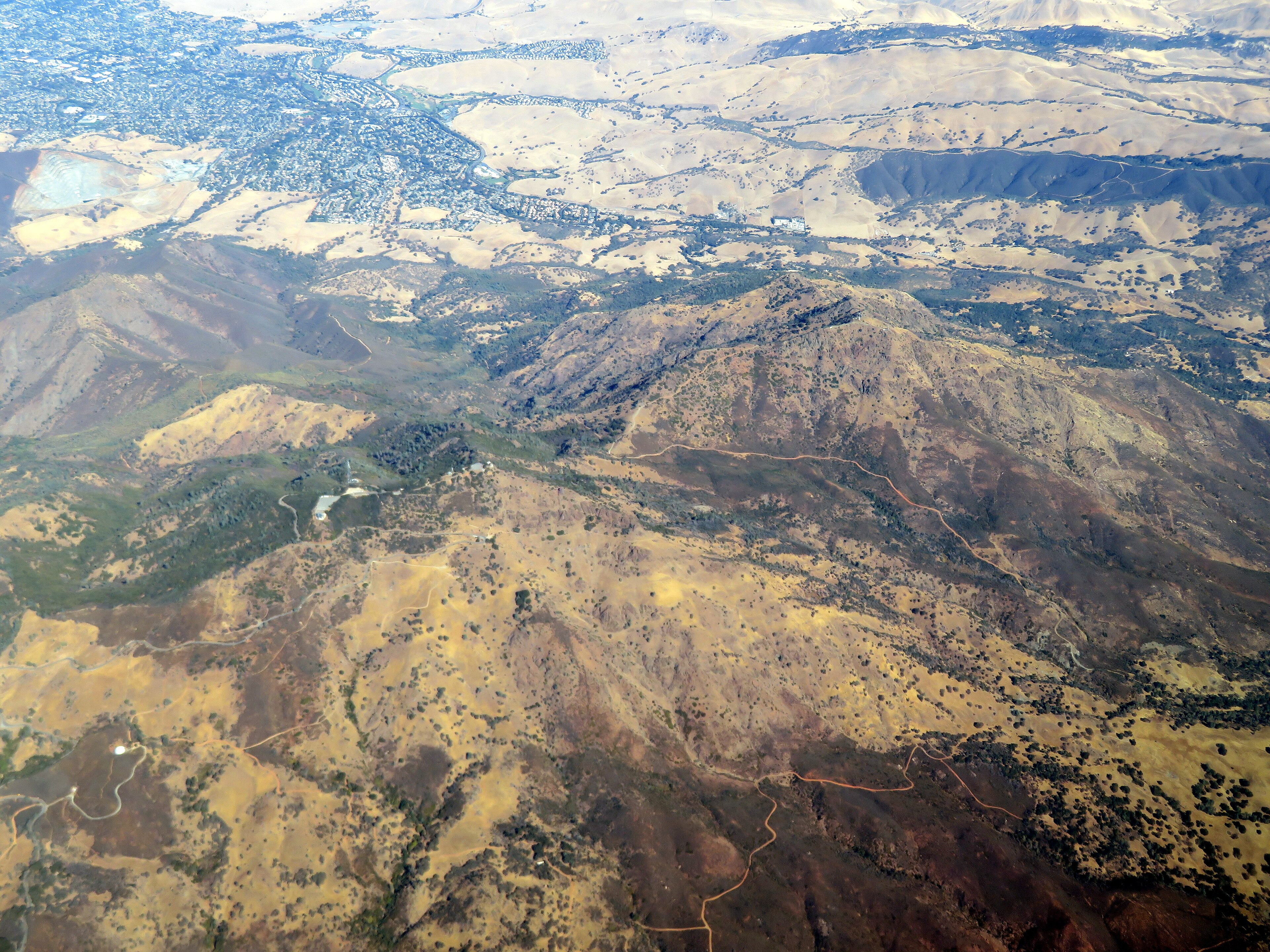

Mount Diablo is 3,849 feet, which by California standards is nothing. Half a dozen Bay Area hills are within a thousand feet of it.
What it has instead is isolation. It stands alone at the eastern edge of the Bay Area, with the flat Central Valley on one side and nothing of comparable height between it and the Sierra Nevada a hundred miles east.
The claim, made repeatedly since the nineteenth century, is that the summit commands one of the largest viewsheds of any peak on Earth, second only to Kilimanjaro. That claim is dubious as stated. What is not in dispute is that on a clear winter day, after a storm, you can see the Farallon Islands thirty miles into the Pacific, Mount Lassen 180 miles north, the Sierra crest including Half Dome, and a very large fraction of northern California.
Why it stands alone
Diablo is not a volcano and it is not a simple fold. It is a structural dome, a mass of rock pushed upward and outward by compression along the faults at the edge of the Central Valley, with older rock forced up through younger layers around it.
The result is that the mountain exposes an unusually complete and jumbled geological record. The oldest rocks at the core are ophiolite, fragments of oceanic crust and mantle, and around them sit marine sediments that were folded and tilted as the dome rose. It is still rising, by a few millimeters a year.
That structure also explains the Rock City area on the southern side, where wind and water have hollowed the tilted sandstone into caves, hollows and honeycomb weathering, with formations named Sentinel Rock, Elephant Rock and Wind Caves.
The Mount Diablo Base and Meridian
One important fact that almost nobody who climbs it knows. In 1851 the summit was chosen as the initial point for the survey of most of California and all of Nevada, and the Mount Diablo Base and Meridian is the origin of the township and range grid used to describe land across that entire area.
Every property description, every section line, and a great deal of the road grid across two states is measured from a brass marker on this summit. It is one of only thirty-seven such initial points in the United States, and it is the reason a mountain that is not especially high has been surveyed, mapped and marked continuously since the middle of the nineteenth century.
The summit
You can drive up. A paved road climbs from both the north and south gates to a parking area just below the top, and a stone summit building houses a visitor center with the marker and an observation deck. The building was built by the Civilian Conservation Corps in the 1930s from sandstone quarried on the mountain, and it is a good example of the rustic parkitecture style.
Or you can walk, and the classic climbs are long. Mitchell Canyon to the summit from the north side is roughly 13 to 14 miles round trip with about 3,200 feet of gain and it is the standard hard day, with the lower canyon gentle and the upper section relentless. The Grand Loop circles the summit area at around 6 to 7 miles with 2,000 feet, taking in Eagle Peak or the North Peak country, while the Juniper Trail and Summit Trail give a shorter climb from the upper ranger station.
For alternatives, North Peak at 3,557 feet is the second summit and considerably quieter, Eagle Peak from Mitchell Canyon is a strenuous shorter option with excellent views, and Rock City and the Sentinel Rock area on the south side are short walks with scrambling and caves, which makes them the best family option in the park.
The name, and the story behind it
The mountain is not named after the devil in the way most people assume. The accepted account is that in 1805 Spanish soldiers surrounded a group of Chupcan people in a willow thicket near modern Concord, and overnight the Chupcan escaped, apparently without being seen, so the Spanish called the place Monte del Diablo, thicket of the devil, meaning the thicket where something inexplicable happened. Monte in that usage means thicket or woodland rather than mountain.
American surveyors later transferred the name to the peak on the horizon and translated monte as mountain, producing Mount Diablo. There have been repeated campaigns to rename it, most often to Mount Kawukum or another Indigenous name, and they have not succeeded. The Volvon, Chupcan, Bay Miwok and other groups lived around the mountain, and it holds significance in the creation narratives of several peoples of the region.
Fire, and what changed in 2013
In September 2013 the Morgan Fire burned around 3,100 acres on the mountain's eastern flank, and what followed is one of the better-documented fire-following wildflower events in California. Chaparral species whose seeds require heat or smoke to germinate produced an extraordinary bloom the following spring, including whispering bells, fire poppies and species that had not been recorded on the mountain in decades.
Fire poppies in particular are effectively invisible between fires, because the seed bank sits in the soil for years or decades waiting for a burn. The 2014 display drew botanists and photographers from across the state and produced new records for the park.
It is a useful corrective to the way fire is usually discussed. The chaparral on Diablo is a fire-adapted system that burns on a natural cycle measured in decades, and the vegetation is arranged around that. What is not natural is the frequency change, because too-frequent fire converts chaparral to non-native grassland, which is the actual risk on this mountain rather than the fires themselves.
Heat is the constraint
This is the thing that catches people. Mount Diablo in summer is dangerous, because inland East Bay temperatures regularly exceed 100°F, the mountain is grassland and chaparral with almost no shade, and there is no water on the trails. Rescues from Diablo in summer are routine, and the park closes trails during extreme heat.
So the season is November through May. Spring is the best of it, specifically March and April, when the wildflower display is outstanding and Diablo's rich endemic flora is out, including the Mount Diablo globe lily and Mount Diablo fairy lantern, which grow nowhere else. Winter after a storm is when you get the view, so it is worth watching the forecast and going the day after a front clears. Autumn is warm and clear but flowerless.
Mount Diablo State Park: Summit Views, Rock City and WildflowersThe beacon
On the summit building sits an aviation beacon with a specific history. It was installed in 1928 as part of a network of lighted airway beacons guiding early transcontinental airmail flights, and it was reportedly dedicated by Charles Lindbergh.
It was extinguished on December 8, 1941, the day after the attack on Pearl Harbor, along with beacons across the west coast, for fear of guiding enemy aircraft. It stayed dark until 1964, when it was relit for a single night at the request of veterans, and it has been lit every December 7 since, in memory of Pearl Harbor, with surviving veterans of the attack attending the ceremony over the years in declining numbers.
It is visible for an enormous distance on that one night of the year, which given the mountain's viewshed is the point.
The gear
Mount Diablo is a thirty-eight-hundred-foot peak rising straight out of the East Bay suburbs, and the gear list is a hot-and-dry list.
All your water, because there is very little on the mountain and the climbs are exposed grassland and chaparral. Summer here runs past a hundred and the rescues are heat.
Binoculars, for the view, which on a clear winter day after a storm is one of the largest unobstructed views on earth: the Sierra crest to the east and the Farallones to the west, which people repeat as trivia and which is actually true.
A post-storm forecast check, since that view exists on perhaps a dozen days a year, all of them in winter, all of them the day after rain has scrubbed the valley haze out.
Sun protection, for a mountain with essentially no shade.
Tick and rattlesnake awareness, both of which are routine here. Ticks in the spring grass and rattlesnakes on the warm rock through summer.
Trekking poles, for descents on loose fire road, which is most of the trail network.
And a wildflower guide in spring, because the serpentine and grassland bloom here is one of the better ones in the Bay Area and the window is short.
The mountain's other users
Diablo is shared, and knowing who else is out there makes the day smoother. Cyclists climb the summit road in numbers, and it is one of the classic road climbs in northern California at around eleven miles and 3,200 feet from either gate, so expect them on every bend, in both directions, often descending fast. Mountain bikers use the fire roads extensively and Diablo has a long history in the sport, while trail runners are constant and the mountain hosts several long-standing races.
Beyond that, rock climbers work the sandstone at Rock City and Boy Scout Rocks, which is short, technical and historically significant in Bay Area climbing. Astronomers use the summit for its elevation above the marine layer, with public observing sessions run periodically. And hang gliders and paragliders launch from designated sites.
The practical version is that on a spring weekend the summit road is busy in every mode and the fire roads are shared, while weekday mornings are a completely different mountain.
Mount Diablo State Park: Rock City and the Summit TrailSave Mount Diablo
The park is 20,000 acres and the protected land around it is far larger, which is not an accident. Save Mount Diablo was founded in 1971, when the state park was around 6,800 acres and development was moving up the mountain from all sides.
Since then the organization and its partners have helped protect more than 100,000 acres across the wider Diablo range through purchases, easements and advocacy, creating a network of connected open space that includes state park, regional preserves, county land and water district holdings. That connectivity matters ecologically, because a single isolated peak surrounded by subdivision supports far less than a linked corridor does.
It matters practically too. Many of the best trails on and around Diablo are on land that is not state park, with different managers and different rules, and the boundaries are frequently unmarked, so a walk that starts on state park ground can finish on a water district parcel with a different position on dogs, bikes and hours. Guidepole Hike carries the managing agency and its rules under the trail, which on a mountain assembled from a hundred thousand acres of separate purchases is the layer that decides what you are allowed to do where you are standing.
What to do
If you want the view, drive up the day after a winter storm clears and take binoculars. If you want the hike, take Mitchell Canyon to the summit, thirteen miles, in March, starting at dawn. With children, go to Rock City for the caves and the scrambling. And if you want quiet, take North Peak, which almost nobody bothers with.
Practically: day-use parking fees apply at the entrance gates and a Golden Poppy annual pass at $125 covers most California day use. Camping at Juniper, Live Oak and Junction books ahead, and the sites at elevation are excellent. Dogs are restricted, as across California, largely to roads and campgrounds rather than trails. Carry all your water, because there is essentially none on the trails. Rattlesnakes are common on warm days, ticks are in the wet-season grass, and mountain lions are present. The summit road can close for snow a few days a year, which is a local event. And it is about 45 minutes from Oakland and an hour from San Francisco.
Once at the top, find the brass marker in the visitor center floor, and consider that the boundaries of nearly every property in California and Nevada are measured from the spot you are standing on.
The rest of the region is in hiking the San Francisco Bay Area and the harder backcountry at Henry Coe. California's other big parks are Anza-Borrego and Big Basin, and the fee rules are in six states, six ways to charge you for a trailhead.
The rest of the region's trail system is in hiking the San Francisco Bay Area, and the larger, wilder park an hour south is in Henry Coe. The coastal reserve down the peninsula is in Point Lobos, and the redwood park in the mountains west is in Big Basin after the fire. The pass structure is in state park passes by state.
And a word on the beacon, since it is the mountain's oddest feature. The aviation beacon on the summit was lit in 1928, went dark after Pearl Harbor for the duration of the war, and has been relit every December 7th since 1964 at sunset, for one night, by surviving veterans. It is visible across most of northern California. Almost nobody who sees it from a freeway knows what it is.