Fish
Fish Fire
Fire Hike
Hike Bird
Bird

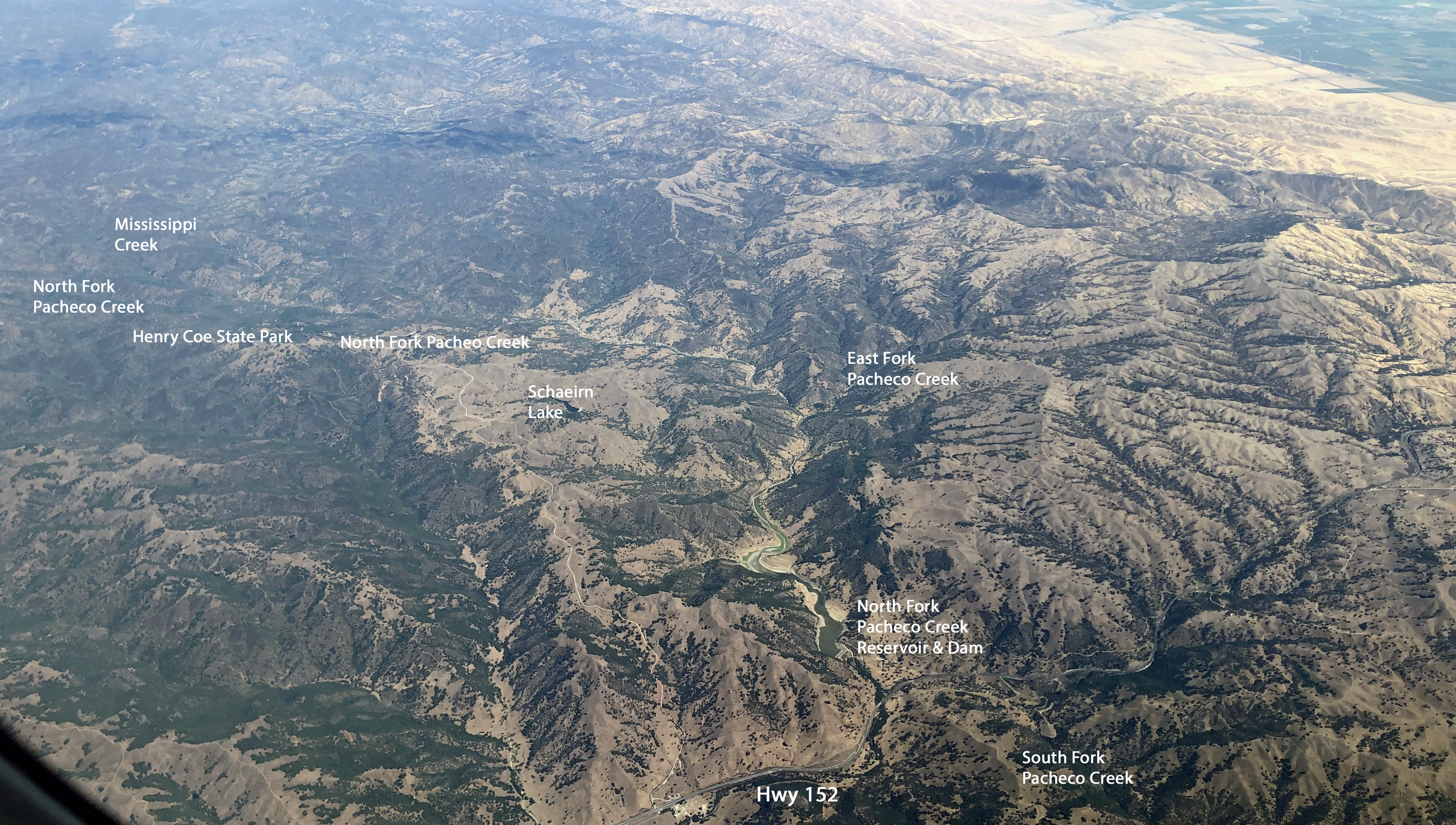

An hour from downtown San Jose there is a state park of 87,000 acres with more than 250 miles of trail, no through roads, and stretches where the nearest reliable water is several miles and two thousand vertical feet away.
Henry W. Coe State Park is the largest state park in northern California and the second largest in the state. It contains a designated wilderness area of its own. It has a permanent staffing and funding problem, it nearly closed in 2012, and it is kept going substantially by volunteers.
It is also, for anyone who wants genuine backcountry within reach of the Bay Area, the answer.
What makes it hard
This needs saying at the top, because Coe has a reputation and it is earned. The trails are old ranch roads, and this was cattle country, where ranch roads do not switchback: they go straight up the ridge and straight down the other side, so a four-mile section can involve two thousand feet of gain and two thousand feet of loss, repeatedly. The terrain compounds it, because the Diablo Range here is a series of parallel ridges and steep creek canyons, and any route across the grain climbs and drops constantly.
Water is the limiting factor. Springs and creeks are seasonal, the ponds are stock ponds, and in late summer and autumn much of the park is dry, so planning a route here starts with water rather than distance. It also gets extremely hot, with inland Diablo Range summers running well over 100°F and no shade on the ridges, and there is no signal across most of it.
The other hazards are the ordinary California set, all of them abundant here: mountain lions along with bobcats, coyotes and a large deer population, ticks through the grass in what is Lyme disease country, poison oak everywhere, and rattlesnakes on warm days.
People who arrive expecting a state park experience and leave describing the worst day of their hiking lives are a recurring feature of Coe's reputation. The park is honest about this.
The seasons decide everything
Late autumn through spring is the season, meaning November to May. Spring is the best of it, specifically March and April, when the hills are green, the creeks are running, the wildflower display is exceptional and the temperatures are workable. Winter is excellent for walking, being cool and green with the water problem largely solved, though access roads can be affected by storms.
Summer and early autumn are the wrong time, and not merely unpleasant: the combination of heat, absent water and long climbs is a genuine hazard, and rescues here are difficult.
Getting there and the entrances
The park has several entrances and they are different experiences. Coe Headquarters above Morgan Hill is the main one, reached by East Dunne Avenue, which climbs about eleven miles of narrow winding asphalt from the valley and takes longer than the distance suggests, and the visitor center, parking and most day-hike trailheads are here. From San Jose it is about an hour.
Hunting Hollow, on Gilroy Hot Springs Road south of the park, is the usual backpacking entrance and gives the most direct access to the southern and eastern country, with Coyote Creek nearby and similar. Dowdy Ranch, on the far eastern side reached from the Central Valley, is the closest entrance to the Orestimba and has very limited opening, and Bell Station on Highway 152 is a newer access point. The eastern entrances are considerably further round.
Check which entrances are open before traveling, because staffing constraints affect hours and some gates are seasonal. That is a real planning problem in a park this size, since which gate is open decides not just where you park but which half of 87,000 acres you can reach, and the answer changes with the season and the budget. Guidepole Hike carries entrance and trailhead access status against the routes they serve, which at Coe is the difference between a day in the Orestimba and a two-hour drive around the outside of the park.
Day-use parking fees apply, and a Golden Poppy pass at $125 covers most California day use. The visitor center at headquarters is volunteer-run and the staff there give the best route advice available. Dogs are restricted, as across the California system, and this is not a park for them regardless.
Where to start: the trails
From headquarters, the Monument Trail is a steep mile to a viewpoint and the Henry Coe monument, and Frog Lake is around 4.5 miles round trip, a manageable introduction with a pond at the end. Middle Ridge Loop is roughly 9 to 11 miles depending on route, the classic day hike and a serious one with substantial climbing. China Hole is about 10 miles round trip with 1,600 feet of loss on the way in, which means 1,600 feet of climbing at the end of a hot day, and while it is a beautiful swimming hole it has broken a lot of people.
The longer objectives sit east. The Orestimba Wilderness, in the park's remote eastern half, is a multi-day proposition, with Rooster Comb and the Mustang Peak country the classic destinations. Pacheco Falls, a long way in, is one of the better waterfalls in the Bay Area and almost nobody has seen it. And the Coe Backcountry Weekend, run annually in spring, opens gated roads and shuttles people deep into the park, which is the easiest way to reach the far country.
Backpacking here
Permits are required for overnight trips and have been obtained at the entrance stations, which is worth confirming with the park before you drive out, because a park this size runs on limited staffing and the station may not be open when you arrive. Camping is largely dispersed rather than at designated sites, which is unusual for California and one of the park's real attractions.
Water planning is the whole exercise, so know your sources, know their seasonality, carry a filter and carry more capacity than you would elsewhere. Fires are usually prohibited, so carry a stove. And the park is big enough to get lost in, with the road network on old maps not always matching the ground.
The wildflowers, which are the payoff
The reason to endure Coe's gradients in spring is a display that rivals anywhere in California. The park spans a large elevation range across varied soils, including serpentine, which produces an unusually long and diverse bloom.
February and March bring the early species at low elevation, including shooting stars, buttercups and milkmaids. April is the peak, with California poppy, lupine in several species, owl's clover, tidy tips, blue dicks and larkspur, and the grassland turning solid color across whole hillsides. May moves the display upward and brings mariposa lilies and clarkia. The serpentine areas hold specialists that tolerate the hostile soil chemistry and grow nowhere else nearby, and the park also holds one of the better displays of bush poppy and chaparral species after fire, since Coe burns periodically.
What makes the display unusual is scale. In a good year you can walk for hours through continuous flowers, across ridges nobody else is on, which is not an experience available in the more accessible Bay Area parks.
A Thirty-Two Mile Overnight Backpacking Trip in Henry CoeWhy it exists, and the ranching layer
Henry Willard Coe Jr. ranched here, and in 1953 his daughter Sada Coe Robinson donated the family's Pine Ridge Ranch to Santa Clara County in his memory. It transferred to the state and has been expanded repeatedly since, largely through acquisitions of neighboring ranches.
That history is why the trail network exists at all and why it is shaped the way it is, because Coe's roads were built to move cattle between water and grazing, which is exactly why routes climb ridges directly and why the ponds are where they are. Reading the park as a working ranch that has been left alone for seventy years makes it far more legible than reading it as wilderness.
The furniture repays attention on that basis. Stock ponds are everywhere, dug to water cattle and now the park's main summer water source for wildlife, used heavily by frogs, newts and dragonflies, with windmills standing at several of them and some still turning. Orchards survive at old homestead sites, so apple and walnut trees fruit in autumn in the middle of nowhere, and corrals, cabins and barns appear along the ridges. The Coe Ranch headquarters at the main entrance is the original ranch complex, with the visitor center in the old house.
Pigs are the ecological problem left over from all of it. Feral hogs, descended from escaped domestic stock and introduced European wild boar, root up large areas and are actively managed.
The gear
Henry Coe is the largest state park in northern California and the hardest hiking in this group, and the gear list says so plainly.
More water capacity than you own, which is not a joke. The park is eighty-seven thousand acres of steep chaparral and oak with almost no shade, the ponds are unreliable and seasonal, and summer temperatures run past a hundred. Six liters is a normal day here.
A filter, for the ponds when they are holding water, which they mostly are not from July onward.
A paper map, because the trail network is enormous, some routes are old ranch roads that come and go, and coverage in the interior is nil.
Tick protection and a check routine, since this is prime tick country and the grass in spring is full of them.
Poison oak wash, because it is everywhere here, and in a dry summer it is leafless and unrecognizable.
Trekking poles, for a park whose defining characteristic is that the ranchers who built the roads did not believe in switchbacks. The climbs here are straight up ridge lines.
And a conversation with the volunteers at headquarters, which is the most useful thing on this list. The park is staffed largely by the Pinnacles and Coe volunteer organizations, they know which ponds are holding water this month, and that information exists nowhere else.
The near-closure, and who keeps it open
Coe's story since 2011 explains a lot about how it feels on the ground. In 2011, facing a budget crisis, California announced the closure of seventy state parks, and Henry Coe was on the list. What followed was a local campaign that raised money, negotiated an operating agreement and kept the park open, with the Pine Ridge Association, the park's volunteer organization, taking on a substantially larger operational role than a friends group normally would.
Much of the visitor contact, the trail maintenance, the mapping and the education program at Coe is volunteer-delivered and has been for years. The practical consequences for a visitor are real, because staffing is thin, some entrances have limited hours, facilities are basic, and the information you get at headquarters comes from people who are there because they choose to be.
It also means the park has an unusually engaged constituency. The maps produced by the volunteers are better than the official ones, and the route advice is specific in a way that a seasonal ranger's would not be. If you enjoy Coe, the association is the reason it is open.
Backpacking Henry Coe and the Orestimba WildernessFishing the ponds
An odd feature worth knowing about. Coe's stock ponds hold bass, stocked historically for ranch use and self-sustaining since. Some of the more remote ponds, particularly in the Orestimba country and around Mississippi Lake, have a reputation among a small group of anglers who are willing to walk ten or more miles carrying a float tube to fish water almost nobody reaches.
Mississippi Lake in particular is legendary and remote, and reaching it is a genuine backpacking objective. A California fishing license is required and park regulations apply.
It is a strange thing, walking for hours through dry oak grassland to find a pond with bass in it, and it is very characteristic of what Coe is.
The honest recommendation
If you want a day hike, go in March or April, start early, do Frog Lake or Middle Ridge, and carry more water than the distance suggests.
If you want the real thing, go in winter or spring with a permit and two nights, and walk east into the Orestimba.
And if you have never hiked hard, this is not the place to start, because China Hole in July is how people end up in genuine trouble an hour from Silicon Valley.
The Bay Area's gentler options are in hiking the San Francisco Bay Area and Big Basin. California's other big empty park is Anza-Borrego, and the fee rules are in six states, six ways to charge you for a trailhead.
The nearest urban trail network is in hiking the San Francisco Bay Area, and the other big East Bay peak is in Mount Diablo. The desert park at the other end of the state is in Anza-Borrego. The heat reasoning here is the same as in hiking in wildfire smoke for the general habit of checking conditions, and the pass structure is in state park passes by state.
And a note on the near-closure, because it is the reason the park is the way it is. Henry Coe was on California's 2011 closure list, and it stayed open because a volunteer organization signed an operating agreement and took on much of the staffing. That is why the visitor center is run by volunteers, why the trail information is better than the signage, and why the place feels less managed than any other state park in this library. It is also why it is worth donating at the entrance.