Fish
Fish Fire
Fire Hike
Hike Bird
Bird


There is no gate. There is no visitor center, no fee booth, and no single place to park and start.
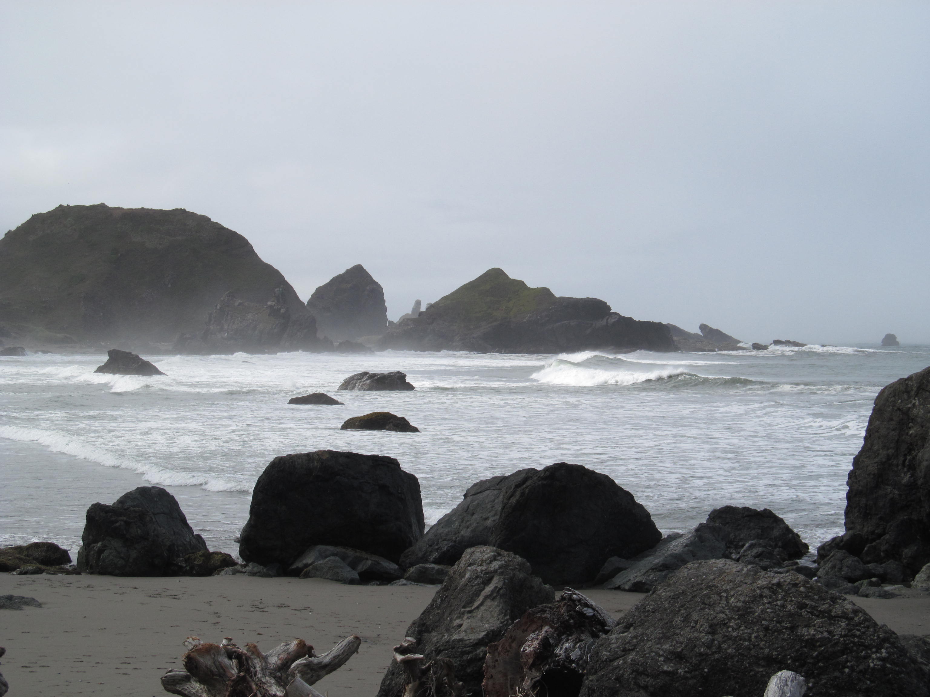
The Samuel H. Boardman State Scenic Corridor is a strip of protected land running along roughly twelve miles of Highway 101 between Brookings and Gold Beach, on the southern Oregon coast. You reach it through a series of unmarked-looking pullouts, and each one drops you into something different.
It is the best coastline in Oregon, and a large proportion of the people who drive through it never stop.
Who Samuel Boardman was
He was Oregon's first state parks superintendent, serving from 1929 to 1950, and the reason the state has the park system it does. Boardman spent two decades acquiring land along the coast and elsewhere, often aggressively, often on a shoestring, sometimes by persuading landowners to donate ground they had no idea anyone wanted, and the Oregon state park system expanded from a handful of sites to hundreds under him.
He was also central to the argument that the beaches should stay public, the principle that eventually produced the 1967 Beach Bill. The corridor was named for him in 1950, and it is a fitting monument: not a single grand park but a long thin string of pieces, acquired one at a time.
What is here
The corridor's structure means you plan by pullout, and these are the ones worth stopping at, roughly north to south. Arch Rock is the northernmost major viewpoint, a picnic area above sea stacks and an offshore arch with minimal walking. Natural Bridges is the most photographed thing in the corridor, a collapsed sea cave system leaving a series of rock arches over a cove, where the official viewpoint is a very short walk and the informal paths descending toward the arches are eroded, steep and dangerous, and people are injured on them.
Thunder Rock Cove is the parking area for the walk to Secret Beach, and Secret Beach itself is reached by about half a mile through dense coastal forest and down to a cove where a waterfall drops onto the sand at low tide, the single best short walk in the corridor and no longer remotely secret. Indian Sands is the strangest, a wind-sculpted area of exposed tan sandstone and dunes perched on the cliff top, reached on a short steep trail, and it looks like nowhere else on this coast.
Whaleshead Beach has a large sea stack with a blowhole that spouts in the right swell, House Rock and Cape Ferrelo are high grassy viewpoints and excellent for whale watching, and Lone Ranch Beach is the southernmost, a sheltered cove with tide pools.
The Oregon Coast Trail through here
The corridor carries one of the finest sections of the Oregon Coast Trail, and walking it connects the pullouts rather than treating them as separate stops. Roughly twelve miles of trail run the length of the corridor, climbing over headlands and dropping to coves, with the highway close by but usually out of sight. This is the way to see the place properly, because the pullouts give you postcards and the trail gives you the sequence.
Logistics are the problem, since it is a linear route beside a highway with no shuttle, so most people either walk a section out and back or arrange a car at each end. The tread is narrow, rooty, muddy in wet weather and locally steep, a proper coastal trail rather than a promenade. And some sections are eroding, because this coast is actively losing cliff and the trail is realigned periodically.
That last point is the practical case for checking current conditions rather than a guidebook. A ribbon assembled from separate acquisitions has no single authority page, the closures land on individual pullouts and trail segments rather than on the park as a whole, and a realignment after a winter slide can move where a section starts. Guidepole Hike carries closures and access against the specific segment, which on twelve miles of unsigned pullouts is the difference between finding the Secret Beach trailhead and driving past it twice.
The cliffs are not a metaphor
This needs stating plainly, because the corridor's beauty is directly tied to its danger. The viewpoints sit on high, undercut, actively eroding sea cliffs, the rock is not solid, and vegetation at the edge is often growing on overhanging material with nothing beneath it.
People have died here, including at Natural Bridges, going beyond the fences for a photograph. Stay behind the barriers, and where there are no barriers stay well back from the edge, and do not descend the informal paths at Natural Bridges. Sneaker waves on the beaches are the other hazard, and this stretch of coast is exposed to open Pacific swell with no shelter.
Why this coast looks different from the rest of Oregon
The southern Oregon coast is geologically distinct from the north, and it shows. North of about Coos Bay the headlands are mostly Columbia River Basalt, lava that traveled hundreds of miles from eastern Oregon and reached the sea sixteen million years ago, which produces the blocky dark capes of the north coast.
Down here the rock is older and stranger, a chaotic assemblage of sedimentary and metamorphic rock scraped off the ocean floor and jammed onto the continental margin over tens of millions of years. Geologists call this kind of mess an accretionary complex, and the Klamath Mountains behind the coast are made of it.
The practical result is more resistant rock, more offshore sea stacks, sharper headlands, and more arches and natural bridges than anywhere else in the state, because when softer material erodes out from between harder blocks you get exactly the sculpted coastline the corridor is famous for. The Klamath Mountains reaching the sea also explain the vegetation, since this region holds an unusual concentration of conifer species, some of them restricted to serpentine soils, and the botanical diversity of the Klamath-Siskiyou is internationally recognized. Sitka spruce dominates the wind-exposed headlands, shaped and stunted by salt.
The offshore rocks are a refuge
Every sea stack you look at is federally protected. The Oregon Islands National Wildlife Refuge covers roughly 1,850 rocks, reefs and islands along the entire Oregon coast, nearly all of them closed to landing, and from the Boardman corridor you are looking at dozens of them.
They support more than a million nesting seabirds: common murres in dense colonies, tufted puffins, pigeon guillemots, cormorants, storm petrels and gulls. Tufted puffins nest on a few of these rocks and are one of the harder Oregon birds to see, though the population has declined sharply. Steller and California sea lions and harbor seals haul out on the lower rocks.
The closures matter, because seabird colonies are extremely sensitive to disturbance and a single approach by boat or drone can flush an entire colony and cost a season's chicks. Drones are prohibited over the refuge, which includes essentially every rock visible from the corridor.
The Most Scenic Part of the Oregon Coast: Samuel H. BoardmanThe Wild Rivers Coast
The corridor sits in a stretch of southern Oregon that is marketed as the Wild Rivers Coast, and for once the branding is accurate. The Rogue River meets the sea at Gold Beach, at the corridor's northern end, and it was one of the original eight rivers protected under the Wild and Scenic Rivers Act of 1968, with jet boats running upriver from the town into a wild canyon. The Chetco enters at Brookings, at the southern end, and is famous for exceptionally clear water, while the Illinois and the Smith, just over the California line, complete the group.
What these rivers share is a steep, geologically complex and largely undeveloped catchment, which is why they run clear and cold in a region where most rivers do not, and the salmon and steelhead runs on the Rogue and Chetco are among the better remaining ones on the West Coast.
Redwoods reach their northern limit a few miles south of Brookings, in the Chetco valley, and Alfred A. Loeb State Park protects a stand of them alongside a myrtlewood grove. So within half an hour of the corridor you can be in the northernmost coast redwoods in the world, on one of the first Wild and Scenic Rivers, in the most botanically diverse conifer region in North America.
The gear
The Boardman corridor is twelve miles of headlands, sea stacks and pocket beaches strung along Highway 101, and the gear list is a coastal one with a warning in it.
Binoculars, for the sea stacks, which hold nesting seabirds through the summer, and for the gray whales that pass close inshore.
A tide table, because most of the beaches here are only reachable at low water and the routes down to them are not places to be caught by a rising tide.
Grippy footwear, since the trails down to the coves are steep, rooted and frequently wet.
A rain shell, for the wettest coast in the contiguous states.
Restraint near the edges, which is the item that matters. These headlands are undercut sandstone and mudstone with vegetation growing right to the lip, the ground at the edge is frequently not supported by anything, and the fatalities on this stretch of coast are overwhelmingly people who walked past a fence for a photograph.
A full tank, because the southern Oregon coast has long gaps between stations.
And a camera with reach, since the best subjects here, the arches and the stacks and the birds, are all offshore.
The tsunami question
This is worth knowing on any Oregon beach walk and it is rarely mentioned. The Cascadia Subduction Zone runs offshore along the entire Pacific Northwest coast and it produces very large earthquakes at intervals averaging several hundred years, and the last full-margin rupture was in January 1700, dated precisely because the tsunami it generated was recorded in Japan.
The practical rule for a visitor is that if you feel a long, rolling earthquake on the coast, do not wait for a warning. Move immediately to high ground or inland, on foot, and stay there, because a local tsunami can arrive within fifteen to twenty minutes, which is faster than any official alert can reach you. Tsunami evacuation routes are signed throughout coastal Oregon, including at the Boardman pullouts, and the blue signs with a wave symbol are worth registering as you park.
The corridor is well placed for this, because most of its viewpoints are already high on headlands, and the risk is on the beaches and in the coves, which is where you would naturally be. This is not a reason to avoid the coast. It is a reason to know, once, what to do.
Exploring the Samuel H. Boardman Scenic CorridorSeason, weather and practical notes
Summer brings the driest weather and the most people, though this corridor is never crowded by the standards of the northern Oregon coast. Spring is excellent, with wildflowers on the headland grasslands and gray whale migration, and autumn is the local secret, warm, often clear and empty, since September and October on the southern Oregon coast are frequently the best weather of the year. Winter is dramatic, wet and windy, with the best storm watching and the highest surf. Fog is common on summer mornings and can erase the entire point of the corridor for hours. As for whales, gray whales migrate south in December and January and north in March and April, and a resident group feeds off this coast through summer.
There is no fee at most of the corridor's pullouts, which is unusual for Oregon and a legacy of how the land was assembled. Facilities are minimal, with a few pullouts having toilets and most having nothing, and camping is not in the corridor, so Harris Beach State Park in Brookings is the nearest and it books six months ahead. Dogs are welcome on leash, and on the beaches Oregon's off-leash-under-control rule applies. Brookings has full services and the mildest winter climate on the Oregon coast, a genuine banana belt that gets warm easterly winds in autumn, signal is patchy along the corridor, and Highway 101 here is narrow and winding with pullouts that appear suddenly, so slow down.
How to do it
A drive-through in three hours is Arch Rock, Natural Bridges, Whaleshead and Cape Ferrelo. Half a day adds the walk to Secret Beach and the Indian Sands loop. A full day is a long section of the Oregon Coast Trail through the corridor with a car shuttle. And a weekend is a base in Brookings, the corridor done properly, and Cape Ferrelo at dawn for whales.
The corridor rewards stopping more than any other stretch of the Oregon coast, and the whole design of the place, a thin ribbon acquired piece by piece by a determined bureaucrat, is what makes that possible.
More of the coast is in hiking the Oregon Coast, and the state's waterfall park is the Trail of Ten Falls. Inland Oregon is at Smith Rock and Bend, and Oregon's parking fee rules are in six states, six ways to charge you for a trailhead, with the current figures on the Oregon State Parks site rather than here, because they change.
The rest of this coast is in Oregon coast hiking, Shore Acres storm watching and Fort Stevens State Park. The redwoods just across the California line are in Jedediah Smith Redwoods. The parking permit is covered in state park passes by state, and the public beach rule that governs walking here is in public tidelands and private beaches.