Fish
Fish Fire
Fire Hike
Hike Bird
Bird


There is a formal botanical garden, with clipped hedges and a lily pond and a rose collection, sitting on top of a sandstone sea cliff on the southern Oregon coast.
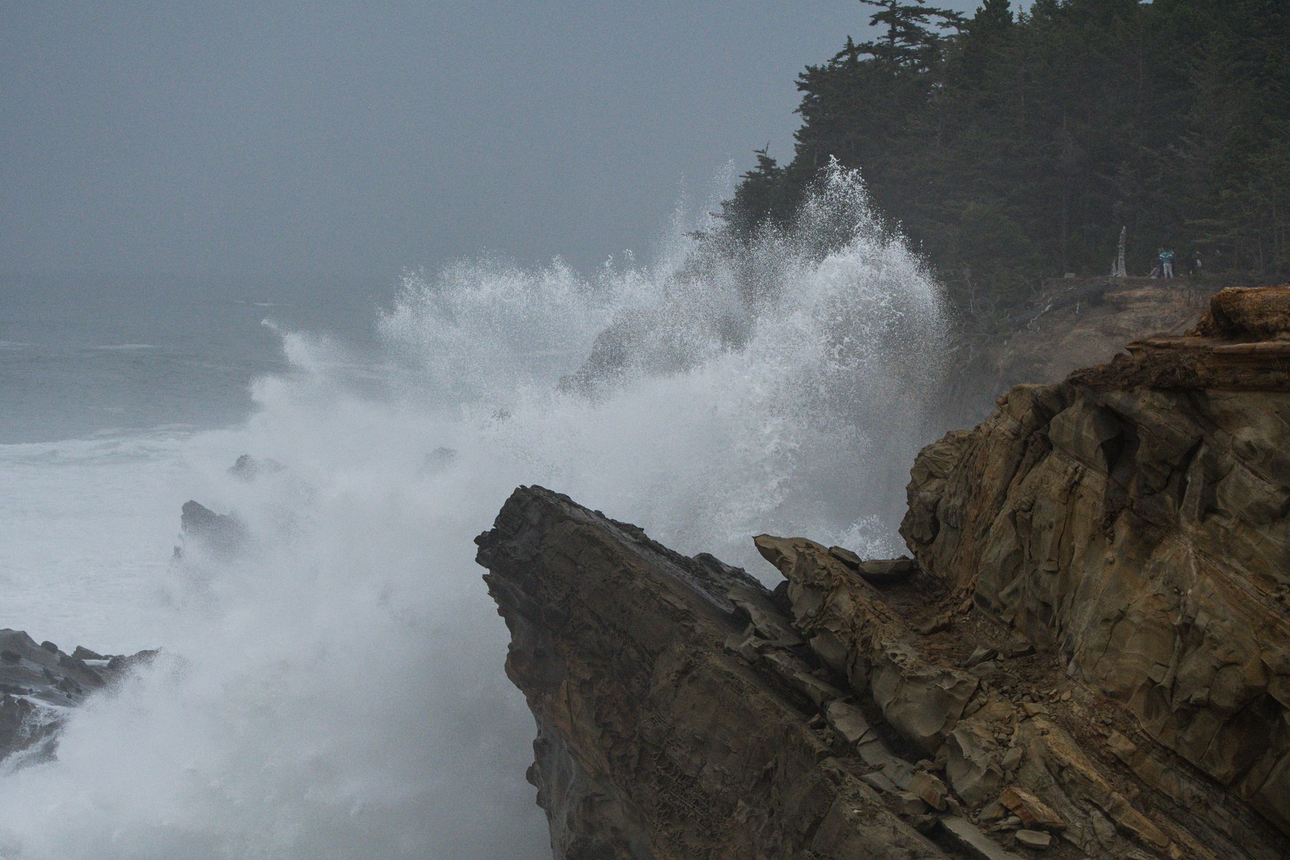
Thirty yards away, in the right conditions, the Pacific throws water seventy feet into the air and over the observation building.
Shore Acres State Park is the strangest of Oregon's coastal parks and one of the best, and both facts have the same explanation: a timber and shipping magnate built his estate in the wrong place, spectacularly.
Louis Simpson's house
Louis J. Simpson was the son of a lumber baron, and in 1906 he bought this headland as a gift for his wife. He built a substantial house, then a much larger one, with a heated indoor swimming pool and a ballroom, on a cliff exposed to the open Pacific. Around it he built formal gardens: a walled garden in the English style, a Japanese-influenced pond garden, and extensive plantings of specimens collected from his shipping company's voyages around the world.
The house burned in 1921. Simpson rebuilt. Then the Depression and a series of business failures ruined him, and in 1942 the state bought the estate. The second house was in poor condition and was demolished in 1948, and what survived was the garden.
So the park is the grounds of a house that no longer exists, maintained by a state parks department, on a cliff.
The garden now
It is still formally maintained, which is unusual for a state park anywhere. The walled garden holds the formal beds and the original layout, the Japanese-style pond garden sits below it, and the rose garden blooms through summer. Spring brings daffodils, rhododendrons and azaleas, which are the strongest display of the year, and winter brings the holiday lights, when the garden is decorated and opened in the evenings through December, drawing very large numbers and constituting a genuine regional tradition.
There is a small observation building on the site of the original house, glassed in, looking straight out to sea. It exists so you can watch the storms without being outside in them.
The storms, which are the point
This is the best storm-watching site on the Oregon coast, and the reason is the geometry. The cliff below the garden is sandstone, tilted and deeply eroded, forming a series of ledges, slots and channels, so when a large swell arrives it funnels into those channels and has nowhere to go but up. The result, in a big winter storm, is spray thrown seventy feet or more, repeatedly, directly in front of a viewing platform.
The conditions you want are a large Pacific swell, ideally 15 feet or more, arriving at high tide, and winter storms, particularly December through February, produce this regularly. Check a marine forecast rather than a land forecast, because swell height and period are what matter, not rainfall. And stay behind the railings and out of the fenced areas, because people have been killed on this coast by going out onto wet rock to get closer, and the whole design of the park is intended to let you avoid needing to.
Reading the sandstone
The cliffs at Shore Acres are worth looking at closely, because the rock is doing several unusual things at once. The formation is tilted sedimentary rock, sandstone and mudstone laid down in a marine basin and later uplifted and tipped, and because the beds are angled rather than horizontal the sea attacks them edge-on, cutting along the softer layers and leaving the harder ones standing. That produces the ribbed, fluted, layered surfaces that make these cliffs so photogenic, and the channels and slots that funnel the swell upward.
Concretions are the other feature, hard, roughly spherical masses that formed inside the sediment where minerals cemented around a nucleus, and as the softer surrounding rock erodes the concretions weather out, so the cliffs and beaches here hold them in sizes from a fist to a small car, some looking uncannily like cannonballs or eggs.
Honeycomb weathering, called tafoni, pits the sandstone into rounded cavities where salt crystallizes inside the pores and levers grains apart, producing a texture like a sponge on a sheltered face. All three processes are visible within a few hundred yards, which makes this one of the more instructive stretches of coast in Oregon.
The walking, and the other two parks
Shore Acres itself is small, and the hiking here is the Cape Arago trio: three state parks strung along a few miles of headland, connected by trail. Sunset Bay is the northern one, a nearly enclosed cove sheltered enough that the water is swimmable by Oregon standards, with a sand beach between sandstone bluffs, and it holds the campground for the group, including yurts. Shore Acres is the middle, with the garden and the cliffs. Cape Arago is the southern terminus, with three viewpoints, access down to coves, the closest views of the sea lion haul-outs, and the end of the road.
The Oregon Coast Trail links all three across about four miles of clifftop walking, and doing the full traverse one way with a car shuttle, or out and back for eight miles, is the best walking in the area. It is spectacular and much of it is close to the edge. Simpson Beach, below the garden, is reached on a short steep trail and is a sheltered cove that most garden visitors never find.
The three parks share a day-use permit, so one payment covers all of them, which is worth knowing because the fee rules on this coast are not consistent. Forty miles south, the Boardman corridor charges nothing at most of its pullouts, and a few miles north the dunes are federal ground on an entirely different system. Guidepole Hike carries the managing agency and what each site charges, which on a coast where three neighboring parks share one permit and the next one up the highway does not honor it is the layer that saves a wasted ticket.
The sea lions
Simpson Reef and Shell Island, offshore between Shore Acres and Cape Arago, hold the largest concentration of marine mammals on the Oregon coast. Steller sea lions, California sea lions, harbor seals and northern elephant seals all haul out there, in numbers that run into the thousands at peak.
You hear them before you see them, and from the Simpson Reef overlook the noise carries across the water constantly. Bring binoculars or a scope, because the overlook has interpretive panels and it is one of the best wildlife viewing points in the state park system. Whales pass on migration in winter and spring.
Shore Acres Storm WatchingCoos Bay, Charleston, and the timber that built it
The town at the head of the bay explains a lot about this coast. Coos Bay was for decades one of the largest timber shipping ports in the world, exporting logs and lumber from the Coast Range and the Klamath Mountains behind it, and the Simpson family fortune that built Shore Acres came from exactly that trade, along with shipbuilding.
The industry contracted sharply through the late twentieth century, for a mix of reasons including mechanization, log export policy, and the spotted owl litigation that reshaped federal forest management across the Northwest. What that means for a visitor is a town with a much larger industrial footprint than its current population suggests, and a landscape of second and third growth timber land that is still working forest rather than park.
Charleston, the fishing village at the bay mouth on the way to the parks, is worth stopping in. It is a working harbor with a commercial fleet landing Dungeness crab, pink shrimp, tuna and groundfish, and Dungeness crab is the significant one, since Oregon's commercial season typically opens in December and it is the state's most valuable single fishery, so buying crab off the boat here is one of the genuine pleasures of the southern coast. There are a handful of unpretentious places to eat and a fish market or two, and it is a considerably better lunch than anything inside the parks, which have none.
Two other things nearby are worth a day of their own. The Oregon Dunes National Recreation Area begins just north of Coos Bay and runs forty miles up the coast, a completely different landscape of open sand, and the South Slough National Estuarine Research Reserve, on the bay, was the first such reserve in the United States and has good trails through salt marsh and forest.
The gear
Storm watching is standing still outdoors in the worst weather of the year, on purpose, and the gear list says so.
A marine forecast, checked rather than the general one, which is the item that decides whether the trip is worth making. What produces the spectacular surf here is swell height and period together: a fifteen-foot swell at a long period does far more against these cliffs than a bigger swell at a short one. Winter storms with a high tide on top are the combination.
Genuine waterproofs, top and bottom, because you will be standing in wind-driven rain and salt spray for an hour or more.
Binoculars or a spotting scope, for the gray whales, which pass close inshore during the December and March migrations and which the observation building here is well set up for.
An Oregon day-use parking permit.
A lens cloth, and more than one, because salt spray on glass is the recurring frustration of this activity.
Sturdy shoes, for wet paved paths and slick headland ground.
And restraint, which is the actual safety item. The waves that make this place famous also come over the wall, the fences exist because people have been swept off these cliffs, and the good viewing is from behind them rather than beyond.
Tsunami awareness on this coast
Worth a short note, as on any Oregon headland. The Cascadia Subduction Zone offshore produces very large earthquakes at intervals of several hundred years, the last full rupture being in January 1700, and a local tsunami would arrive within fifteen to twenty minutes of the shaking, well before any official warning could reach you.
The rule is simple: a long rolling earthquake on the coast means move to high ground immediately, on foot. Shore Acres is comparatively well placed, since the garden and viewpoints sit on a headland, while Sunset Bay's beach and campground are the exposed part of this group and evacuation routes are signed there. It is one thing to know once rather than something to think about again.
Huge Wave Explosions at Shore Acres, Oregon CoastSeason and practical notes
Winter is the season, which is unusual for a coastal park, bringing storms, high surf, holiday lights and almost nobody in the garden. Spring is for the daffodils, rhododendrons and whale migration, summer is for roses, calm water and the cove beaches, and the largest crowds, and autumn is quiet and often clear.
A day-use parking permit is required, which in Oregon is $10 for the day in-state and $12 out-of-state, or $60 for a resident year. The garden is open year-round in daylight hours, and separately in December evenings for the lights, camping is at Sunset Bay and books six months ahead, and dogs are welcome on leash in the park and the garden. Coos Bay and Charleston are the nearest towns, about fifteen minutes away, and the road out from Charleston is narrow and winding and ends at Cape Arago. Cliff safety is the recurring theme, because the sandstone is undercut and friable, the fences are there for a reason, and rogue waves reach further up these rocks than anyone expects.
How to spend a day
In winter, arrive at high tide on a big swell, watch the storm from the observation building, then walk the garden, then drive down to Simpson Reef for the sea lions. In summer, walk the Oregon Coast Trail from Sunset Bay through Shore Acres to Cape Arago and back, four miles each way, with the garden in the middle and a swim at Sunset Bay after. And in any season the sea lions are always there and always loud.
It is worth a moment in the walled garden, with the hedges and the pond and a rose collection, to consider that a man built this on a cliff facing four thousand miles of open ocean, and that the ocean outlasted both his houses.
More Oregon coast in hiking the Oregon Coast, the Samuel Boardman corridor and Fort Stevens. The waterfall park is the Trail of Ten Falls, and Oregon's parking rules are in six states, six ways to charge you for a trailhead.
The rest of this coast is in Oregon coast hiking, the Samuel Boardman corridor and Fort Stevens State Park. The Washington equivalent at the river mouth is in Cape Disappointment. The parking permit is in state park passes by state, and the winter weather that produces the surf is worth reading alongside how to read a wildfire smoke map for the general habit of checking a forecast before driving.