Fish
Fish Fire
Fire Hike
Hike Bird
Bird

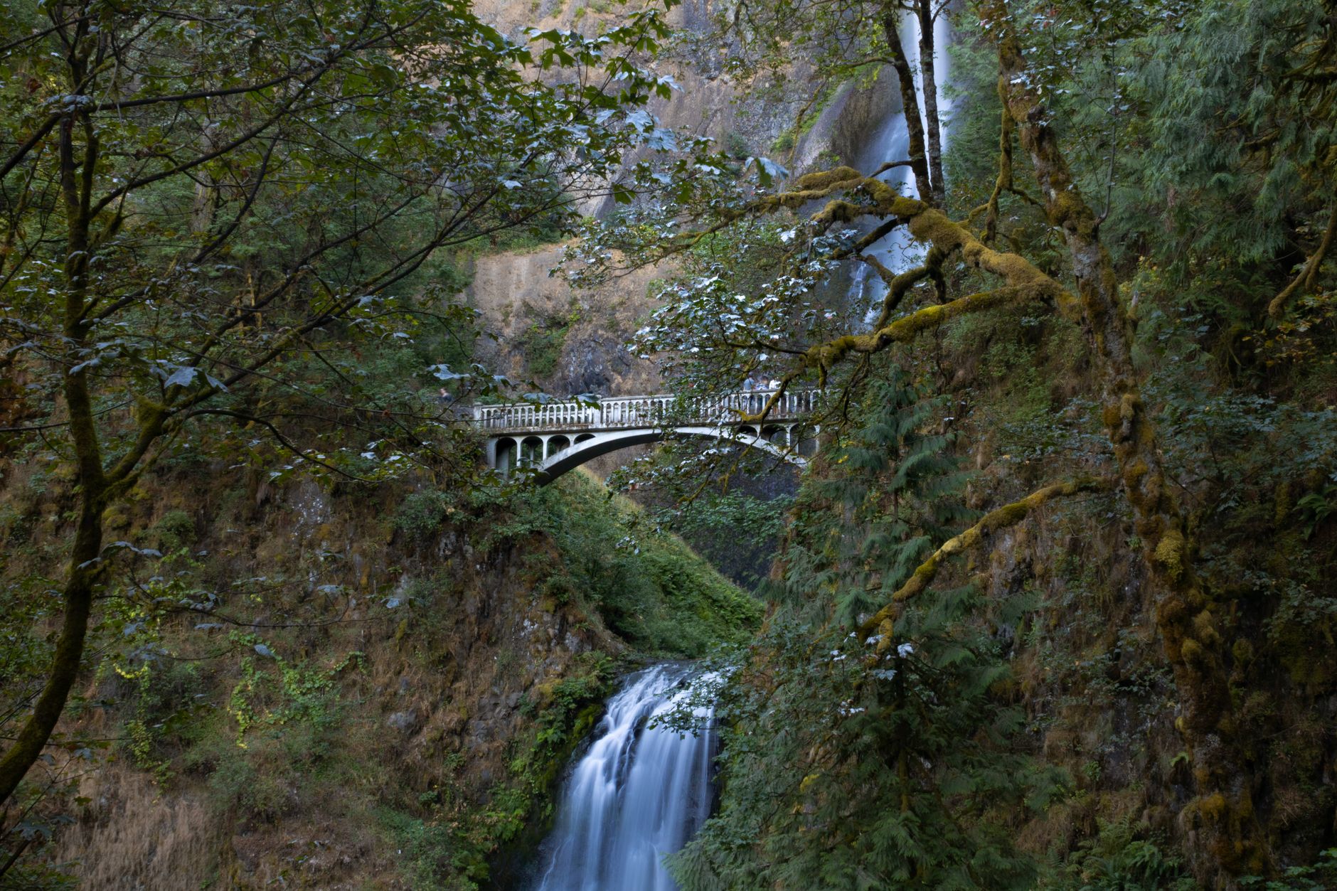

Multnomah Falls is the most visited natural attraction in Oregon, and the overwhelming majority of people who go there walk to the bridge, photograph it, and leave.
The loop above it is an excellent hike, and it is where the crowds evaporate almost immediately.
The Multnomah-Wahkeena Loop runs about 5.2 miles with roughly 1,610 feet of elevation gain, taking most people three to three and a half hours. It is rated hard despite the modest distance, because the climbing is sustained and the tread is steep in places. What you get for it is six waterfalls, a canyon that feels much wilder than its proximity to a freeway suggests, and a close look at a forest eight years into recovering from a fire that closed this entire area.
The permit nobody knows about
Start here, because it is the thing that most often goes wrong. A timed-use permit is required for the I-84 Exit 31 parking lot daily from 9am to 6pm, roughly late May through early September, which was May 22 to September 7 in 2026. People drive an hour from Portland, arrive at eleven on a Saturday in July, and discover they cannot park.
The permit is separate from any Northwest Forest Pass or Oregon State Park pass. It is specific to this corridor, and it exists because Multnomah Falls' popularity had become unmanageable.
The ways around it are to arrive before the window opens, arrive after it closes, come outside the season, or start the loop from the Wahkeena Falls trailhead instead, which is a short distance west along the Historic Columbia River Highway and has different, though also limited, parking. That last option is the useful one and it is also the least obvious, because it means one loop has two trailheads under two different permit regimes a mile apart. Guidepole Hike carries the requirement against each trailhead rather than against the trail, which is the level at which this particular problem lives.
Dates and rules change year to year. Confirm current requirements with the Columbia River Gorge National Scenic Area before you drive out.
The 2017 fire, and what it left
The Eagle Creek Fire started in September 2017, burned roughly 50,000 acres of the Oregon side of the Gorge, and closed this stretch of trail for years. Multnomah Falls itself was famously defended and the lodge survived. Walking the loop now, eight years on, the recovery is the most interesting thing about it.
The canopy is patchy, with standing dead trees remaining in numbers and the light on the forest floor far brighter than it was, which has produced dense green undergrowth of ferns, thimbleberry, fireweed, and young alder and maple coming up fast. Hazard trees are an ongoing issue, because burned trunks fall sometimes without warning and the agencies close sections for hazard-tree removal on a rolling basis, which is a genuine reason to check trail status rather than a formality.
Rockfall increased as well, since root systems that held slopes together burned and the winter after a fire is when the slopes let go, and some of the trail realignments date from that. And some trails have not reopened at all, so the Gorge's network is still not what it was in 2016 and old guidebooks and blog posts describe routes that no longer exist in that form.
It makes for a hike with a subject. You are not just walking past waterfalls, you are walking through a landscape in the middle of a process.
The Wahkeena and Multnomah Falls Loop: A Hike GuideThe loop itself
Most people walk it clockwise from Multnomah, though it works either way. Multnomah Falls at the bottom is the headline, a 620-foot two-tiered drop with the Benson Bridge crossing between the tiers, and this is where the crowds are. The paved switchbacks then climb from the bridge to the top of the falls, about a mile of steady zigzagging with a viewing platform at the lip, and most visitors turn around here, which is why the trail empties dramatically beyond it.
Above the falls the trail follows Multnomah Creek up a narrowing canyon past a string of smaller cascades, including Dutchman Falls, Wiesendanger Falls and Ecola Falls, through mossy basalt and dense green. This section is the reason to do the loop and it is lovely. The connector then crosses the plateau between the two drainages, through the burn, before dropping down Wahkeena Creek past Fairy Falls, a delicate fan over layered rock, and Wahkeena Falls itself, a 242-foot cascade near the road. The last stretch links back along the Historic Columbia River Highway or the connecting trail to your car.
Six named waterfalls in five miles is a rate very few hikes anywhere can match.
Doing it in the other direction
Most people start at Multnomah because that is where the parking and the famous view are, and starting at Wahkeena has real advantages. You climb the quieter side first, on trail rather than pavement, and arrive at the busy section on the descent when you are ready to be finished. The Wahkeena parking is separate and sometimes available when Multnomah is not, sitting outside the timed-permit lot. Fairy Falls comes early, which is a good thing to reach while you still have legs for photographs. And you finish at the lodge, which means food and toilets at the end rather than the start.
The argument for the standard direction is that the paved switchbacks are easier to climb than to descend on tired knees, which is fair. Both work, and the Wahkeena start is less obvious and correspondingly less crowded.
Why the Gorge has this many waterfalls
The density is not an accident, and the geology explains it. The Gorge is cut through the Columbia River Basalt Group, enormous lava flows that covered much of the Pacific Northwest between roughly 17 and 6 million years ago, stacking hundreds of individual flows on top of one another, and the visible layering in the cliffs is those flows.
Then the Missoula Floods at the end of the last ice age scoured the Gorge repeatedly, cutting it deeper and faster than the tributary streams could keep up with, which left a main valley far lower than the side valleys feeding it. Those side streams now arrive at the edge of a cliff and fall, which is what a hanging valley is, and the Oregon side of the Gorge has one of the highest concentrations of waterfalls in North America because of it.
The basalt matters for the hiking too. It fractures into columns, it holds moss and fern in the wet, and it polishes to something slick underfoot, which is why grip is the property that matters most on these trails.
The lodge, the bridge, and the history
This is one of the more heavily built pieces of American landscape, and the structures are part of what you are visiting. Benson Bridge, the arched footbridge between the two tiers, was built in 1914 and is named for Simon Benson, the timber magnate who bought the falls and surrounding land and donated them for public use.
Multnomah Falls Lodge dates to 1925, built of local stone in the rustic style, and it remains in operation with food, toilets and an information desk, which makes it a genuine historic building rather than a gift shop with a view. The Historic Columbia River Highway itself, completed in the late 1910s, was the first planned scenic roadway in the United States, deliberately routed to showcase the waterfalls, and the stonework, the arched viaducts and the tight radius curves are all original design intent.
Which means the crowds here are not new. People have been coming to this exact spot in numbers for over a century, and the infrastructure was built to receive them.
Two Dollar Permits Required to Park at Multnomah FallsConditions and season
Spring is the best time, because the falls run hardest with snowmelt and rain, the new growth is vivid, and the burn areas green up fast. Summer is the busiest and the driest, when the timed permit applies and the falls are at their weakest. Autumn brings color to the young hardwoods that have come in since the fire, and thinner crowds.
Winter is worth doing. The falls are powerful, the crowds are gone, and on a cold snap Multnomah occasionally partially freezes, which is spectacular. But the upper trail ices badly, the basalt is slick, microspikes are close to essential, and sections close for ice. Rain, meanwhile, is normal and the hike is good in it, because this is a temperate rainforest and the whole thing looks better wet.
The gear
A five-mile loop past a dozen waterfalls, forty minutes from Portland, on trails that are wet almost every day of the year.
Shoes with sticky rubber, which matters here more than tread depth. The trail surface is basalt, it is wet from spray and rain most of the year, and the mossy sections above Wahkeena are genuinely slippery.
Kahtoola MICROspikes, from December through February, when the Gorge produces its famous ice storms and the paved switchbacks above Multnomah Falls turn into a sheet.
A rain shell, in a corridor that funnels Pacific weather inland and gets over seventy inches a year.
A timed-use permit for the season and hour, which is the item that stops people at the gate. Multnomah Falls has required a timed-entry permit for the parking area and viewing platform in peak season since 2022, it is booked on Recreation.gov, and it is separate from the Northwest Forest Pass the trailheads want.
Trekking poles, for the descent, which is a long paved and then unpaved grade.
Water carried from the lodge, since there is none on the loop and the creek water is not to be trusted.
And a headlamp, because the Gorge is a north-facing canyon and it goes dark under the canopy well before it does outside.
What it asks of you
Steady climbing, first of all, because sixteen hundred feet over a couple of miles is a real ascent and the paved section is deceptively tiring. Careful footing throughout, since wet basalt, moss and worn stone are slippery and the exposure beside the creek in places is real. Attention to closures, because hazard trees and rockfall shut sections at short notice and the network changed permanently after 2017. And tolerance for crowds at the bottom, since the first mile is busy at almost any hour in season and that is the price of the trailhead.
Practically: the I-84 exit and the Historic Highway are two different approaches and which one you use determines the permit situation. Dogs are allowed on leash. Parking outside designated areas is cited and towed, and carpooling is recommended. Signal is patchy in the canyon. And there is no potable water on the loop, though there is at the lodge.
If it is too busy
The Gorge has a lot more than this. Angel's Rest, at 4.8 miles and 1,500 feet, gives an exposed viewpoint over the river rather than waterfalls. Latourell Falls further west is a shorter loop around a striking columnar-basalt fall with far fewer people. Horsetail and Ponytail Falls just east include a trail that passes behind a waterfall. And Dog Mountain is the hard option, with a wildflower display in May and June that requires its own permit.
The Washington side of the Gorge is also consistently quieter than the Oregon side, which is the broader answer on a busy weekend.
Walk past the top of the falls
Check whether you need a timed permit for the date and time you are arriving, because that is the single most common way this hike goes wrong. Go early or out of season. Walk past the top of the falls, which is where 90 percent of people stop and where the good part starts.
Carry traction in winter, expect wet rock in every season, and check for closures because this forest is still dropping trees.
Then look at the standing snags and the fireweed and the young alder coming up through it, and take the loop for what it now is: a waterfall hike through a recovering burn, which is a more interesting thing than it was before 2017.
The wider picture of using the Gorge alongside the city's own forest is in hiking Portland. Oregon's marquee volcano loop is the Timberline Trail, and its most accessible big summit is South Sister.
The city forty minutes west is in hiking Portland. The volcano an hour east is in the Timberline Trail on Mount Hood, and the drier half of the state is in Bend Oregon day hikes. The coast is in Oregon coast hiking, and the fire history that shaped this specific corridor is worth reading alongside red flag warnings explained.
One further note on the falls themselves, since the number gets quoted wrong constantly. Multnomah Falls is frequently called the second tallest year-round waterfall in the country, which is a claim the Forest Service itself has walked back. Height rankings depend on how you count tiers and how you define year-round, and by most consistent measures it is not in the top ten. It is still six hundred and twenty feet of water falling off a basalt cliff forty minutes from a major city, which is remarkable enough without the ranking.