Fish
Fish Fire
Fire Hike
Hike Bird
Bird

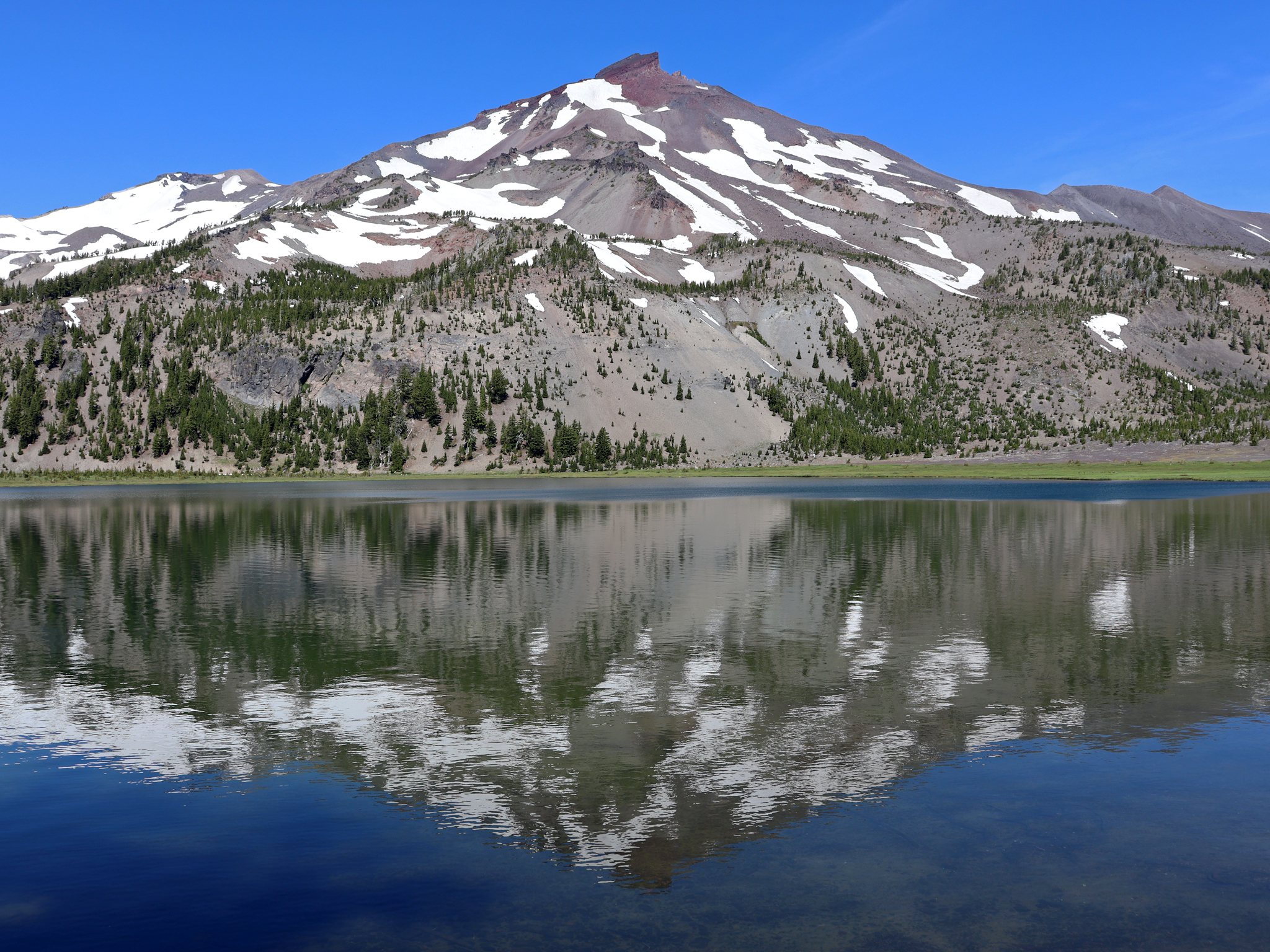

South Sister is the most approachable 10,000-foot summit in Oregon, and that reputation does it no favors.
There is a trail to the top. There is no rope, no rock, no glacier travel on the standard route, and no scrambling that deserves the name. On paper it is a hike. In practice it is 12.6 miles and roughly 4,900 feet of climbing that finishes on loose volcanic cinder above 9,000 feet, and the people who struggle on it are almost always the people who read the words "walk-up" and stopped reading there.
Done with clear eyes it is one of the best days in the Oregon Cascades.
The permit, which is easy to get and easy to forget
A Central Cascades Wilderness Permit is required from June 15 through October 15 for the Three Sisters Wilderness, including the South Sister Climber Trail. Day-use permits for this trailhead are limited and reservable through Recreation.gov, and this is the detail that turns people around at the kiosk: it is not the Enchantments, but you cannot just show up in August and start walking.
Outside that window no wilderness permit is required, though a Northwest Forest Pass or equivalent may still be needed to park. Requirements shift, so confirm both the permit and the parking pass with the Deschutes National Forest before you drive out.
The trap worth naming is that the permit season and the hikeable season are two different things. Permits open on June 15, while the upper cinder slopes frequently do not melt out until late July, so a June permit can buy you the right to attempt a route that still wants an ice axe. Guidepole Hike carries the permit window and current route conditions against the same trailhead, which is what keeps those two calendars from being confused for each other, because booking the earliest available date is exactly the wrong instinct on this mountain.
South Sister Summit Climb: Oregon's Third Highest PeakThe route, in three completely different acts
What makes South Sister interesting is that it is three hikes stacked on top of each other, and each one demands something different. The standard route climbs the south ridge from the Devils Lake Trailhead at 5,446 feet, 26 miles west of Bend on the Cascade Lakes Highway.
Act one is the forest. From Devils Lake the South Sister Climber Trail crosses Tyee Creek and the highway and starts climbing immediately through hemlock and fir, steep, relentless and utterly viewless for about a mile and a half. It is also the coolest and shadiest part of your day, which matters more than it sounds.
Act two is the plateau. The forest ends abruptly and the landscape changes completely into a broad, flat, treeless plain of volcanic sand with the mountain standing directly in front of you. This is the psychological trap of South Sister, because the walking is easy, the views are enormous, the summit looks close, and it is not close at all. Moraine Lake sits off to the side and makes a fine turnaround for anyone who has already had a good day.
Act three is the cinder cone, and it is the real climb: a long, steep grind up loose red cinder and scree where footing is poor, every step gives back a fraction of itself, and there is no shade and no water. This is where South Sister earns its elevation, and where the false summit lives, because you crest what is obviously the top and find the crater rim with the true summit a further walk around it.
Round the rim, look into Teardrop Pool, and on a clear day you get the entire Cascade volcanic chain: Broken Top and Mount Bachelor close in, Middle and North Sister next door, and Jefferson, Hood, Adams and sometimes Rainier stacked away to the north.
The descent is its own event
Going down South Sister is faster than going up and considerably harder on your body than the mileage implies. The cinder that fought you on the ascent now works differently, because every step slides, which is quick and quite fun for the first few hundred feet and then becomes a sustained braking exercise on quadriceps that have already done 4,900 feet of climbing.
Poles are not optional equipment on this descent for most people, and neither are gaiters unless you enjoy stopping every ten minutes to pour grit out of your shoes. Then comes the plateau, which feels endless in the other direction, and finally the forest switchbacks, which are steep enough to be unpleasant on tired knees. Budget real time for the way down rather than assuming it is the easy half.
Timing it
Snow governs everything. The upper cinder slopes hold snow well into summer and in a heavy year an ice axe and the ability to use it are required into July, so most hikers wait for the route to melt out and late July through September is the reliable window.
Start early, both for the parking, which fills on summer weekends, and for the weather, because afternoon thunderstorms build over the Cascades and the entire upper half of this route is exposed above treeline with nowhere to shelter. Budget 8 to 12 hours, with fit parties going faster, and remember that the descent on loose cinder is quicker than the ascent but harder on knees and ankles than the mileage suggests.
Altitude is the quieter factor. Ten thousand feet is high enough to slow people down noticeably, particularly anyone arriving from sea level and hiking the next morning, and sleeping a night in Bend at 3,600 feet first helps more than it seems like it should.
South Sister Summit Hike: Permit, Tips and Trail GuideWhat goes wrong
The common failures on South Sister are boringly consistent, which is good news because they are avoidable.
Underestimating water is the first, since there is none above the plateau, so three liters is a sensible minimum on a warm day and people routinely carry two. Wrong footwear is the second, because trail runners with worn tread are miserable on cinder and you want tread that bites plus, ideally, gaiters, since you will otherwise empty volcanic grit out of your shoes repeatedly.
No sun protection is the third, because above the treeline there is no shade for hours, at altitude, often over snow, and sunburn on this mountain is close to universal among people who did not plan for it. And the fourth is treating the plateau as the hard part being over, when it is the middle rather than the end.
The gear
South Sister is a walk-up volcano with no technical climbing on it and a summit day that defeats a lot of fit people, mostly through the surface underfoot.
Low gaiters, which are not optional here. The upper mountain is loose red cinder and pumice that pours into shoes continuously, and without gaiters you will stop three times to empty them.
Hiking shoes with aggressive tread, for the same ground.
A three-liter reservoir, because there is water at Moraine Lake near the bottom and nothing above it, and the summit push is exposed for two thousand feet.
A sun hoody and high-SPF sunscreen, since you are above the treeline for most of the day at over nine thousand feet on reflective volcanic rock and snow.
Trekking poles, which do more work on this mountain than on most. The descent through the cinder is a controlled slide and poles are what keep it controlled.
An ice axe and the training to use it, if you are going before mid-July, when the summit slopes hold firm snow above a long runout. Without both, wait.
And a Central Cascades Wilderness Permit, booked on Recreation.gov, which is the thing that most often stops people at the trailhead. It is separate from the Northwest Forest Pass, the popular days sell out, and it is checked.
Basing yourself in Bend
Bend is the reason South Sister gets climbed as casually as it does. The town sits at about 3,600 feet, 26 miles from the trailhead, with the Cascade Lakes Highway running west past a string of lakes and trailheads before it reaches Devils Lake.
That proximity is worth using deliberately, because arriving the day before and sleeping at Bend's elevation makes a measurable difference to how the last 2,000 feet feel, particularly for anyone coming from sea level. There is also a campground at Devils Lake itself, right at the trailhead, which solves both the acclimatization and the dawn-start parking problem in one move.
The highway is closed by snow in winter and typically opens in late spring, which is the practical gate on the season regardless of what the trail is doing.
The volcano you are standing on
It is worth knowing what South Sister is, because it shapes everything underfoot. It is a stratovolcano and the tallest of the Three Sisters at 10,363 feet, which makes it the third-highest peak in Oregon, and it is the youngest of the three, which is to say that geologically it is not finished.
That youth explains the walking. The loose red and black cinder that makes the upper climb so tedious is young volcanic rock that has not had time to consolidate into anything you would call soil. The reason there is no water above the plateau is that porous volcanic ground does not hold surface water. And the reason the plateau is a flat treeless plain of sand is that it is volcanic deposit rather than a meadow that failed to grow trees.
The summit crater holds Teardrop Pool, the highest lake in Oregon at roughly 150 feet by 50 feet at close to 10,200 feet, ice-fed and frozen for much of the year. Circling the rim to reach the true high point takes you around a genuine volcanic crater, which is a strange and worthwhile thing to do on foot without a rope in your hand.
North and Middle Sister sit immediately next door and are a different proposition entirely, because both involve real climbing. South Sister is the one the trail goes up, which is exactly why it deserves more respect than its reputation gives it.
Leaving it as you found it
The Three Sisters Wilderness takes heavy traffic and the alpine ground above the treeline recovers from damage on a timescale of decades rather than seasons.
Two things matter more than everything else. Stay on the established route across the plateau and the cinder, because the temptation to cut a switchback or fan out across open ground is strong when the walking is easy and the route is obvious, and braided social trails across volcanic soil are exactly how these landscapes get scarred. And pack out everything including food scraps, which the local ground squirrels and jays have already learned to expect from people.
There is no water above the plateau, which also means there is nowhere to wash and no discreet way to deal with waste high on the mountain, so plan for that below the treeline rather than improvising at 9,000 feet, and check the Deschutes National Forest's current human-waste guidance for the wilderness, which is stricter in some areas than general practice.
The permit system exists because this place was being loved to pieces. Hiking it well is part of the price of it staying open.
If the summit is not the day
There is no shame in a shorter version, and the shorter versions are good. Moraine Lake off the plateau is a fine destination with most of the views and a fraction of the suffering, and the plateau itself is a superb turnaround, giving you the full alpine landscape and the mountain in your face without the cinder grind. Both need the same permit and neither requires you to have anything left in the tank.
And if the trailhead is full or the permit is gone, the Cascade Lakes Highway is lined with alternatives within a few minutes' drive. Green Lakes, tucked between South Sister and Broken Top, is one of the finest basins in the Cascades and a much gentler day, while Broken Top and the Tam McArthur Rim deliver high alpine views for far less climbing. All sit under the same Central Cascades permit system, so check which specific trailheads are limited when you book.
More respect than its reputation gives it
Reserve the permit early, wait for the melt-out, start at dawn, carry more water than feels reasonable, and know before you leave the plateau that the summit is still a long way up.
South Sister does not ask for skills you do not have. It asks for a full day's fitness, honest preparation, and the sense to turn around on the cinder if the day is not going your way. Give it those things and it hands back one of the great views in the Pacific Northwest.
The other Cascade peak hikers train on before this one is Mount Si up in Washington, a third of the distance, the same unbroken uphill. The wider menu around town is in day hiking Bend.
And if you are basing in Bend anyway, the Cascade Lakes Highway you drove out on is lined with water as well as trailheads. How to fish Bend covers the lakes you passed, which is a good use of the day after, when your legs have opinions about the cinder.
The town at the base and the rest of its trails are in Bend Oregon day hikes. The other Oregon volcano with a route around rather than up it is in the Timberline Trail on Mount Hood. The state's other signature walks are in the Multnomah and Wahkeena loop and Oregon coast hiking, and the smoke that can close the season is covered in how to read a wildfire smoke map.