Fish
Fish Fire
Fire Hike
Hike Bird
Bird

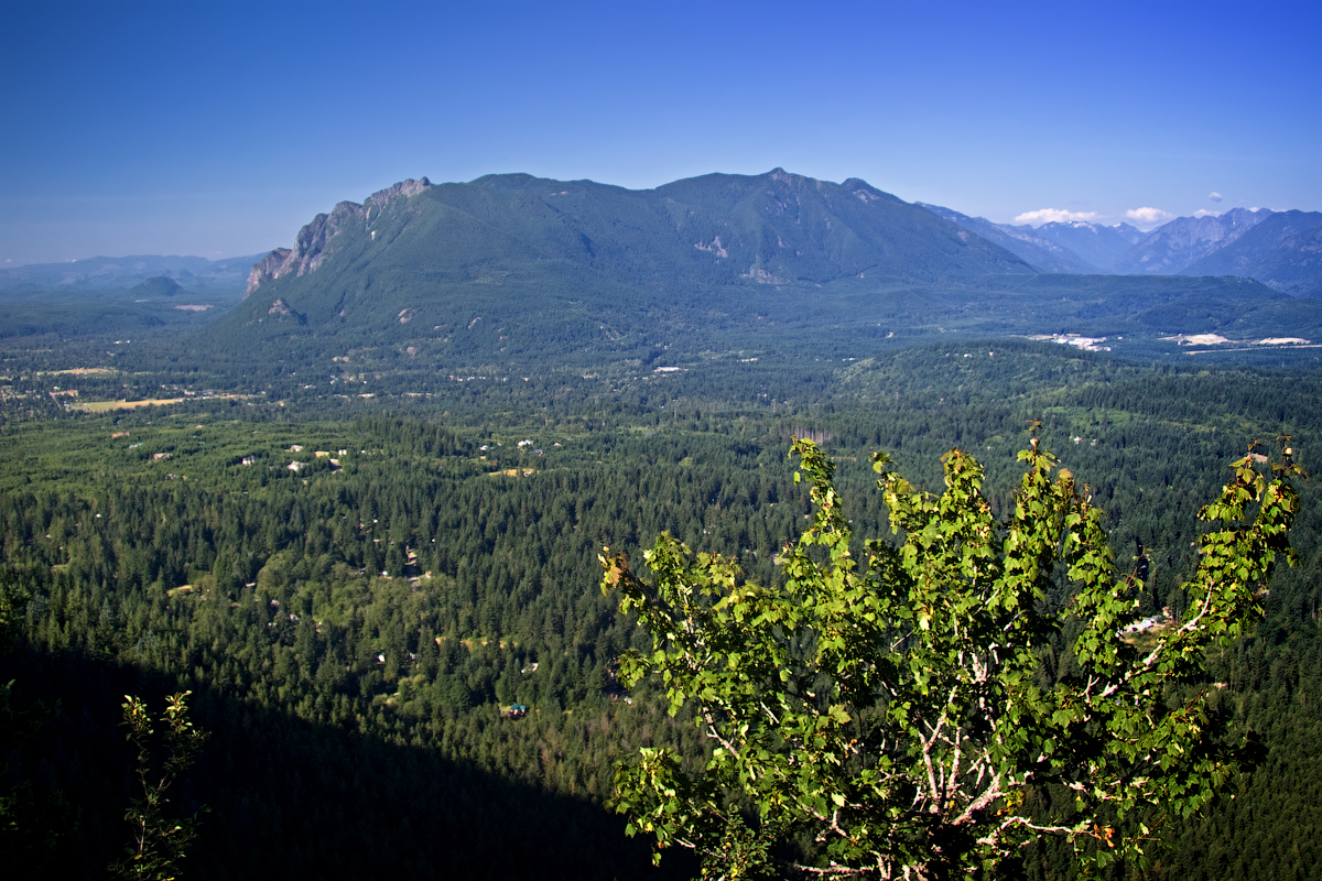

The Mount Si parking lot at seven in the morning on a Saturday in July is a strange scene. Half the cars are still running. People are lacing boots on tailgates, and a surprising number of them are loading rocks, water jugs, or sandbags into backpacks. Mount Si is where Seattle trains. It is where people getting ready for Rainier, for Kilimanjaro, for the Enchantments, go to find out whether their legs work.
That reputation is the problem. Treated purely as a stair machine with a view at the top, Mount Si is a grim eight miles: 3,150 feet of relentless switchbacks through second-growth forest, a crowded rock ledge, and the same eight miles back down on knees that have stopped forgiving you. Plenty of people do it once, check it off, and never come back.
That is a waste, because the mountain is more interesting than its reputation. It is the remnant of an oceanic plate volcano, a mass of highly metamorphosed Jurassic and Cretaceous rock that got scraped onto the edge of the continent. Its west face is the one in the opening credits of Twin Peaks. The Snoqualmie people, whose valley it stands over, call it q̓əlbc̓, and it holds a place in their creation story. There is a 350-year-old Douglas fir standing two miles up that survived a fire which smoldered for weeks. And there is a rock at the top that has put more than one hiker in a helicopter this year.
Here is how to hike it well.
The numbers, and what they mean
The Mount Si trail is 8.0 miles round trip with 3,150 feet of elevation gain, topping out at a 3,900-foot shoulder below the true summit. Those are Washington Trails Association's figures and they are the ones to plan against.
The gain is what matters, not the mileage. Eight miles is a pleasant afternoon on flat ground, while eight miles with 3,150 feet in it means climbing an average grade of roughly 15 percent the entire way up, with no meaningful flat sections to recover on. If you have not done a hike with 3,000 feet of gain before, budget four to six hours car to car and do not be embarrassed about it. Fit hikers do it in three and trail runners in well under two, and none of that has any bearing on how your day should go.
The summit itself is 4,167 feet. The trail does not take you there. That 267-foot gap between where the trail ends and where the mountain peaks is the single most important thing to understand about Mount Si, and we will come back to it.
The climb, mile by mile
The trailhead sits at the end of SE Mount Si Road, about two and a half miles off North Bend Way, reached from Seattle by I-90 to Exit 32, then left onto 436th Ave SE and a short dogleg through town. The lot is large, and on a clear weekend it is still not large enough.
The first mile and a half is the honest part of the deal: switchbacks under second-growth Douglas fir and hemlock, well-graded, wide and heavily maintained. There is no view, and nothing to look at except the forest, which is lovely if you stop treating the climb as an obstacle between you and the top. This is a National Recreation Trail and it shows in the tread work.
Snag Flats, at roughly 1.7 miles, is the one place on the way up where the grade relents, and you should take the interpretive boardwalk. It was built by trail volunteers in 1994 and it exists to point out something specific: a stand of old growth that survived the 1910 fire, including a Douglas fir around 350 years old. That fire smoldered in this basin for weeks, and standing next to a tree that was already 240 years old when it happened, in a forest that otherwise burned, is worth the four minutes it costs you. Most people walk straight past it. Do not be most people.
After milepost two the trail gets down to business with a second, longer set of switchbacks, and this is the stretch that earns Mount Si its reputation. Head down, steady pace, no heroics.
At about 3.75 miles the forest opens onto a talus slope and the whole point of the hike arrives at once: the Snoqualmie Valley spread out 3,000 feet below, North Bend looking like a model railway, the Cascades stacked up to the east, and on a clear day Rainier hanging over the southern horizon. This is where the trail ends and where the vast majority of hikers should stop, because the rock is broad, there is room to sit, and the view from here is not meaningfully worse than the view from the true summit.
Hike Mount Si, North Bend, Washington: trail conditions and summit viewsThe gray jays will find you within about ninety seconds of opening food, and so will the chipmunks. Do not feed them, because they are habituated to the point of landing on hands, and every person who tops that up is making the problem worse for the animals rather than befriending them.
The Haystack, and why it keeps making the news
The rocky block above the talus is the Haystack, and it is Mount Si's true summit. Getting up it is a Class 3 scramble: roughly 150 feet of near-vertical rock with real exposure, no fixed protection, and a fall line that goes a long way.
It has been a bad year on it. In May 2026, crews from Eastside Fire and Rescue, Bellevue Fire, and King County Search and Rescue hoisted a critically injured hiker off the Haystack after a fall of roughly fifty feet, working in hail and snow at 4,100 feet. Ten days later, over Memorial Day weekend, a group of teenagers got stranded on the same feature and had to be located by drone and brought down by rescue volunteers. The Snoqualmie Valley Record recorded one rescue and one death on the mountain in that month alone.
The pattern in these incidents is consistent and it is not about fitness. People arrive at the talus slope after a hard climb, see a rock, and go up it without registering that the trail has ended and a scramble has begun. Going up Class 3 terrain is almost always easier than coming down it, which is where people get stuck, and add wet rock and the friction that made the moves feel reasonable on the way up is not there anymore.
So, plainly. If the rock is wet, icy or snowed on, the Haystack is a no rather than a maybe. If you have not scrambled Class 3 before, do not learn it 3,900 feet up with a crowd behind you. If you are not confident you can reverse every move you make, do not make the move. And understand that the view from the talus is the view, so you are not missing the payoff.
None of this is a reason to avoid Mount Si. It is a reason to know exactly where your hike ends before you start walking.
Trail Guide for Hiking Mount Si and Scrambling Up the True SummitSolving the parking problem by not parking
Mount Si takes somewhere between 80,000 and 100,000 hikers a year and the lot fills early. On a clear summer Saturday, arriving after eight means circling, and cars parked along the road get ticketed, because the lot is regularly patrolled.
The fix that almost nobody uses is Trailhead Direct. King County Metro runs a seasonal shuttle straight to the Mount Si trailhead, roughly every 30 minutes, on weekends and select weekday holidays. In 2026 it ran from Memorial Day weekend through August 30, picking up near the Kaiser Permanente Capitol Hill campus, the Capitol Hill and Symphony light rail stations, and South Bellevue station, running through downtown Seattle and North Bend to the trailhead. Adult fare was three dollars one way, riders 18 and under rode free, and income-restricted adults, seniors, Medicare recipients and disabled adults paid a dollar.
Three dollars and no parking anxiety, from a light rail station, to one of the best viewpoints in the Puget Sound basin. Check trailheaddirect.org for the current season's dates and the last return trip, which is the detail people get caught out by.
If you are driving, be in the lot before 7:30 on a summer weekend, or go on a weekday, or go in the rain. Mount Si in light rain, with the valley steaming below you and nobody else on the switchbacks, is a better hike than Mount Si in August sunshine.
Seasons, snow, and the shoulder-season trap
Mount Si is hiked year-round, which is not the same as saying it is the same hike year-round.
Summer, July to September, is dry, hot on the lower switchbacks and crowded, so start early for the parking and the temperature both, and carry more water than the mileage suggests, because the climb is continuous and there is no water on the trail. Autumn, October to November, is the best time to be on it, when the crowds thin, the forest is wet and green, and the valley fog below the viewpoint on a clear morning is the reason to have come.
In winter, December to March, the lower trail is usually clear and muddy and the upper mountain is not, because snow and ice accumulate on the last mile and on the talus slope, which is exactly where the exposure is. Microspikes belong in the pack from November through April, and a 2026 winter rescue on the mountain involved a helicopter hoist in conditions that had looked fine from the parking lot. Daylight is the other constraint, since leaving the trailhead at noon in December means finishing in the dark, so carry a headlamp.
Spring, April to June, is the trap. The trailhead is in full green-up while the summit block can still be holding snow and running with meltwater, and this is the window that produced the May 2026 incidents. Check recent trip reports rather than the forecast in town.
The gear
Mount Si is thirty minutes from Seattle and it kills the illusion that proximity means easy. The gear list is a real mountain list, scaled down.
Kahtoola MICROspikes, which are the item that matters most and the one people skip because the trailhead is at nine hundred feet. The summit is at four thousand and it holds ice from November through April in most years, on a trail that is a steady grade with drop-offs on the upper switchbacks. The parking lot being bare tells you nothing about the top.
Hiking shoes with real grip rather than trail runners, since the tread here is roots and wet rock most of the year.
Trekking poles, for a descent that gives back thirty-two hundred feet in four miles and is the reason most Mount Si sufferers suffer the next day.
A daypack in the twenty-liter range, which is the right size for water, layers and food and no larger.
Two liters of water, since there is none on the trail.
A headlamp, always, because this is the most popular training hike in the state and a great many people start it too late in the afternoon.
And an annual Washington State Discover Pass, since the trailhead is Department of Natural Resources land and the lot is patrolled. It also covers the state parks you will end up using.
Rules, passes, and closures
Mount Si sits in the Mount Si Natural Resources Conservation Area, managed by Washington's Department of Natural Resources rather than the Forest Service or the Park Service, and that distinction determines everything about the rules.
A Washington State Discover Pass is required to park at the Mount Si trailhead and at the Little Si trailhead, with an annual pass the cheapest option if you hike in Washington more than a few times a year, day passes available, and the lot patrolled. It is day use only, with no overnight camping in the NRCA. Dogs are allowed on leash.
And closures happen. DNR closed Mount Si, Little Si and Mount Teneriffe and reopened them on June 18, 2026, with a standing advisory to be aware of your surroundings and to review bear safety guidance. That closure was not announced far in advance, which is the whole problem with checking a cached trail listing and driving out. Guidepole Hike carries current closures against the trail itself, and DNR's own alerts page for the NRCA remains the final authority.
Rules and pass requirements do change, so confirm current conditions and closures with Washington DNR before you drive out.
When Mount Si is full: the two obvious alternatives
Both are in the same NRCA, both take the same Discover Pass, and both are five minutes from the Mount Si lot.
Little Si is 3.7 miles round trip with 1,300 feet of gain to a 1,550-foot rocky bluff, and it is not a consolation prize. It is a good moderate hike through mossy forest and past the basalt walls that make this one of the region's climbing areas, and it is the right call with kids, with a dog that is new to trails, or on a short winter afternoon.
Mount Teneriffe is the opposite answer at 13 miles round trip, 3,800 feet of gain and a 4,788-foot summit. It is longer and higher than Mount Si and less crowded, because most people do not want either of those things, so if you came for the workout rather than the view this is the better mountain and you will have more of it to yourself.
Stop treating it as a benchmark
The way to enjoy Mount Si is to stop treating it as a benchmark. Go on a weekday or in weather. Take the shuttle if it is running. Stop at Snag Flats and read the signs. Climb the switchbacks at a pace you could hold a conversation at. Sit on the talus for half an hour instead of ten minutes. Leave the Haystack alone unless you scramble, and leave it alone regardless if the rock is wet.
Do that and it stops being Seattle's Stairmaster and starts being what it is: an unreasonably good mountain to have 45 minutes from a major city.
If Mount Si was your training hike rather than your destination, the thing most people are training for is two hours east: the Enchantments, where the hard part is winning the permit before you ever touch the trail. The steeper local alternative is Mailbox Peak, 4,000 feet in 2.5 miles on the old trail.
And the Snoqualmie River you crossed on the way in is worth its own day. North Bend is the access point for that too, so if you want the valley from the water instead of from 3,000 feet above it, fly fishing the Snoqualmie covers the same ground at river level.
The harder training hike ten minutes further east is in Mailbox Peak. The city these trails serve is in hiking Seattle, and the things people train for on this hill are in one day at Mount Rainier and the Enchantments permit lottery. The agency question, which decides which pass the lot wants, is in dog-friendly trail rules by agency.