Fish
Fish Fire
Fire Hike
Hike Bird
Bird


Two things at Fort Stevens are unusual, and both are accidents of geography.
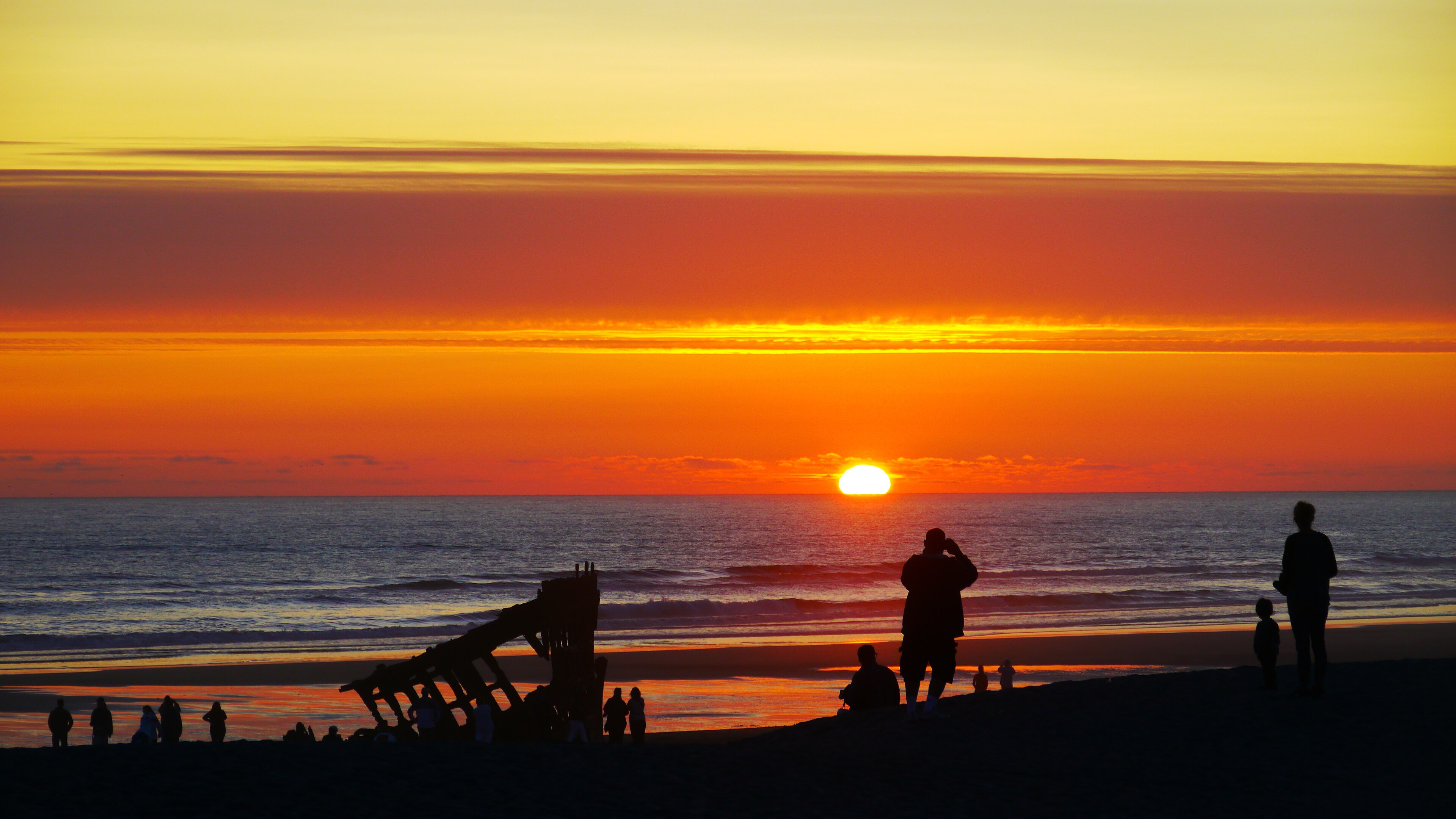
The first is the Peter Iredale, a four-masted steel barque that ran aground on the beach here in 1906. Its rusted bow is still there, half-buried in the sand, one of the most accessible shipwrecks anywhere on the American coast.
The second is that on the night of June 21, 1942, a Japanese submarine surfaced offshore and shelled the fort. It caused almost no damage. It also made Fort Stevens the only military installation in the continental United States to be fired upon by a foreign power since the War of 1812.
Around those two facts sits a 4,300-acre state park with about nine miles of trail at the very northwestern corner of Oregon.
The fort
Construction began during the Civil War, in 1863, to defend the mouth of the Columbia against a possible Confederate or British attack that never came. It was rebuilt and re-armed repeatedly, with Endicott-era concrete batteries at the turn of the century, upgrades through both world wars, and continuous service until 1947.
With Fort Canby and Fort Columbia on the Washington side it formed the Harbor Defenses of the Columbia, a three-fort system covering the river mouth in crossfire. What survives here is a substantial complex of concrete gun emplacements, magazines, observation stations and command posts scattered through the coastal forest and dunes, and Battery Russell is the most impressive and the one the Japanese submarine targeted.
You can walk into most of them. They are dark, damp, echoing and covered in moss, and they are among the more atmospheric things on the Oregon coast.
That three-fort system is also a small lesson in how American public land works, because the other two are four miles away across the bridge and in a different state, which means a different park system, a different pass and different rules for what looks like one continuous defensive work. Guidepole Hike carries the managing agency and its requirements against each site, which around a river mouth split between two states saves buying the wrong pass for the second fort of the day.
The Peter Iredale
The ship was bound for Portland from Mexico in October 1906 when a squall and a strong current put her onto Clatsop Spit. The crew was rescued and nobody died, salvage was attempted and abandoned, and she has been there ever since.
What remains is the bow section and some ribs, rusted to a deep orange, standing in the surf zone. At low tide you can walk right up to and around it, and at high tide it is partly in the water. It is one of the most photographed objects on the Oregon coast, and at sunset in winter it earns that.
The wreck has been visibly deteriorating for decades and there is no plan to preserve it. It will not be there forever.
The trails, and cycling the park
About nine miles of trail, plus paved bike paths, across dunes, forest, wetland and beach. The Coffenbury Lake loop is roughly two miles around a freshwater lake in the dunes, flat and easy, with swimming in summer. The South Jetty and its observation platform look out over the Columbia Bar with a viewing tower, Clatsop Spit and the Trestle Bay area hold wetlands and are the best birding in the park, and the Battery Russell area connects into forest trails through the old fort grounds. The beach runs for miles and is walkable in either direction essentially without limit.
None of it is difficult, because this is a park for a long, flat, varied day rather than a climb. Which is exactly why it is one of the better places in Oregon to ride a bike slowly. Several miles of paved multi-use path run on flat ground linking the campground, the batteries, Coffenbury Lake, the wreck and the jetty, the surface is good, the gradients are negligible and the traffic is light away from the main road.
For families that solves the fundamental problem of a 4,300-acre flat park, which is that the distances between the interesting things are just far enough to be annoying on foot and trivially easy on a bike. Rentals are available seasonally near the park, the beach is also rideable on firm sand at low tide though salt and sand are hard on a drivetrain, and connecting outward, quiet roads run toward Warrenton and Hammond while the Astoria Riverwalk a short drive east gives another few flat miles along the Columbia with the working port alongside.
The birds and the spit
Clatsop Spit sits at the mouth of the Columbia, and the combination of estuary, ocean, dune and freshwater makes it one of the better birding sites in Oregon. Shorebird migration in spring and autumn brings large numbers through, brown pelicans arrive in late summer, bald eagles are present year-round, and there is a substantial gull and tern presence. Harbor seals and sea lions work the jetty.
The wetland restoration at Trestle Bay removed old causeways to reopen tidal flow, and it has become a genuine highlight.
The mouth of the river, and why the spit exists
Fort Stevens sits on Clatsop Spit, and the spit itself is a recent and artificial thing. The Columbia carries an enormous sediment load, and before the jetties were built that sand moved freely, forming and reforming shoals across the river mouth, so the bar shifted constantly, which is a large part of why it wrecked so many ships.
The South Jetty, begun in the 1880s and extended repeatedly, was built to concentrate the river's flow and scour a stable deep channel, and it worked. It also interrupted the natural movement of sand along the coast, so sediment that would have traveled north piled up against the jetty instead and Clatsop Spit grew rapidly seaward, adding a great deal of new land through the twentieth century.
That is why the Peter Iredale, wrecked in 1906 near the waterline, now sits well up the beach with dunes behind it. The land came out to meet it. The process has since reversed in places, erosion is now a management problem along parts of this shore, and the jetties themselves require continuous and expensive maintenance. So the beach you walk on is an accidental by-product of nineteenth-century navigation engineering, and it is currently being taken back.
The dunes and the grass problem
The dune systems here look natural and largely are not. European beachgrass was planted extensively along the Pacific Northwest coast from the early twentieth century to stabilize sand and protect infrastructure, and it succeeded, and in doing so it changed the coastline.
Native dunes were low, mobile and sparsely vegetated, while beachgrass builds tall, steep, continuous foredunes that trap sand at the beach edge rather than letting it move inland. The consequences are that the open sand habitat western snowy plovers need has largely disappeared, native dune plants have been displaced, and the shape of the shore has changed.
Restoration work along this coast now involves removing beachgrass in places to recreate open sand, which is slow, expensive, and counterintuitive to visitors who assume the grass belongs there.
The Peter Iredale Shipwreck at Fort Stevens State ParkThe elk
Roosevelt elk are common in and around the park and they are worth taking seriously. They are the largest subspecies of elk, with bulls reaching around a thousand pounds, and the coastal population here is habituated to people in a way that makes them appear tame. They are not.
Autumn is the rut, roughly September into October, when bulls are aggressive and unpredictable, and spring brings calves, with cows defending them equally dangerous. Give them a very wide berth, do not approach for photographs, and be aware that they move through the campground and the wetland areas regularly.
They are also impressive, and hearing a bull bugle across the dunes at dawn in September is one of the better things this park offers.
Camping at Fort Stevens: The Peter Iredale and the BeachSeason
Summer is the busy season, with the campground full and the beach populated, and it is also the driest and the mildest. Winter is the better season for the wreck and the batteries, because storm light on the Peter Iredale is what makes the photographs and the concrete works are more atmospheric in fog and rain than in sunshine. Spring and autumn bring the bird migrations.
Fog is frequent year-round, and the wind is constant, because this corner of the coast is exposed to everything the Pacific sends.
The gear
Fort Stevens is the largest state park campground on the West Coast and it sits at the mouth of the Columbia, which sets the list.
A tide table, because the Peter Iredale wreck is only properly exposed at low water and the beach here is wide, flat and fast to flood.
A headlamp, for the gun batteries, which are open concrete structures you can walk into and which are dark inside.
Waterproofs, for a coast that receives eighty inches a year.
Binoculars, for the elk that use the park's meadows and for the seabirds and sea lions at the South Jetty.
A bike, which is the right way to use this park. There are nine miles of paved cycle path connecting the batteries, the lake, the wreck and the jetty, the terrain is entirely flat, and the distances between the interesting parts are longer than they look on the map.
An Oregon day-use parking permit, or the camping fee if you are staying.
And awareness of sneaker waves, which is the same hazard as everywhere on this coast and which is worse at a river mouth with jetties.
Astoria, which is worth its own day
Fifteen minutes from the park is one of the more interesting small cities on the West Coast. Astoria was founded in 1811 as a fur trading post by John Jacob Astor's Pacific Fur Company, making it the oldest American settlement west of the Rockies, and it became a fishing and canning town where at its peak the Columbia salmon canneries employed thousands, with a large Finnish and Chinese workforce whose presence still shapes the town.
The Astoria Column stands on a hill above the city, a 125-foot tower with a spiral frieze depicting the region's history and a staircase to the top, with a view covering the river mouth, the bridge and the coast range. The Astoria-Megler Bridge crosses four miles of the Columbia to Washington and is a striking piece of engineering. The Columbia River Maritime Museum is one of the best maritime museums in the country and directly relevant to everything the bar does. And Fort Clatsop, where Lewis and Clark wintered, is a national park unit a few miles south with a reconstructed fort and good trails.
Combining Fort Stevens with Astoria and Fort Clatsop makes a full and coherent weekend around the river mouth.
What to do with a day
A day-use parking permit is required at some areas, which in Oregon is $10 for the day for in-state visitors and $12 out-of-state, with a $60 annual resident permit. The campground is one of the largest in the Oregon system, with several hundred sites plus yurts and cabins, and it books six months ahead with summer weekends going immediately. Dogs are welcome on leash, and Oregon's beaches allow off-leash under direct control. Signal is reasonable across most of the park.
Two hazards are worth stating plainly. Sneaker waves and rolling logs are the real dangers on the beach, and this coast kills people every year. And do not drive onto the beach near the wreck unless you know the sand and the tide, because vehicles get stuck and then get flooded.
For the day itself: take the morning at Battery Russell and the fort complex, ideally in fog. Walk the Coffenbury Lake loop at midday, two flat miles. Hit the Peter Iredale at low tide and walk around the wreck. Spend the afternoon at the South Jetty observation tower and the Trestle Bay wetlands for birds. Then go back to the wreck for sunset, which is the reason most people are here.
And stand for a moment at Battery Russell and consider that this was the last place on the American mainland to take enemy fire, that the gunners were ordered not to return it in case they revealed their position, and that the shells landed in a swamp.
More Oregon coast in hiking the Oregon Coast and the Samuel Boardman corridor. Across the river is Cape Disappointment, the state's waterfall park is the Trail of Ten Falls, and Oregon's fee rules are in six states, six ways to charge you for a trailhead.
The Washington side of the same river mouth is in Cape Disappointment. The rest of this coast is in Oregon coast hiking, Shore Acres storm watching and the Samuel Boardman corridor. The camping reservation system that governs this enormous campground is in state park camping reservations.
And a note on the military history, which is more interesting than the concrete suggests. Fort Stevens was garrisoned from the Civil War until 1947, making it one of the longest continuously manned coastal defenses in the country, and in June 1942 a Japanese submarine surfaced offshore and shelled it. The battery commander did not return fire, on the reasoning that the shells were falling short and muzzle flashes would have given the gun positions away. It remains one of only a handful of attacks on a mainland American military installation since 1812.