Fish
Fish Fire
Fire Hike
Hike Bird
Bird

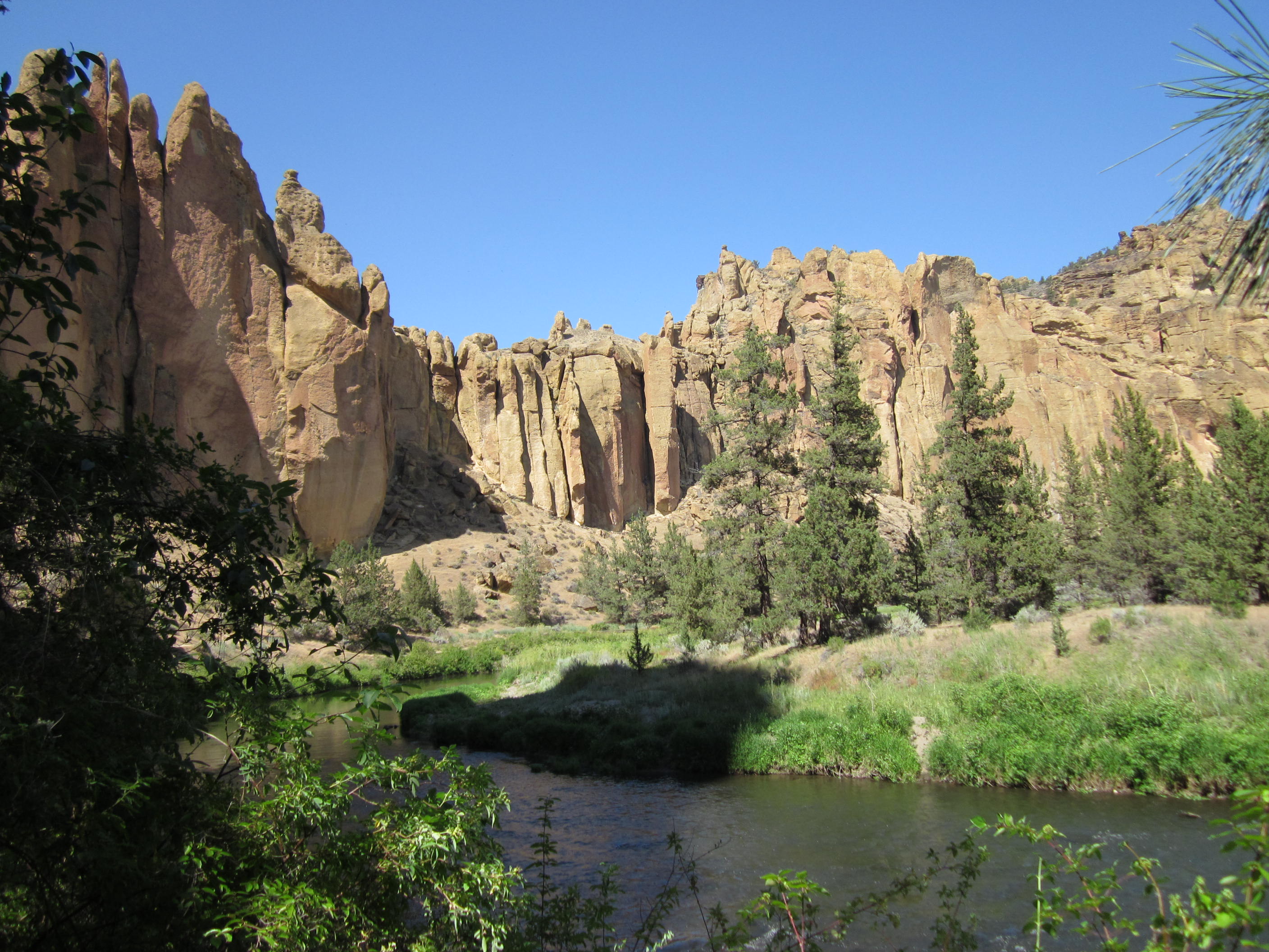

Twenty-six miles north of Bend, the high desert does something abrupt. The flat sagebrush plateau ends, and the Crooked River has cut a canyon into it lined with orange and buff cliffs several hundred feet high.
Smith Rock State Park is one of the most important pieces of ground in American climbing history and one of the best short hikes in Oregon, and those two facts are less related than you might think, because you can see all of it on foot.
What the rock is
The walls are welded tuff, and the distinction matters. Roughly 30 million years ago a caldera eruption blanketed this area in searingly hot volcanic ash, and where the ash landed thick and hot enough the fragments fused together under their own heat and weight into a hard, compact rock. The Crooked River then cut down through it, exposing the walls you see.
Welded tuff is unlike granite, because it is featured with small pockets and edges rather than cracks, which is precisely why the climbing here developed the way it did: there is often nowhere to place traditional protection, so routes had to be bolted. The darker rock along the river bottom is younger basalt, which is why the canyon has two distinct bands of color.
Why climbers care
In the mid-1980s Alan Watts began establishing routes here using bolts placed on rappel rather than from the ground up, a practice that was controversial to the point of hostility in American climbing at the time and standard practice in Europe. The routes that resulted were harder than almost anything then existing in the United States, and To Bolt or Not to Be, established in 1986, is widely credited as the first 5.14 in the country.
Sport climbing spread from here across the US. The park now holds well over a thousand routes, and on any decent weekend the walls are covered in people. For a hiker this is a spectator sport and a good one, because the trails run directly beneath the main walls and you will spend a lot of the day watching climbers a hundred feet above your head.
Misery Ridge
The hike everybody comes for, and the name is earned but slightly oversold. The standard loop, Misery Ridge to Mesa Verde to the River Trail, runs roughly 3.6 to 4 miles with about 900 to 1,000 feet of gain, and it is one of the highest-value short hikes in Oregon.
It begins with a steep descent from the rim parking lot to the river, which means the hard climbing is in the middle and the last thing you do is walk back up out of the canyon, and people forget this. Misery Ridge itself is the climb: relentless switchbacks and steps up the ridge with no shade whatsoever, around 700 feet in well under a mile, and in July at midday it is punishing.
At the top you arrive level with Monkey Face and the reason for the whole exercise becomes obvious. Monkey Face is a free-standing 350-foot tower of welded tuff that, from the right angle, is unmistakably a monkey's head in profile, with a cave for a mouth, and climbers reach the summit by a route that goes through it.
The descent from the ridge drops steeply on the far side to the river, and the River Trail returns flat and easy along the water beneath the main walls, which is the best part of the walk and the part people are too tired to appreciate.
The easier options
Not everybody needs 900 feet of shadeless switchbacks. The River Trail on its own is flat, follows the Crooked River beneath the climbing walls, and can be walked out and back for any distance you like, which makes it the best easy walk in the park and gives you most of the scenery. The Canyon Trail and Wolf Tree Trail extend the flat riverside walking downstream into quieter country.
The rim viewpoints by the parking lot require almost no walking and give the classic overview of the whole formation. Burma Road is the alternative climb, a steep old road grade up the other side, less scenic than Misery Ridge and far quieter, and the Summit Trail Loop extends the walk for a longer day.
The canyon below the park
One thing worth adding to a day here, because almost nobody does it. The Crooked River continues downstream from the park through a deepening canyon, and the flat trails on that side, meaning Wolf Tree, Burma Road's lower reaches and the river path beyond the main climbing area, carry a fraction of the traffic of the Misery Ridge circuit while running through the same landscape. Within twenty minutes of walking downstream you are usually alone, with the walls above you and the river beside you, and the noise of the main area gone entirely.
It is also the best wildlife stretch in the park. Otters work the river, beaver sign is common along the banks, and mule deer come down to drink morning and evening, while the cliff swallows and white-throated swifts nesting on the walls put on a display over the water at dusk that is worth staying for. The Crooked River itself is a redband trout fishery of some reputation, running clear and cold through the middle of the desert.
This is the walk to do in the heat of the afternoon, when Misery Ridge is a bad idea and the canyon bottom holds what shade exists.
The conditions are the whole planning problem
Smith Rock is high desert at around 3,000 feet, and the climate is unforgiving in both directions. Summer is dangerous, because temperatures routinely exceed 95°F, there is no shade anywhere on Misery Ridge, and the rock radiates heat back at you, so heat illness here is a regular occurrence and if you must come in July or August you should be walking at sunrise and finished by ten.
Spring and autumn are ideal, March through May and September through November, which is also when the climbing season peaks, so the park is busy. Winter is excellent and underrated, being cold, clear, often sunny and nearly empty, with ice on the shaded switchbacks the hazard. The wind funnels through the canyon and can be fierce on the ridge, and rattlesnakes are present and common on the warm rock from spring through autumn, along with ticks.
One seasonal constraint is unusual enough to name. Golden eagles, prairie falcons and peregrines nest on the walls, and seasonal climbing closures protect the nests each spring, applying to specific routes and specific faces rather than to the park or the trails. That is about as granular as an access rule gets: a closure on one wall, for part of the year, that does not affect the hiker walking beneath it. Guidepole Hike carries closures and access status at that level alongside the routes, which at a park where the rules differ between the trail and the rock above it is the only way to hold both.
Hiking the Misery Ridge Trail in Smith Rock State ParkHow it became a park
Smith Rock became a state park in 1960, and the standard account of the name is that it commemorates a soldier named Smith who died at the site in the 1860s, though versions differ and a competing story credits a different Smith entirely.
What matters more is that the park existed for two decades as a quiet local picnic spot before the climbing arrived. In the 1960s and 1970s a small number of climbers worked the obvious crack lines, and it was the 1980s bolt-protected face climbing revolution that turned a modest Oregon state park into an internationally known destination, with the park's infrastructure catching up ever since.
That history is visible on the ground. The parking lot, the toilets and the bivouac campground are all sized for a place that did not expect to become famous, and the park now manages a volume of visitors its original design never contemplated, with parking overflow, trail erosion on Misery Ridge and human waste in the canyon all ongoing and openly discussed problems. The Smith Rock Group, a volunteer organization, does a substantial share of the trail and route maintenance, and the park runs regular work parties.
The gear
Smith Rock is a high desert canyon with a very steep trail in it, and everything here follows from heat and exposure.
Far more water than the mileage suggests, which is the item that generates the rescues. Misery Ridge is under four miles round trip and it climbs a thousand feet on an unshaded south-facing slope in a place that reaches the nineties, and short distance plus high heat is exactly the combination people underestimate.
A sun hat and high-SPF sunscreen, since there is essentially no shade in the park.
An early start, for the same reason. Seven in the morning at Smith Rock is pleasant and one in the afternoon is not.
Trekking poles, for the descent off the back of the ridge, which is steep and loose.
An Oregon day-use parking permit, required and enforced.
Binoculars, which are worth carrying here for two reasons: the golden eagles that nest on the walls, which is why sections of the park close seasonally to climbing, and the climbers themselves, who are visible on routes across the canyon and are a large part of what makes the place interesting.
And microspikes in winter, because the trail ices on the shaded upper sections and people fall on it.
The high desert around it
It is worth knowing what you are standing in, because the ecosystem is different from anything else on this coast. Western juniper is the dominant tree, gnarled, slow-growing and enormously long-lived, with individuals in central Oregon over a thousand years old, and juniper has expanded dramatically across the region since fire suppression began, at the expense of the sagebrush steppe.
Big sagebrush and bitterbrush fill the flats, and the sharp resinous smell after rain is the defining scent of the high desert. The ground between them is bunchgrass rather than turf, with bare earth in the gaps, which is why staying on trail matters so much here: the biological soil crust between the plants is a living community of cyanobacteria, lichens and mosses that holds the surface together and takes decades to recover from a single footprint.
The Misery Ridge Loop Trail, Smith Rock State ParkWatching climbing without getting in the way
Since a good part of the day is spent under other people's ropes, a few conventions are worth knowing. Stay on the trail beneath the walls, because the ground at the base of a climbing route is a working area with ropes, gear and belayers who cannot look away from the climber. Do not walk between a belayer and the wall, and do not step over a rope.
Rockfall is real, and helmets exist for a reason while hikers are not wearing them, so if someone shouts "rock", move toward the wall rather than away from it and do not look up. Do not shout encouragement or ask questions mid-route, because a climber working a hard sequence is concentrating and the belayer is the only person who should be talking to them. On photographs of strangers, climbers are generally relaxed about it, but asking is better than a long lens. And dogs at the base of routes are a common source of friction, so keep them leashed and close or leave them behind.
None of this is precious. It is the same courtesy you would want walking through anyone's workplace, and the climbing community here has been unusually generous about sharing a small park with a very large number of hikers.
Practical notes, and where to start
A day-use parking permit is required, and the charge at the time of writing is $10 for in-state visitors, $12 out-of-state and $60 for a resident annual pass. Oregon reprices these, so check the current figure with Oregon State Parks rather than arriving with exact change, with the comparison in six states, six ways to charge you for a trailhead. Parking fills early on spring and autumn weekends and the overflow arrangements are tight. The bivouac campground is walk-in, first come first served, and aimed at climbers, with no vehicles at the sites.
Dogs are allowed on leash, which is welcome given Oregon's generally good record, though the ground is hot and abrasive and there is no water on the ridge. Carry all your water, because there is none on the trail and the river is not a substitute. And Terrebonne has minimal services, so Redmond and Bend are the bases.
For the walking: one hour gets you the rim viewpoints and a stretch of the River Trail. Two to three hours gets the full Misery Ridge loop, which is the reason the park is famous, done early in the day. A flat afternoon is the River Trail downstream and back, watching climbers. And winter is any of the above, in the cold and sun, with the park to yourself.
Whatever you do, look up. There is a reasonable chance you will be standing underneath somebody working a route that changed the sport.
Bend is half an hour away and covered in day hiking Bend, with the volcano above it at South Sister. Oregon's waterfall park is the Trail of Ten Falls, the coast is hiking the Oregon Coast, and the Crooked River's fishing neighbor is the lower Deschutes.
The town twenty minutes south is in Bend Oregon day hikes and the volcano above it in hiking South Sister. The wet side of the state is in Silver Falls and hiking Portland. The nesting closures on the walls work exactly as described in nesting and seasonal closures explained, and the parking permit is in state park passes by state.