Fish
Fish Fire
Fire Hike
Hike Bird
Bird

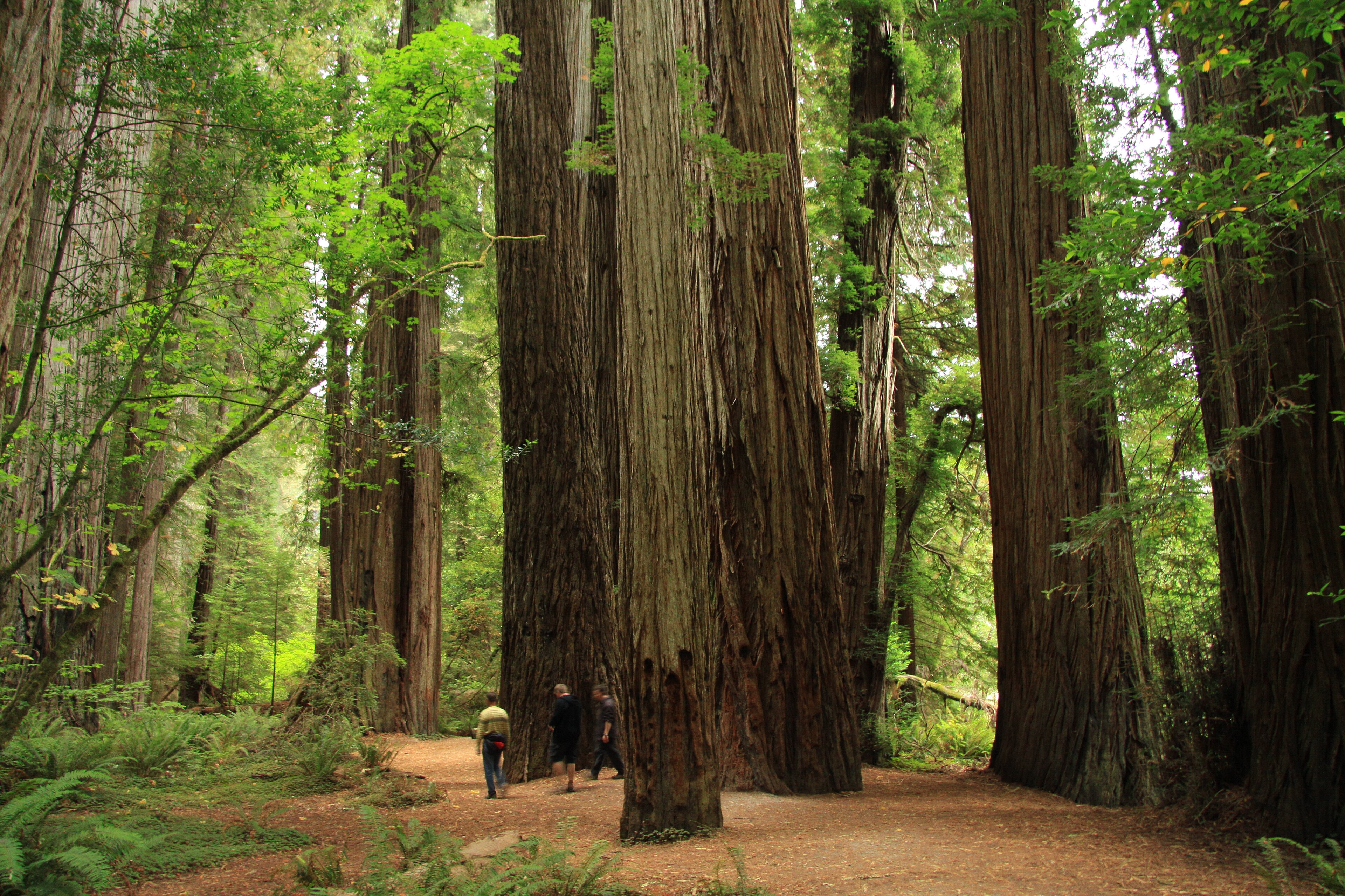

There is a six-mile gravel road in the far northwestern corner of California that runs directly through the densest old-growth redwood forest on Earth.
Howland Hill Road is one lane, unpaved, and passes within a few feet of trees more than eighteen feet in diameter. There is no entrance station, no fee booth, and for most of its length no signage of any kind.
It is the best redwood experience available from a vehicle, and it is the way into Jedediah Smith Redwoods State Park.
The densest forest
Redwood forests are usually described by height, because the tallest trees on Earth are coast redwoods. Jedediah Smith is remarkable for density instead, because by measures of standing biomass per acre the old growth here is among the highest anywhere on the planet, greater than tropical rainforest by a wide margin. The trees are enormous and there are a great many of them close together.
The reason is the Smith River and its climate. This is the wettest corner of California, the river is undammed and runs exceptionally clear, and the alluvial flats along it hold deep rich soil. The Smith is the largest completely undammed river system in California, which is increasingly rare, and it is designated Wild and Scenic along most of its length.
Howland Hill Road
The road runs roughly six miles between Crescent City and the Highway 199 corridor near Hiouchi. It is unpaved, single lane with pullouts, and slow, so allow forty minutes without stopping and considerably more with. No RVs or trailers, because the road is too tight and vehicles get stuck. And it is open year-round in normal conditions, though storms bring down trees and it closes periodically.
Driving it is an experience in itself. The canopy closes overhead, the light goes green, and the trunks are close enough on both sides that you slow to a crawl instinctively.
It is also, administratively, an oddity worth knowing. The best road in the park has no entrance station and Stout Grove at the end of it costs nothing, while day-use fees apply at the developed area off Highway 199, and the whole park is co-managed with Redwood National Park so you will see both state and federal signage without any indication of where one becomes the other. Guidepole Hike carries the managing agency and what each access point requires, which here saves paying for something you can reach for free from the other direction.
The walks
Stout Grove is the essential one, a half-mile flat loop through an extraordinarily open, cathedral-like stand on the flats beside the Smith River. The understory is sparse because of periodic flooding, which means you can see between the trunks for a considerable distance, and the effect is very different from the dense fern-and-sorrel floor of most redwood groves. It is widely considered the finest single redwood grove anywhere, and it is ten minutes from the road.
The Boy Scout Tree Trail is the best walk in the park, roughly 5.5 miles round trip, gently undulating through unbroken old growth to the double-trunked Boy Scout Tree and on to Fern Falls. It has no views and no summit, and it is one of the best forest walks in the United States.
Beyond those, Simpson-Reed Grove is a short flat loop off Highway 199 with dense understory, Mill Creek Trail follows the creek through more old growth, and the Hiouchi and Hatton trails connect the visitor center area. In summer a seasonal footbridge crosses the Smith River from the campground to Stout Grove.
Little Bald Hills
The park's strangest trail deserves more attention than it gets. The Little Bald Hills Trail climbs from the Howland Hill Road area out of the redwoods and onto a plateau of serpentine soil, where the forest stops.
Serpentine is low in calcium, high in magnesium and heavy metals, and hostile to most plants, so what grows instead is open prairie, Jeffrey pine and a specialized flora including species restricted to serpentine. The transition happens over a few hundred yards and it is abrupt enough to be disorienting: dense towering rainforest, then open sunny grassland with scattered pines, on the same hillside.
It is about seven miles round trip, with camping available, and it continues toward the Smith River. It is the best illustration anywhere in the redwoods of how much the soil determines the forest.
The Smith River, and the fishery
The water is extraordinarily clear, an intense green-blue in the deep pools, and the reason is geological, because the catchment is largely serpentine and other rock that yields very little fine sediment. Swimming in summer is excellent, cold, and popular at the gravel bars near the campground.
Because the river is undammed it does something almost no other California river still does. Winter steelhead run the Smith in numbers and sizes that draw anglers from across the country, and the river holds a reputation for producing exceptionally large fish, while fall chinook run in autumn and coho are present though far reduced. The clarity that makes the river beautiful also makes it difficult to fish, and it drops and clears faster after rain than almost any river on the coast, because the catchment sheds water quickly and produces little suspended sediment. Access is largely from Highway 199 and the state park, and the river is managed with seasonal regulations that change.
For a hiker the relevance is this: the river you are looking at is what a Californian river looked like before dams, and there is essentially nowhere else you can see that at this scale. Jedediah Smith, the park's namesake, was an American trapper and explorer who passed through this area in 1828, the first non-native to reach California overland from the east.
The Tolowa
This coast is the homeland of the Tolowa Dee-ni', and the history here is more violent and more recent than most visitors realize. The Tolowa lived in permanent villages along the Smith River and the coast, in a society built on salmon, smelt, acorns and shellfish, with plank houses and extensive trade.
Following the gold rush and American settlement in the 1850s, the Tolowa were subjected to a series of massacres, the worst of which took place at the village of Yontocket in 1853 during a ceremonial gathering, with estimates of the dead running into the hundreds, and further massacres followed at other village sites. The population fell catastrophically within a decade, survivors were removed to reservations, and the language came close to extinction.
The Tolowa Dee-ni' Nation is federally recognized today, based at Smith River, and is engaged in language revitalization, land reacquisition and fisheries management on the river. Yontocket is now within Tolowa Dunes State Park, north of the redwoods, and it is a sacred site rather than a visitor attraction.
It is worth knowing while walking through Stout Grove that the emptiness of this landscape is not natural. People lived here in large numbers and were killed and removed within living memory of the trees standing around you, which have been there for a thousand years and more.
The Boy Scout Tree Trail, Jedediah Smith Redwoods State ParkGetting the light right
Old-growth redwood is among the harder subjects to photograph and this park is the hardest of them, because the density that makes it special also makes it dark.
Overcast or fog is what you want, since direct sun through a redwood canopy produces extreme contrast that no sensor handles, with blown highlights in the gaps and black shadow everywhere else. Early morning fog in Stout Grove, with light beams through the trunks, is the image everyone is after, and it happens most reliably in summer when the marine layer pushes inland overnight. Rain is fine too, because the colors saturate, the bark darkens and the sorrel glows.
A tripod is close to mandatory at ground level. Include something for scale or the photograph will not communicate anything, whether a person, a trail or a bench, because without it a 300-foot tree looks like a 30-foot tree. And either shoot upward from close to the trunk for the converging-verticals effect, or step well back and shoot the grove structure instead.
Stout Grove's open floor makes it the most photographable old-growth grove in California, which is a large part of why it is so widely reproduced.
The gear
Jedediah Smith is the northernmost redwood park and the one with the least infrastructure, and the gear list starts with the road in.
A vehicle that fits Howland Hill Road, which is the single most important item. It is a narrow unpaved one-lane road through old growth with trees close on both sides, there are length restrictions, and motorhomes and trailers cannot use it. It is also the best redwood drive in the state.
Rain gear, for a place that receives around eighty inches a year.
A tripod, for the same low-light reason as in any grove.
Swimming things in summer, which is an unusual entry on a redwood list and belongs on this one. The Smith River is the largest undammed river in California, the water is startlingly clear, and the swimming holes below Stout Grove are the best of any redwood park.
Sturdy shoes, for the Boy Scout Tree Trail, which is muddy and rooted rather than groomed.
Offline maps, since coverage in the park is nil.
And time, because this park is far from anywhere. Crescent City is the nearest town of any size and it is a long drive from any airport, which is precisely why Jedediah Smith is the quietest of the three.
The other two redwood state parks
Jedediah Smith is one of three, and the full set makes a good two-day route. Del Norte Coast Redwoods State Park sits between here and Prairie Creek, with old growth running right down to the ocean, and the Damnation Creek Trail drops steeply through it to a rocky cove as one of the best and hardest short walks in the redwoods, though it has been affected by trail closures in recent years. Prairie Creek Redwoods State Park holds Fern Canyon, Gold Bluffs Beach and the elk.
Redwood National Park land wraps around all three, including the Tall Trees Grove, which requires a free permit with a daily cap and a steep hike, and the Lady Bird Johnson Grove, an easy loop with a road right to it.
Driving north to south from Crescent City you can do Jedediah Smith in the morning, Del Norte in the middle of the day and Prairie Creek in the afternoon, which is a good deal of the world's remaining old-growth redwood in a single day.
Hiking the Boy Scout Tree Trail and Stout GroveSeason, and practical notes
Summer is dry, busy by local standards, and the river swimming is the draw. Winter and spring are wet, and this is the wettest part of California with some locations receiving over a hundred inches a year, and the forest is at its best in it. Autumn is the sweet spot, being dry, quiet and cool, and fog is common in summer and part of how the trees survive the dry season.
Camping at Jedediah Smith Campground, on the river, books six months ahead and is one of the better redwood campgrounds. Dogs are restricted to roads and campgrounds rather than trails, as across California. Crescent City is fifteen minutes west with services, and the park is about six and a half hours north of San Francisco or an hour and a half south of the Oregon border towns. Signal is absent in the forest. And elk are present but far less visible than at Prairie Creek.
What to do with a day
Drive Howland Hill Road from the Crescent City end, slowly, with the windows down. Stop at Stout Grove and walk the half-mile loop, ideally in early morning light or in rain. Walk the Boy Scout Tree Trail, five and a half miles, which is the reason to give this park a full day rather than an hour. And finish at the Smith River for a swim if it is warm, or just to look at the water.
If you have been to the more famous redwood parks and found them crowded, note that this one is six hours from San Francisco, has no entrance station on its best road, and holds the densest ancient forest on the planet.
More redwoods at Humboldt Redwoods, Fern Canyon and Big Basin. The rules across the region are in six states, six ways to charge you for a trailhead.
The other redwood parks are in Prairie Creek and Fern Canyon, Humboldt Redwoods and Big Basin after the fire. The Oregon coast twenty minutes north is in the Samuel Boardman corridor and Oregon coast hiking. The pass structure is in state park passes by state.
A note on why this grove survived when almost all the rest did not. Ninety-five percent of the original coast redwood forest was logged, and what is left is left mostly because somebody bought it in time. Stout Grove was donated by Clara Stout in 1929 in memory of her husband, a lumberman. The Save the Redwoods League has been buying groves parcel by parcel since 1918 and still is. The old growth you are walking through is not wilderness that was overlooked, it is a purchase.