Fish
Fish Fire
Fire Hike
Hike Bird
Bird

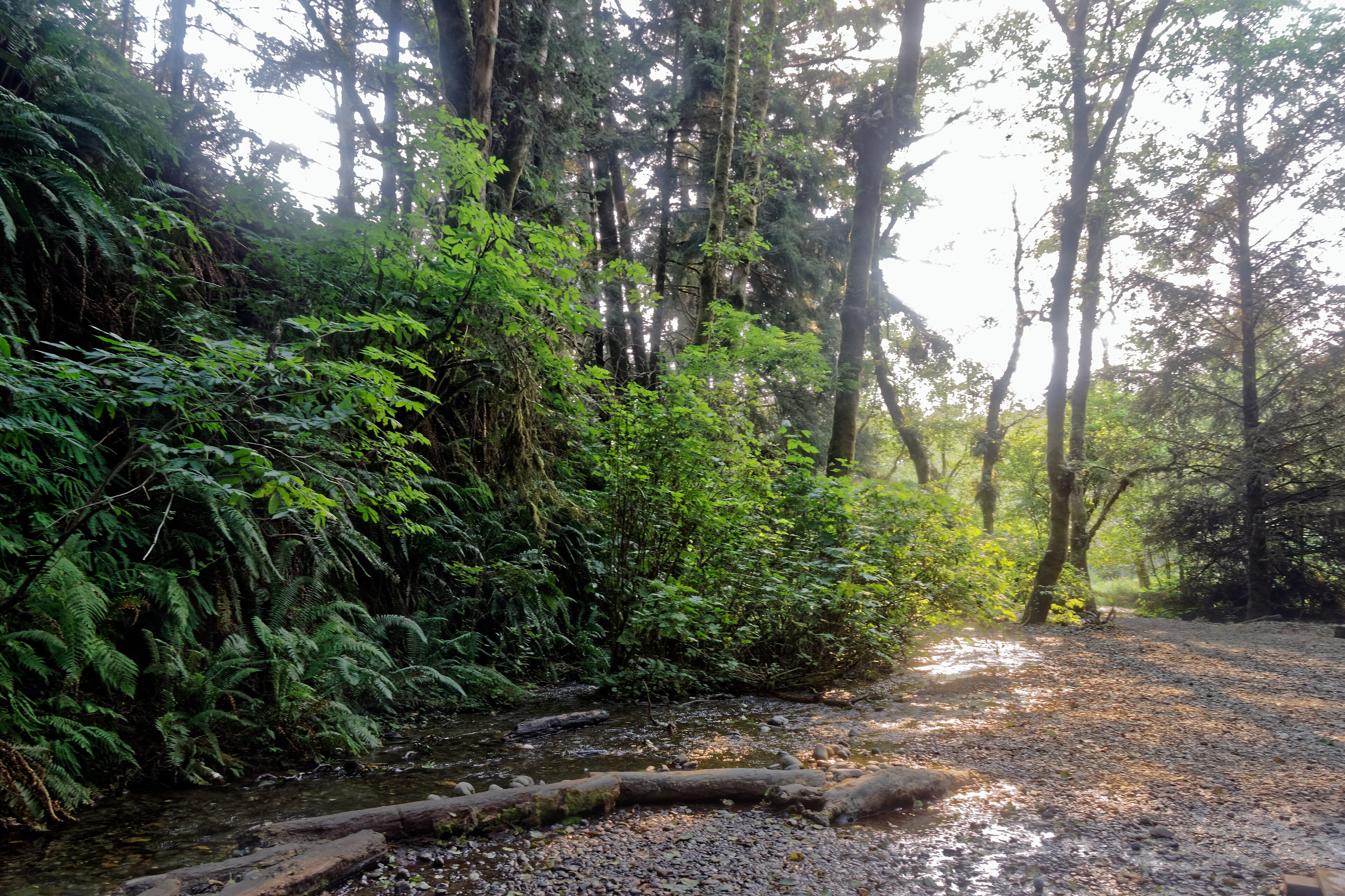

Fern Canyon is about half a mile long, has a creek running down the middle of it, and vertical walls up to fifty feet high covered from floor to rim in ferns.
Seven species grow on them, including five-fingered fern, lady fern and sword fern, along with mosses and liverworts. The walls stay wet because water seeps out of the sediment continuously, which is the entire reason the ferns are there.
It looks prehistoric, which is why Steven Spielberg filmed part of The Lost World: Jurassic Park here in 1996, for release the following year. It is also, since 2022, one of the harder places in California to get into.
The permit
This is the practical thing and there is no way around it. Between May 15 and September 15 a permit is required to reach the Fern Canyon trailhead or the Gold Bluffs Beach day-use area, permits must be reserved in advance, and they are limited.
The reason is simple. The access road is a narrow unpaved single-lane road with creek fords, the parking is tiny, and the canyon itself is a fragile half-mile slot that was receiving numbers it could not absorb, with vehicles waiting in line on the road and people walking on the fern walls.
Outside the permit window the canyon is open without one, though the road can be closed by weather and the footbridges over the creek are removed for winter, which changes the walk considerably. Check current arrangements before traveling, because this system is recent and it has been adjusted.
Getting there is part of it
Davison Road runs about seven miles from Highway 101 to Gold Bluffs Beach and then on to the Fern Canyon trailhead. It is unpaved, narrow, and includes creek crossings that are shallow in summer and can be impassable after rain.
Vehicle restrictions apply and they catch people out constantly: no trailers, no RVs over 24 feet, and a width limit of 8 feet. The drive itself is good, dropping through forest onto a beach backed by bluffs, with elk frequently on the road.
The canyon walk
Short, wet, and unlike anywhere else. It is roughly a mile round trip if you walk up the canyon and back, or about 1.1 miles as a loop using the trail that climbs out at the top and returns along the rim.
You will cross the creek repeatedly. In summer the footbridges are installed and the crossings are straightforward, while outside the season the bridges are gone and you are wading, so wear shoes you are willing to soak, which is not optional at any time of year.
The walls are the point, so look up and look closely, because the fern species change with height and moisture and the seeps are visible. Do not touch or climb them: they are the resource, they are fragile, and the damage is obvious and permanent. And note that as of 2026 work has been underway on the stairs connecting Fern Canyon to the James Irvine Trail, so the loop may not be complete, which is worth checking before planning it.
The rest of Prairie Creek
The canyon is famous and the park around it is better, which is the single most useful thing in this article. Prairie Creek Redwoods State Park is one of three state parks jointly managed with Redwood National Park, and the trails around Fern Canyon are where the actual forest is.
The James Irvine Trail runs roughly four and a half miles from the visitor center through some of the finest old-growth redwood anywhere, descending to Fern Canyon, and combined with the Miners Ridge Trail it makes a loop of about 11 miles that is arguably the best day hike in the redwoods. The Prairie Creek Trail follows the creek through the heart of the old growth with almost no elevation change, and the Cathedral Trees Trail and Foothill Trail offer flat old-growth walking near the visitor center. Big Tree Wayside is a short accessible walk to an enormous individual redwood.
Further out, the Ossagon Trail drops from the parkway to the beach at the park's northern end, a quieter way to reach the coast than Davison Road, and the West Ridge Trail climbs to give a different forest structure on the slopes. Trillium Falls, technically just outside in the Redwood National Park section, is a 2.5-mile loop to a small waterfall through excellent forest and is the best short walk in the area that nobody lines up for. Gold Bluffs Beach itself runs for miles beneath eroding bluffs, with a campground and elk on the sand, and Elk Prairie at the park entrance is where the herd is most reliably seen.
The Newton B. Drury Scenic Parkway is the old highway alignment running ten miles through the park, and driving it slowly with stops is the equivalent of Humboldt's Avenue of the Giants.
The elk
Roosevelt elk are the largest subspecies of elk in North America, and Prairie Creek holds one of the most visible herds anywhere. They are on the prairie at the entrance, on Gold Bluffs Beach, and frequently on the road.
They are not tame. Bulls in the autumn rut, roughly September into October, are aggressive and unpredictable, and cows with calves in spring are equally dangerous, and people are injured here by getting too close for photographs. Give them a very wide berth and stay in your vehicle when they are on the road.
Seeing a herd of elk on a beach beneath redwood-covered bluffs is one of the more remarkable wildlife scenes in the United States, and it is available from a parking lot.
How the parks got joined together
The co-management arrangement here is unusual enough to explain. California protected the best remaining redwood groves as state parks through the 1920s and 1930s, largely through the Save the Redwoods League, and Prairie Creek, Del Norte Coast and Jedediah Smith all date from that period. By the 1960s, logging of the remaining private old growth was accelerating dramatically and a national campaign pushed for federal protection of what was left.
Redwood National Park was created in 1968 and substantially expanded in 1978, bringing in heavily logged watershed land above the existing groves specifically to stop upstream erosion from destroying them. That left a patchwork: federal park land wrapped around and between three existing state parks, with two agencies, two sets of rules, two staffs and two budgets covering one forest. In 1994 they formally agreed to manage the whole thing jointly as Redwood National and State Parks, with shared staff and unified planning.
It has worked well enough to be cited as a model, and it is why you will see both state and federal signage, why a single visitor center covers both, and why the boundary between state and federal land is essentially invisible on the ground. The expansion also began one of the largest watershed restoration projects ever attempted, removing hundreds of miles of logging road to stop sediment reaching the creeks.
That invisibility is convenient until it is not, because the rules did not merge along with the management. Dog rules, camping and the Fern Canyon permit follow whichever agency owns the specific parcel, and a walk from the visitor center to the beach can cross the line more than once without any sign saying so. Guidepole Hike carries the underlying ownership and its rules against the trail, which in a park deliberately designed to look seamless is the layer the signage no longer shows you.
The Fern Canyon HikeGold Bluffs
The beach the road runs along has a name for a reason. Gold was found in the black sand here in 1850 and a short, frantic rush followed, because the bluffs behind the beach contain gold in very fine particles, released as they erode and concentrated by wave action into dark heavy-mineral layers on the sand.
The problem was that the gold was too fine to recover economically with the methods available. Companies tried repeatedly for decades, including hydraulic mining of the bluffs themselves, and largely failed.
What remains is the name, some scattered relics, and the eroding bluffs that still shed a little gold onto the beach every winter. The elk, which are the reason most people remember Gold Bluffs, are indifferent to all of it.
The gear
Fern Canyon is a creek bed with fifty-foot fern-covered walls, and you walk up the creek, which sets the first item.
Shoes you will soak, because the route is the stream. There are seasonal footbridges in summer and none the rest of the year, and trying to keep feet dry here wastes an hour and fails anyway.
A booked permit, which is required for Fern Canyon and Gold Bluffs Beach from May through September, is limited by day, and is the thing that catches people who drive up expecting to walk in.
A vehicle that fits the restrictions, which is the other thing that catches people. Davison Road has a length and height limit and it fords a creek, so motorhomes and trailers cannot get in at all.
Rain gear, for a coast that is wet most of the year.
A warm layer, because the canyon holds cold air and never sees direct sun.
Distance from the elk, which is a genuine safety item rather than an etiquette one. The Roosevelt elk on Gold Bluffs Beach are large, habituated and unpredictable in the autumn rut, and people are injured by them.
And time for the James Irvine Trail, which is the better hike and which most visitors skip in favor of the canyon alone.
The banana slug and the forest floor
Worth a paragraph because you will meet a great many of them. Banana slugs reach up to nine inches, come in yellow, green, brown and spotted, and are the second-largest terrestrial slug species in the world.
They are decomposers, eating leaf litter, fungi and animal droppings and converting it into soil at a rate that matters in a forest producing this much litter. They also eat the competitors of redwood seedlings while reportedly avoiding the seedlings themselves, which is a small ecological favor.
The slime is a genuine defense, because it contains an anesthetic that numbs the mouths of predators, which is why picking one up leaves your fingers feeling odd and why very little eats them. Do not put salt on them, do not pick them up unnecessarily, and watch where you step on a wet morning, because the trail can be covered.
Tsunami awareness on this coast
Worth knowing on any northern California beach. The Cascadia Subduction Zone offshore produces very large earthquakes at intervals of several hundred years, and this stretch of coast sits close to its southern end near the Mendocino Triple Junction, one of the more seismically active spots in the contiguous United States.
A local tsunami would arrive within fifteen to twenty minutes of the shaking, faster than any warning could reach you, so the rule is that a long rolling earthquake on the coast means moving inland or to high ground immediately, on foot.
At Gold Bluffs Beach this is a real consideration, because the beach is backed by bluffs and the access road runs along the shore, and evacuation routes are signed. Inland, Fern Canyon itself is at low elevation on a creek running to the sea. It is one thing to know once rather than something to worry about repeatedly.
The James Irvine Trail and Miners Ridge Through Fern CanyonSeason, and what to do with a day
Summer is the permit season, the driest weather and the busiest. Spring and autumn are excellent, with fewer people and the permit requirement lifted at the shoulders. Winter is wet, the footbridges are out, the road may close, and the canyon is at its most atmospheric if you can get to it. Fog is common and the coast here is cool year-round.
The practical picture is straightforward. Permits run May 15 to September 15, booked in advance, day-use fees apply, and a Golden Poppy annual pass at $125 covers most California day use. Camping at Elk Prairie and Gold Bluffs Beach books six months ahead. Dogs are restricted to roads and campgrounds rather than trails, as across the California system. It is about five and a half hours north of San Francisco and forty minutes north of Eureka, Orick is the nearest settlement and it is very small, and signal is poor to absent.
So: book the permit first if you are traveling in the window. Drive Davison Road early and slowly, watching for elk. Walk Fern Canyon, an hour, in wet shoes. Then walk the James Irvine Trail back toward the visitor center, or as far as you like, because the old growth on that trail is better than the canyon and almost nobody who comes for Fern Canyon ever sees it.
More redwoods at Humboldt Redwoods and Jedediah Smith, and the post-fire story at Big Basin. California's access rules are in six states, six ways to charge you for a trailhead.
The other redwood parks are in Jedediah Smith Redwoods, Humboldt Redwoods and Big Basin after the fire. The Oregon coast immediately north is in the Samuel Boardman corridor. The permit system here is the kind described in hiking permit lotteries explained, and the pass structure is in state park passes by state.