Fish
Fish Fire
Fire Hike
Hike Bird
Bird


There is a stone tower on top of Mount Constitution that looks as though it belongs on a hillside in the Caucasus, which is exactly where its design came from.
It stands at 2,407 feet, and what makes that number remarkable is that the mountain starts at sea level about two miles away. It is the second-highest point on any ocean island in the contiguous United States, with only Devils Peak in California's Channel Islands higher, and it is the highest in the San Juans by a very long way.
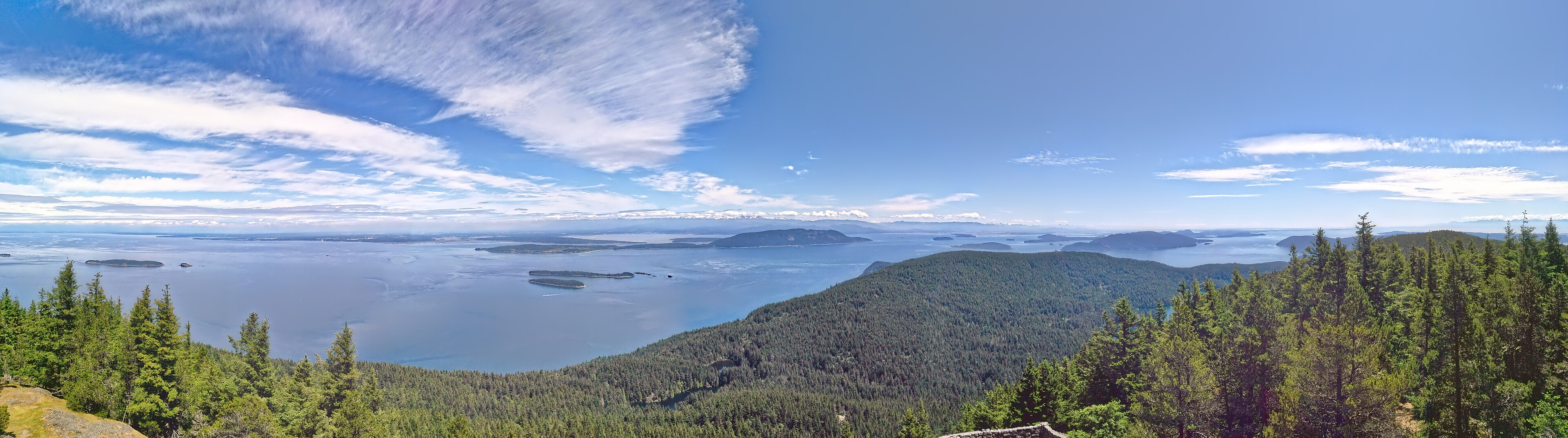
From the top you can see the whole archipelago, Vancouver Island, the Canadian mainland, Mount Baker, Mount Rainier on a clear day, and the Olympics.
Robert Moran, and why the park exists
Moran State Park is named for Robert Moran, a Seattle shipbuilder and former mayor of the city who moved to Orcas Island in 1906 after being told he had a short time to live. He was misinformed, and lived another thirty-seven years.
Moran built Rosario, an elaborate mansion on the island, and accumulated a very large holding of land, and in 1921 he donated nearly 2,700 acres to Washington State, which formed the core of the park. It has since grown to roughly 5,400 acres, making it one of the largest in the Washington system. The Civilian Conservation Corps did the rest during the 1930s, and their work is everywhere: the road to the summit, the trail network, the picnic shelters, the bridges, and the tower itself.
The tower
The Mount Constitution observation tower was built by the CCC in 1936, designed by the architect Ellsworth Storey, who based it on twelfth-century watchtowers in the Caucasus. The result is a squat, round, crenellated stone structure that looks nothing like anything else in the Pacific Northwest, sitting on a rock summit above the sea.
You climb an internal stair to an open viewing level. It is free, it is open in season, and it is one of the best-value viewpoints in the state.
Getting up the mountain
There are two honest answers. You can drive, because a paved road runs to the summit and a great many visitors do exactly that, and there is no shame in it because the view is the same.
Or you can walk it. The full climb from the Cascade Lake area is roughly 6.7 miles round trip with about 1,500 feet of gain, or longer if you take the Mountain Lake and Little Summit loop, which runs closer to 8 or 9 miles and is the better route. The walking is forested for most of the way, opening near the top, and it is a steady climb rather than a steep one, on good trail. Little Summit is a viewpoint below the main peak on the eastern side and is worth including.
The rest of the park
The summit gets the attention and the park has 38 miles of trail. Cascade Falls is the best short walk, a 100-foot waterfall reached in a few minutes from a small parking area and running hardest in spring, with Rustic Falls and Cavern Falls on the same creek. The Cold Springs Trail climbs the western side.
The lakes are the other half, and they are glacial, sitting in basins scoured out of bedrock by ice that covered these islands to a depth of over a kilometer. Mountain Lake is the larger and higher, cold and deep, with a four-mile loop around it that is quiet, level, through second-growth forest, and the best easy walk in the park. Cascade Lake is lower and warmer and holds the swimming beach and the main campground, with a shorter loop. And Twin Lakes sit higher still, reached from the Mountain Lake trail, and are the quiet ones.
Both main lakes hold trout and the park allows fishing with a state license. What you will not find is the thing people expect from an island, because there are no salmon streams of consequence here: the drainages are short and steep and the lakes are impounded, so the marine life is offshore and the freshwater life is separate. Mountain biking is permitted on some trails seasonally, which is unusual for a Washington state park and worth checking if you ride.
The islands, which are the real subject
Understanding what you are looking at from the tower makes the climb better. The San Juan Islands are the tops of a drowned mountain range, because during the last glaciation this whole area was buried under ice more than a kilometer thick, which scoured the bedrock, and when the ice melted the sea rose and flooded the valleys, leaving the ridges as islands. The rock is old and complex, an assemblage of terranes accreted onto the continental margin over hundreds of millions of years.
Orcas is the largest of them by area, shaped like a saddlebag, with Mount Constitution filling the eastern lobe. As for whales, the endangered southern resident orcas and the more numerous transients both use these waters, and from the tower you are looking down on their habitat, though you will not see them from up there.
The forest, and what was taken from it
The forest you walk through on the way up Mount Constitution is almost entirely second growth, and the reason is the same one that explains most of Puget Sound. The San Juans were logged hard through the late nineteenth century, first for ship timber and building material, then for lime kilns, and San Juan Island in particular had a major lime industry where burning limestone into quicklime consumed enormous quantities of cordwood. Whole islands were stripped. What regrew is Douglas fir, western hemlock and western red cedar, now roughly a century old and substantial, with pockets of older trees that were missed.
The rain shadow shapes it further. The islands sit in the lee of the Olympics, so Orcas gets far less rain than the mainland Cascades and is drier and sunnier than Seattle, which makes the forest more open than a comparable elevation on the west slope, with Pacific madrone and Garry oak on the sunny rocky ground.
Garry oak savanna is one of the rarest habitats in the Pacific Northwest. It was maintained for millennia by Coast Salish burning, which kept the understory open for camas harvest, and it has largely disappeared since that burning stopped, though fragments survive on the balds here. Camas itself blooms blue on those balds in spring, and it was a staple food, harvested and pit-cooked in quantity.
Hiking Moran State Park, Orcas IslandGetting there is part of the trip
Orcas Island is reached by Washington State Ferry from Anacortes, and the crossing takes about an hour with stops. Vehicle reservations are strongly advised in summer and are effectively required on peak weekends, though walk-on passengers do not need them.
The ferry is the constraint on the whole day, because sailings are limited, lines are long in July and August, and missing one costs hours. It is worth considering going without a car at all: walk on and use the island shuttle or a bike, which removes the reservation problem entirely, though it makes reaching the trailheads harder. From the ferry landing to the park is about half an hour by road.
The gear
Moran is on an island reached by ferry, which shapes the gear list more than the hiking does.
A ferry reservation, which is the single item that decides whether the trip works. Washington State Ferries take vehicle reservations for the San Juan routes, summer sailings fill weeks ahead, and turning up without one means a standby line that can be several sailings long.
A wind layer, since the summit of Mount Constitution at twenty-four hundred feet is the highest point in the San Juans and it is exposed to the whole strait.
A Discover Pass for the park.
Layers rather than a heavy coat, because the rain shadow here produces a different climate from Seattle and the temperature range across a day is wide.
Food from the mainland, or at least a plan, because island prices are island prices and the shops in Eastsound keep their own hours.
A bike, if you are walking on rather than bringing a car, which is the cheaper and frequently better way to do this island, though the climb to the summit is a serious one.
And binoculars, for the summit view across to Canada and for the orcas and eagles that are part of why people come here at all.
The rest of the island
Moran is the reason most hikers come to Orcas, and it is not the only thing worth doing. Turtleback Mountain Preserve on the island's western lobe was bought by community fundraising in 2006 after a development threat, and it offers open balds, oak and views west toward the outer islands, quieter than Moran with excellent walking. Obstruction Pass State Park is a small marine park at the southern tip with a short walk to a pebble beach and campsites reachable on foot.
Eastsound is the main village, with restaurants, a bookshop and a farmers market, while Doe Bay and Olga are the quieter eastern settlements, and Rosario Resort, Robert Moran's mansion, is open to visitors and holds the enormous pipe organ he installed.
Those places are not all governed the same way, which is easy to miss on an island this size. Moran is a state park needing a Discover Pass, Turtleback is a land trust preserve with its own rules and no pass requirement, Obstruction Pass is a marine state park, and the ferry that gets you to all of them runs on a reservation system of its own. Guidepole Hike carries the managing agency and what each site requires, which on an island where a twenty-minute drive crosses three different systems saves working it out at each trailhead. The roads are narrow, winding and shared with cyclists, so budget more driving time than the map suggests.
Mount Constitution, Moran State Park, Orcas IslandGetting on the water
The islands are a marine environment and a hiking trip that never touches the water misses half of it. Sea kayaking from Orcas is among the best in the country, with sheltered channels, strong currents to plan around, and a genuine chance of orca, minke whale, harbor porpoise and Dall's porpoise. The currents are serious, because tidal flow through the passes between the islands runs hard and this is not casual flatwater paddling, so guided trips are the sensible entry point.
Whale watching tours operate from Orcas and from Friday Harbor on San Juan Island. The southern resident orcas are endangered, with a population in the seventies, and vessel approach distances are legally regulated, while Bigg's killer whales, the mammal-eating transients, are seen more frequently now.
Marine state parks across the archipelago, including Sucia, Matia, Patos and Jones, are reachable only by boat and hold campsites, and they are the best camping in Washington that most people never do.
Season, and what to do with a day
Summer is the busiest and the most reliable weather, and the ferry pressure peaks with it. Spring brings wildflowers on the rocky balds, which are excellent, and far fewer people. Autumn is superb, with clear air, empty trails and easy ferries. And winter is quiet and often wet, with the summit road liable to close in snow, though the lower trails are walkable all year and the island is a good winter destination because of the rain shadow.
Practically: a Discover Pass is required for parking, camping is extensive across several campgrounds and books nine months out with summer weekends gone almost immediately, and dogs are welcome on an eight-foot leash. Bring what you need, because Eastsound has shops and restaurants but island prices and limited hours are real, and signal is patchy across the park. One pleasant oddity: there are no bears or cougars on Orcas, since the islands have a notably reduced predator fauna, which makes this one of the most relaxed places to hike in Washington.
For the day, ferry over early and drive or walk to Cascade Falls for ten minutes. Then climb Mount Constitution by the Mountain Lake and Little Summit loop, 8 to 9 miles, and go up the tower. Or loop Mountain Lake for four flat miles, drive to the summit, and spend the saved time in Eastsound.
Either way, the tower is the thing. A CCC crew built a Caucasian watchtower on top of a mountain in the Salish Sea in 1936, and you can climb it for nothing.
More Washington state parks at Deception Pass, Dry Falls and Palouse Falls. The mainland is covered in hiking Seattle and North Cascades day hikes, and the pass system in six states, six ways to charge you for a trailhead.
The other Washington saltwater parks are in Deception Pass, Larrabee and Chuckanut and Cape Disappointment. The seabird colonies in the same waters are in where to see puffins in Washington, the pass is in state park passes by state, and the nearest mainland city is in hiking Seattle.