Fish
Fish Fire
Fire Hike
Hike Bird
Bird

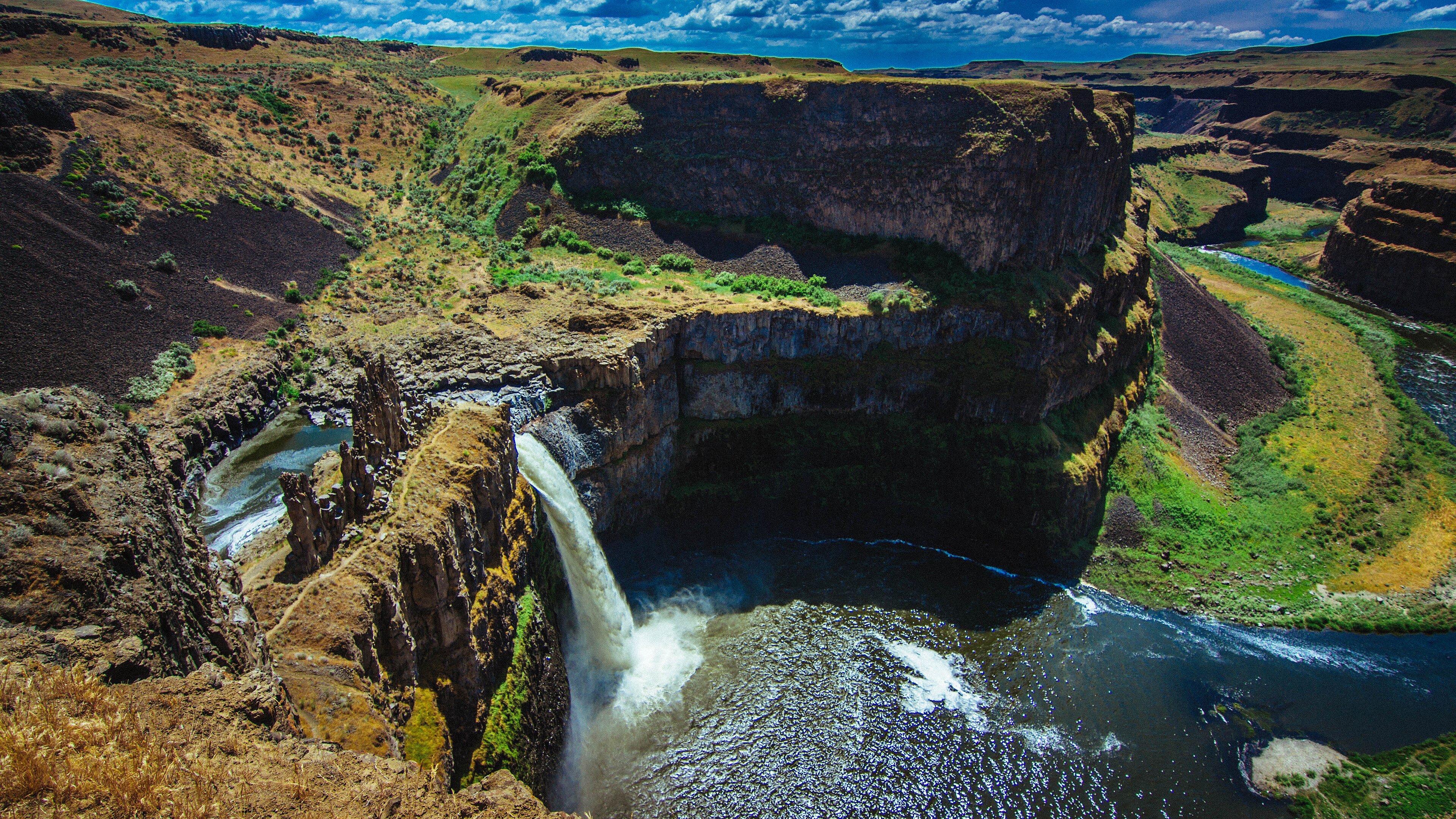

Almost everything the Missoula Floods carved in eastern Washington is dry. Dry Falls is the famous example, a cataract three and a half miles wide with nothing going over it.
Palouse Falls is the one that still runs.
The Palouse River drops 198 feet off a basalt lip into a circular plunge-pool amphitheater, then continues through a deep gorge to meet the Snake River a few miles downstream. It was designated Washington's official state waterfall in 2014, after a campaign by a group of schoolchildren.
It is also, quite obviously, far too small for the canyon it sits in, and that mismatch is the whole story.
A river in someone else's canyon
Stand at the overlook and look at the proportions. The falls is impressive. The gorge below it is enormous, sheer-walled and hundreds of feet deep, and the modern river runs along the bottom of it like a thread. That is because the Palouse River did not cut this canyon. The floods did.
Before the ice age the Palouse ran a different course to the Columbia, and when the Missoula Floods came through, the water overtopped the divide, carved a new channel straight south to the Snake, and left the river permanently redirected into a canyon vastly larger than it could ever have made itself. Geologists call this an underfit stream, a modern river occupying a valley cut by something far bigger, and Palouse Falls is one of the clearest examples anywhere.
The falls itself sits at a recessional headwall, the point where the flood cataract had eroded back upstream when the water stopped. It froze in place mid-retreat.
What you can walk
Less than you might expect, and this needs saying clearly before you drive three hours. This is a small park built around a viewpoint, and the main overlook area is short, paved in part, and gives you the falls, the amphitheater and the gorge, with upper viewpoints along the rim reached on informal paths. The Fryxell Overlook on the upper rim is the classic composed view, and walking upstream along the rim gives you the upper falls and the canyon in both directions.
The trails down to the river and to the base of the falls are closed, and have been for years. The routes descend loose, exposed, crumbling basalt, people have died on them, and the park has fenced and signed the closures. Do not go down: the rock here is fractured columnar basalt with no reliable holds, the exposure is immediate, and rescue is a long way away.
That closure is the specific reason to check an authoritative source rather than a trail app before driving out here, because those routes still appear in older guidebooks and on user-generated maps, drawn by people who walked them before the closure or in spite of it. A crowd-sourced line on a map is a record that somebody went that way, not that it is open or survivable. Guidepole Hike carries official closure status against the route, which at a park where the closed trail is the one people die on is the difference that matters.
One piece of trivia belongs here, because it is the most common question about the place. In 2009 the kayaker Tyler Bradt ran Palouse Falls, setting a world record for the highest waterfall descended in a kayak at 186 feet as measured for the record, and he survived, breaking a paddle and a wrist. The park does not encourage this and running the falls is not permitted, but looking at the drop with that in mind gives you a useful sense of the scale.
The seasons change it completely
Spring is the reason to come, because from March through May the Palouse runs high with snowmelt and runoff from the wheat country upstream and the falls is at full volume, with April the peak. Late spring also brings wildflowers to the sagebrush and, in a good year, green on the canyon walls.
Summer reduces the river substantially and bakes the park, with temperatures over 100°F normal, no shade whatsoever, and the falls a fraction of its spring self. Autumn is pleasant walking with low water, and winter is cold, clear, quiet and occasionally spectacular when ice forms on the amphitheater walls.
The practical rule is simple: come in April if the waterfall is the point.
Why the basalt looks like that
The walls around the falls are columnar basalt, and the hexagonal columns are worth understanding because you will see them across the entire region. When a thick lava flow cools it contracts, contraction cracks propagate down from the cooling surface, and the geometry that most efficiently relieves the stress is a hexagonal network, the same reason mud cracks and honeycomb form hexagons. The result is a flow that splits into vertical columns, often several feet across and tens of feet long.
The Columbia River Basalt Group is the source. Between roughly 17 and 6 million years ago an extraordinary sequence of flood basalt eruptions covered much of eastern Washington and Oregon in lava, in some places to a depth of more than two miles, flow on top of flow. That stack is what the Missoula Floods later cut through, so the layered walls at Palouse Falls are individual lava flows, and you can count them.
The Palouse itself
The country you drive through to get here is worth a paragraph, because it is unlike anywhere else. The Palouse is a region of deep, rolling hills of loess, meaning wind-blown silt deposited over hundreds of thousands of years, in places over two hundred feet deep. It is some of the most productive dryland wheat country in the world, and the hills are shaped like dunes because in a sense they are.
In late spring it is intensely green and in late summer gold, and the photographs people take from Steptoe Butte an hour east are among the most recognizable landscape images in the Pacific Northwest. The floods scoured much of the loess away in the channel areas, which is exactly why the scablands look like bare rock and the Palouse looks like velvet, sometimes within a few miles of each other.
The Snake River below
The Palouse joins the Snake River a few miles downstream, and that confluence is worth knowing about because it explains the modern landscape. The lower Snake carries four dams built between the 1960s and 1970s, which converted the river into a chain of slackwater reservoirs and opened barge navigation as far inland as Lewiston, Idaho.
Those dams are the subject of one of the longest-running environmental arguments in the Pacific Northwest, because the lower Snake was historically among the most productive salmon and steelhead rivers on the continent and the runs have collapsed. The Palouse River itself is impounded near its mouth by the backwater from Lower Monumental Dam.
None of this is visible from the falls, but the water going over the lip ends up in a reservoir rather than a river within a few miles, and the argument over whether that should change is live.
Palouse Falls: Two Minute GeologyLyons Ferry and the archaeology
A short drive from the park, at the Snake confluence, is one of the more significant archaeological areas in the Northwest. The Marmes Rockshelter, excavated in the 1960s, produced human remains and artifacts dating back more than ten thousand years, making it at the time among the oldest documented human sites in North America.
The site was flooded in 1969 by the reservoir behind Lower Monumental Dam, despite a protective levee built specifically to save it, which failed. It is now underwater.
It is worth knowing while standing at the falls that people have been in this landscape since not long after the last flood came through it, and that the record of that was lost to the same era of dam building that reshaped the rivers.
The gear
Palouse Falls is a small park in a very empty place, and the gear list is a self-sufficiency list with a camera in it.
All your water, because there is essentially none here and the nearest services are a long way off in any direction.
A Discover Pass, required for the lot.
A wide-angle lens and a telephoto, which is a real recommendation rather than a photographer's flourish. The wide shot takes in the whole amphitheater and the telephoto isolates the falls against the basalt columns, and the two pictures are entirely different.
Sun protection, in a place with no shade at all.
Sturdy shoes, for basalt and for the rim, and a word on where not to walk: the deaths at this park have all been people who went beyond the fenced overlooks toward the rim or attempted the unofficial route to the bottom. There is no legal route down and the park is explicit about it.
Rattlesnake awareness, for the same coulee reasons as at Dry Falls.
And a full tank of fuel, since this is a remote corner of Washington and the distances between stations out here are the kind that catch visitors.
Getting the photograph
A large proportion of people who make this drive come for the picture, so it is worth being direct about how it works. The classic composition is from the upper rim looking down the canyon, with the falls on the left, the plunge pool center and the gorge running away to the right, and it is available within a few minutes of the parking lot.
Light is the problem. The falls faces roughly northeast, so it gets morning light and sits in shadow through the afternoon while the canyon rim above it stays bright, which is a very high contrast situation that defeats most cameras. Early morning is the answer for the falls itself, late evening works for the canyon and the basalt when the low sun rakes across the columns and shows their structure, and overcast is good here because it evens the contrast out.
Spring runoff puts mist in the amphitheater, which is the difference between a good photograph and a memorable one, and a polarizer cuts glare off wet rock and deepens the sky, which in a landscape this monochrome matters more than usual. Night is the underrated option, because eastern Washington has dark skies, the park is remote, and the Milky Way over the canyon in summer is a serious astrophotography subject.
Palouse Falls State ParkPractical notes, and staying nearby
A Discover Pass is required for parking, at $10 a day or $45 a year, covering state parks plus Department of Natural Resources and Fish and Wildlife land. It is remote, sitting between LaCrosse and Starbuck on gravel and secondary roads, roughly four hours from Seattle, two from Spokane and an hour and a half from the Tri-Cities. There is no water and minimal facilities, so bring everything, and signal is poor.
Dogs are welcome on an eight-foot leash, and the heat and cliff edges both deserve thought. Rattlesnakes are common, as are ticks. And the cliff edges are unfenced in places and the basalt breaks away, so keep back and keep children close, which is the single most important sentence in this article.
The park has a small primitive camping area with limited sites, no hookups and minimal facilities, first come first served in practice, and it fills on spring weekends when the falls are at peak. Otherwise, Lyons Ferry nearby offers a marina and boat access on the Snake, Dayton about an hour southeast is the pleasant option with a well-preserved main street and somewhere decent to eat, the Tri-Cities are ninety minutes west with full services, and Walla Walla is roughly ninety minutes southeast and has become a serious wine region, which is an unlikely but genuine reason to build a trip around this corner of the state.
Is it worth four hours from Seattle?
Honestly, as a single destination, probably not. As part of a loop through the scablands, absolutely.
Pair it with Dry Falls and the Grand Coulee, and the two together tell the whole flood story: one cataract abandoned, one still running, both far too large for the water that made them look small. Add Steptoe Butte for the Palouse hills and Lake Lenore Caves for the flood-eroded shelters, and you have an unusual weekend in a part of Washington that most of the state's own residents have never visited.
More flood country at Dry Falls. The wet side of the state is in hiking Seattle and Deception Pass, and the pass rules are in six states, six ways to charge you for a trailhead.
The other scabland park, telling the same flood story at a different scale, is in Dry Falls. The rail trail across this country is in the Palouse to Cascades Trail. The Discover Pass that covers the lot is in state park passes by state, and the contrast with the wet side of the state is in Larrabee and Chuckanut and hiking Seattle.
And a note on the official status, which is a small piece of Washington trivia worth knowing. Palouse Falls was designated the official state waterfall in 2014 after a campaign run by a class of fourth graders from Washtucna, the nearest town, who researched it, wrote the bill and testified for it in Olympia. The park is small, remote and underfunded, and the reason it has any statutory recognition at all is a school project that worked.