Fish
Fish Fire
Fire Hike
Hike Bird
Bird

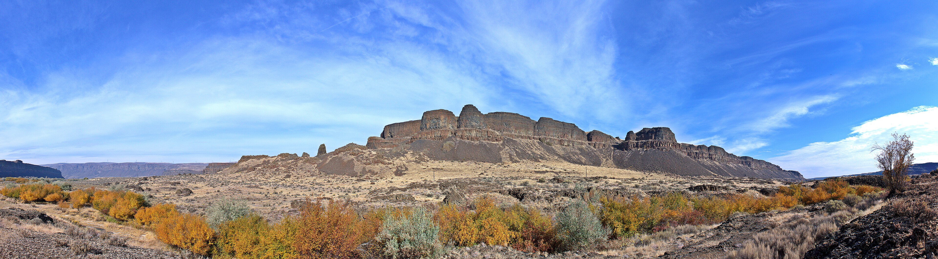

There is a viewpoint on Highway 17 in eastern Washington where you look out over a horseshoe-shaped cliff three and a half miles wide and about four hundred feet high, with a chain of small lakes at its foot and nothing whatsoever falling over it.
It is the largest known waterfall ever to have existed on Earth, and it has been dry for roughly thirteen thousand years.
By way of comparison: Niagara Falls is about a mile wide and 165 feet high.
What happened here
During the last glaciation, a lobe of the Cordilleran ice sheet pushed south into the Idaho panhandle and dammed the Clark Fork River. Behind the ice, water backed up into western Montana and formed Glacial Lake Missoula, which at its largest held something in the region of 500 cubic miles of water, comparable to Lake Ontario and Lake Erie combined.
Ice floats. Eventually the lake rose high enough to lift its own dam, and the dam failed catastrophically. The resulting flood tore west across eastern Washington, stripping soil, scouring bedrock, carving canyons in days rather than millennia, and pouring toward the Columbia, with peak discharge estimates running to figures that are difficult to hold in the head. A commonly cited comparison is roughly ten times the combined flow of all the rivers on Earth.
Then the ice advanced again, the lake refilled, and it happened again. The current understanding is that this cycle repeated dozens of times over a couple of thousand years. Dry Falls is where an enormous share of that water went over an edge.
The scablands, and a scientist nobody believed
The landscape the floods left is called the Channeled Scablands: a vast area of eastern Washington stripped down to bare basalt, cut by dry canyons called coulees, littered with giant gravel bars and boulders carried tens of miles.
The man who worked out what had made it was J Harlen Bretz, a geologist who in the 1920s proposed that the scablands were carved by a catastrophic flood. This was close to heresy, because geology at the time was committed to uniformitarianism, the principle that landscapes are shaped by ordinary processes acting slowly over immense time, and catastrophic explanations carried an unwelcome whiff of Biblical flood geology. Bretz was attacked for decades.
He was right. The source of the water, Glacial Lake Missoula, was identified by Joseph Pardee, and the evidence accumulated until it became undeniable, with Bretz receiving the Penrose Medal, geology's highest honor, in 1979 at the age of ninety-six. It is one of the better stories in the history of science, and you are standing in the evidence.
What to walk
The park is Sun Lakes-Dry Falls State Park, and the hiking is desert hiking: open, rocky, exposed and unlike anything on the wet side of the state.
The Dry Falls Visitor Center overlook requires no walking at all and gives you the whole cataract, so start there, because the scale is the point and it is easier to grasp from above. Umatilla Rock is the best walk in the park, a knife-edged basalt ridge standing in the middle of the old flood channel below the falls, a remnant the water split around rather than removing, with a trail running along and around it for roughly three to four miles depending on your route, the cliffs of Dry Falls on one side and the lakes on the other.
Beyond those, Monument Coulee and the trails around the Sun Lakes chain give flatter walking past water, Deep Lake sits at the bottom of a side coulee with sheer basalt walls and is worth the short drive, and Lake Lenore Caves a few miles south are shallow shelters eroded into the basalt by the floods and used by people afterward, reached on a short steep trail. Northrup Canyon, north of the park, holds the only natural forest in Grant County, a hanging valley the floods did not scour, and it is a strange thing to find here.
Reading the ground
Once you know what to look for, the whole landscape becomes legible, and this is the real reward of the place. The lakes at the base of Dry Falls are not ordinary lakes but plunge pools, sitting in holes drilled into bedrock by falling water. Potholes are rounded cavities in the basalt, scoured by boulders spun in place by the current, and some are several feet across.
Giant current ripples appear in some parts of the scablands, ripple marks like those on a sandy streambed except tens of feet high and hundreds of feet apart, hard to see from the ground and obvious from the air. Erratics are boulders of granite and other rock foreign to this basalt country, rafted in on icebergs and dropped where they melted.
Two more features explain the shape of the coulee itself. Recessional headwalls show where Dry Falls migrated upstream as it eroded, in the same way Niagara does but vastly faster. And hanging valleys are side canyons whose floors sit high above the main coulee, because the main channel was cut down faster than the tributaries could keep up.
What lives in a scabland
The floods stripped the soil, and what grows here now is a direct consequence of that. Shrub-steppe is the dominant community, with big sagebrush, rabbitbrush and bunchgrasses and bare ground between them, and it looks empty and is not: shrub-steppe is one of the most threatened habitats in Washington, because the parts with deep soil were plowed for wheat and the parts with irrigation became orchards, so what survives is largely the ground the floods scoured, which was never worth farming.
Biological soil crust fills the gaps between plants, a living skin of cyanobacteria, lichens and mosses that binds the surface, fixes nitrogen and holds moisture, and it takes decades to recover from a footprint, which is the practical reason to stay on trail here even where the ground looks like bare dirt. Balsamroot turns whole hillsides yellow in April, with lupine, phlox and bitterroot following.
For wildlife, bighorn sheep were reintroduced to the coulee walls and are occasionally visible on the cliffs, and birds are the surprise, because the lakes at the base of the cataract are on the Pacific Flyway and the combination of open water in a desert draws waterfowl in enormous numbers on migration, with golden eagles and prairie falcons nesting on the basalt. Rattlesnakes and scorpions are both present, and the marmots on the talus are yellow-bellied rather than the Olympic species from the wet side.
The Grand Coulee, and where the river went
Dry Falls sits inside a much larger feature, and understanding the relationship makes the whole area legible. The Grand Coulee is a canyon roughly fifty miles long, cut by the floods and by the diverted Columbia River, because during the glacial period the ice sheet dammed the Columbia's normal course, forcing the river south across the plateau where it and the floods together carved this enormous channel.
When the ice retreated the Columbia returned to its old bed and the coulee was abandoned, leaving a dry canyon the size of a major river valley with only lakes in the bottom of it. Dry Falls sits at the point where the Upper Coulee steps down into the Lower Coulee, which makes it the knickpoint of the whole system.
Grand Coulee Dam, half an hour north, now pumps Columbia water back up into the coulee to feed the Columbia Basin Project irrigation scheme, which means water is once again flowing through a channel the ice age created and then abandoned, and Banks Lake, the reservoir filling the Upper Coulee, exists because of that. So the modern landscape has a river running through it again, by pump, for agriculture, roughly thirteen thousand years after the last flood.
Dry Falls: Roadside GeologyThe desert, which is a real desert
This is not a technicality. The Columbia Basin here sits in the rain shadow of the Cascades and receives well under ten inches of precipitation a year. Summer temperatures routinely exceed 100°F, there is essentially no shade anywhere in the park, and the basalt radiates heat, which makes heat the genuine hazard here rather than terrain.
Spring is the season, because March through May brings wildflowers to the sagebrush steppe, tolerable temperatures and the best light on the cliffs, and autumn is the other good window from September into October. Winter is cold, often clear and very quiet, with the added benefit that the low sun rakes across the cataract and shows its structure better than summer light does.
Rattlesnakes are common from spring through autumn, as are ticks. And carry all your water, because the lakes are not a supply.
The gear
Dry Falls is a desert park in the channeled scablands, and everything here is about heat, rock and the absence of shade.
Far more water than you think, which is the first and most important item. There is no shade anywhere in this landscape, summer temperatures run past a hundred, and the trails down into the coulee are exposed in both directions.
A sun hat and high-SPF sunscreen, for the same reason.
Sturdy shoes for broken basalt, because the scabland surface is angular fractured rock rather than soil, and it is hard on thin soles and on ankles.
A Discover Pass, which the state parks here require.
Awareness of rattlesnakes, which are present in the coulee and on the talus, and which are a reason to watch where you put hands and feet rather than a reason not to come.
Binoculars, for the lakes below, which hold waterfowl and which sit in a landscape that otherwise looks lifeless.
And a wind layer, because the scablands funnel wind and a hot day with a thirty-mile-an-hour wind on the rim is still a day you want a shell for.
Making a loop of it
The scablands reward a route rather than a destination, and the good stuff is spread across a couple of hours of driving. Grand Coulee Dam is worth seeing for scale alone, being one of the largest concrete structures ever built and sitting in the channel the floods cut, and Steamboat Rock State Park rises out of Banks Lake in the Upper Coulee as a flat-topped basalt butte with a steep trail to the top and a wide summit plateau, which makes it the best hike in the coulee after Umatilla Rock.
Lake Lenore Caves and Summer Falls fill in the Lower Coulee, Frenchman Coulee near Vantage has spectacular columnar basalt and is a well-known climbing area, and Wanapum and Ginkgo Petrified Forest, also near Vantage, preserve trees buried by the lava flows long before the floods arrived. Palouse Falls is two hours southeast and completes the story with the one cataract still running.
A two-day loop through those takes in flood geology, flood basalt, a dam and a working irrigation project, which is most of what makes eastern Washington what it is. It also crosses a remarkable number of managers in a short distance, running from state park to Bureau of Reclamation ground around the dam and Banks Lake to Fish and Wildlife land to BLM, and the boundaries out here are as invisible as the terrain is open. Guidepole Hike carries the managing agency and its pass requirement under each site, which across a scabland loop like this saves working out four separate answers to the same question.
A Guide to Sun Lakes Dry Falls State ParkPractical notes
A Discover Pass is required for parking, at $10 a day or $45 a year, and it also covers Department of Natural Resources and Fish and Wildlife land statewide, which is useful out here. Camping is available in the park and books up to nine months ahead, which is Washington's window.
Dogs are welcome on an eight-foot leash, and the heat is a real consideration for them here. It is about three hours from Seattle across Snoqualmie Pass and roughly two from Spokane. And the visitor center has seasonal hours and gives the best short explanation of the geology you will get anywhere.
Why come
Because almost nowhere else lets you stand in a landscape and see the evidence of a single event this large.
Most geology asks you to imagine millions of years. Dry Falls asks you to imagine a week. The canyon you are standing in was cut in days, by water moving fast enough to roll house-sized boulders, from a lake that no longer exists, dammed by ice that no longer exists.
And the man who figured it out spent forty years being told he was wrong.
Washington's wet side is covered in hiking Seattle and Deception Pass. The other great scabland waterfall is Palouse Falls, the state's pass system is in six states, six ways to charge you for a trailhead, and what a Discover Pass covers beyond the park boundary is in state park, national forest, or wilderness.
The other eastern Washington scabland park is in Palouse Falls, which is the same flood story at a different point on the map. The rail trail that crosses this country is in the Palouse to Cascades Trail. The wet side of the state is in North Cascades day hikes and hiking Seattle, and the pass that covers these lots is in state park passes by state.