Fish
Fish Fire
Fire Hike
Hike Bird
Bird

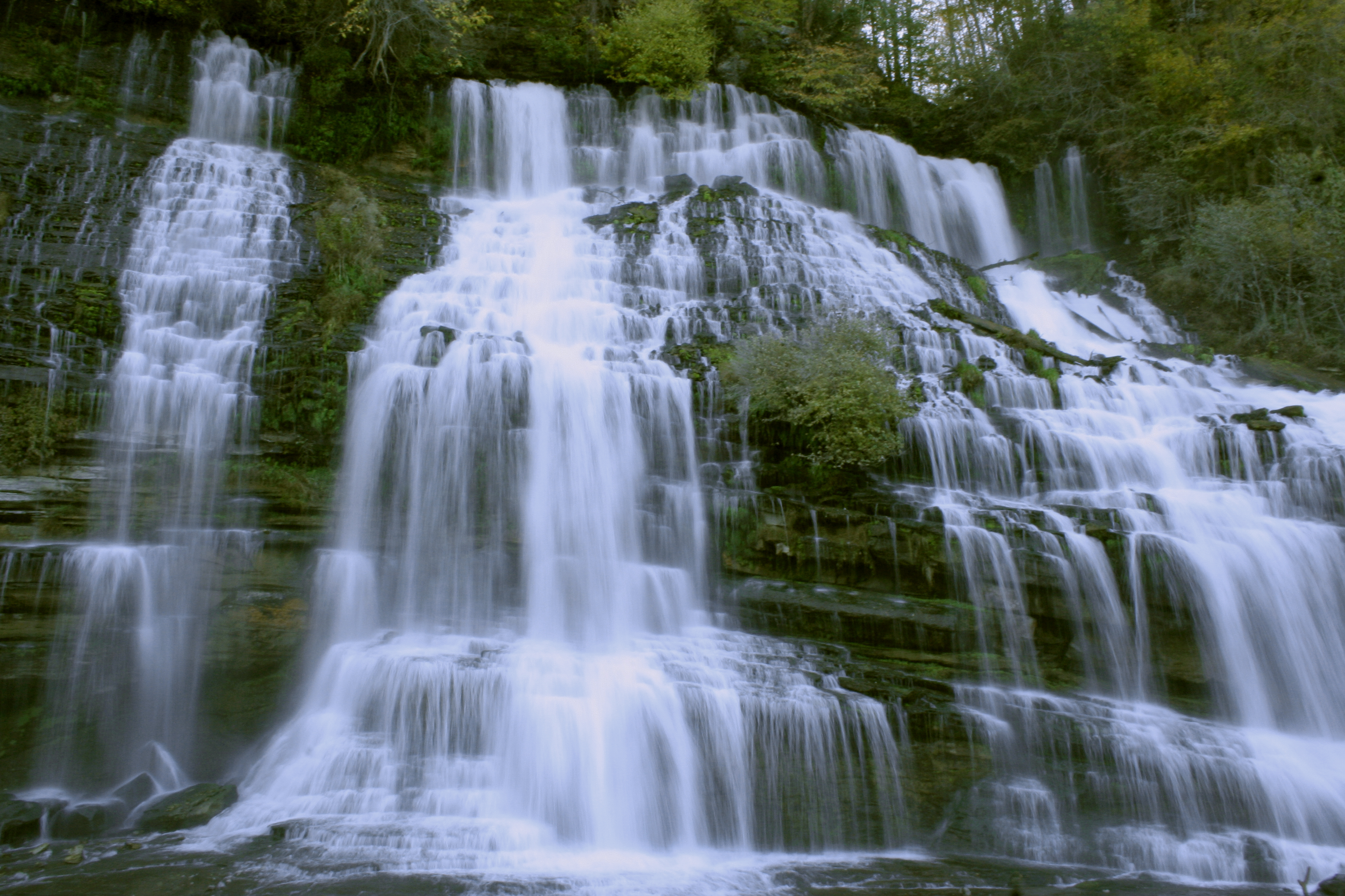

Twin Falls at Rock Island is one of the strangest waterfalls in the eastern United States, and the reason is that nobody designed it.
It emerges directly from the face of a limestone cliff, a broad curtain of water roughly eighty feet tall and about twice that wide, with no stream above it. Water appears out of the rock.
It has only existed since around 1917.
What happened
The Great Falls Dam was built on the Caney Fork in the 1910s, and the reservoir it raised sits on karst limestone: rock riddled with fractures, conduits and cave passages dissolved out over geological time. Water under pressure in a reservoir does not respect the engineers' intentions, so it found the fractures, traveled underground beneath the ridge, and came out the other side, pouring from the cliff wall above the Caney Fork gorge.
So Twin Falls is leakage: a significant, permanent, unstoppable leak from a hydroelectric impoundment, which has become the most photographed feature in the park and one of the best-known waterfalls in Tennessee. The volume varies with the reservoir level rather than directly with rainfall, which makes it behave unlike any other waterfall in the region, and it can run hard in a dry spell.
The gorge below
Beneath the falls the Caney Fork runs through a limestone gorge with bluffs, boulders and a series of pools and cascades that have made this one of the most popular swimming and paddling spots in Middle Tennessee.
The rock here is worth looking at, because the gorge exposes bedded limestone with visible solution features and the whole area is textbook karst: caves, sinkholes, springs, and a river that behaves differently above and below ground. The Blue Hole and the cascades along the river below the dam are where most of the summer crowd goes.
The danger nobody expects
This needs stating plainly, because it is specific to Rock Island and it has killed people. The Caney Fork below the dam can rise without warning when water is released, because the gorge sits downstream of an active hydroelectric facility and generation schedules are not published for the convenience of swimmers. A pleasant set of pools can become a fast, deep, cold river in minutes.
Warning sirens and signs exist and they are not decorative, so if you hear a horn or see the water rising, get out and get high immediately. Several drownings have occurred here, because the combination of strong current, cold water from the bottom of a reservoir, undercut rock, and a crowd of swimmers who have no reason to expect a change is dangerous.
The park closes river access when conditions warrant, and those closures are worth obeying. They are also worth checking before you drive out, because this is a closure driven by a utility's generation schedule rather than by weather or season, which makes it the least predictable kind: the sky tells you nothing and neither does the forecast. Guidepole Hike carries current access status against the specific river sections, which at a park where the hazard is upstream and invisible is more use than a seasonal rule.
There is a social dimension worth naming too. Rock Island occupies an unusual position in Middle Tennessee, being simultaneously a state park with rules and a place a great many people have been swimming since childhood, and that tension shows. Cliff jumping is prohibited and happens. River access closes and people go anyway. The pools below the dam draw large summer crowds who are not thinking about generation schedules. The presence of a crowd in the water is not evidence that the water is safe; it is evidence that the water was safe when they got in. If you are visiting with children, or if you are new here, treat the posted rules as the information rather than the local practice.
The mill, and the town that was going to happen
The ruin beside the river is worth more than a glance. The Great Falls Cotton Mill was built in the 1890s, a three-story stone and brick structure powered by the falls of the Caney Fork, and it was meant to anchor an industrial town at Rock Island, because water power was the whole premise: the river dropped hard here, and that drop was the reason to build.
It did not work out. The mill operated for a relatively short period, was wrecked by the great flood of 1902 that swept away its wheelhouse, and was never rebuilt, and the shell has been standing beside the river for well over a century. Then the dam arrived in the 1910s and rearranged the hydrology completely, drowning the falls that the mill had been built to use and, as a side effect, creating Twin Falls out of the leaks.
So within a few hundred yards you have a nineteenth-century industrial ruin built to exploit a waterfall that no longer exists, and a twentieth-century waterfall that exists only because of the dam that destroyed the first one. It is a remarkably compressed piece of industrial history, and the old spring house and the remains of the powerhouse fill in the rest.
Karst, and why this landscape leaks
The reason Twin Falls exists is worth understanding properly, because it explains a great deal of Middle Tennessee. Karst forms where slightly acidic groundwater dissolves limestone along fractures and bedding planes over very long periods, and the result is not a solid rock mass with a few cracks but a rock mass threaded with conduits, some of them large enough to walk through.
Middle Tennessee sits on some of the most extensively karsted limestone in North America, and the consequences are everywhere: caves in the thousands, sinkholes that swallow surface streams, springs that produce rivers from nothing, and disappearing creeks that run underground for miles. When the Great Falls impoundment raised a head of water over that rock, the water did what water does and found the conduits.
Engineers have understood this since long before Rock Island, and building large reservoirs on karst remains one of the hard problems in dam construction, because grouting programs can reduce leakage and rarely stop it. The practical version for a visitor is that the ground here is not solid, the springs and seeps along the gorge are the same system at smaller scale, and the caves in the surrounding country are part of the same plumbing.
The trails
The park is about 880 acres, and the walking is short, varied and mostly close to water. The Twin Falls overlook is a short walk from parking and gives you the falls from across the gorge, which is the best view of them. The Downstream Trail runs along the Caney Fork below the dam through the gorge, with access to the pools and views of the cliff walls, and it is the busiest.
The Upstream Trail follows the impoundment side, quieter and gentler, the Eagle Trail connects across the park with some elevation, and the historic buildings near the dam are worth the short walk. None of this is long, and a comprehensive day here is a handful of miles.
Rock Island State Park Visitor GuidePaddling, and why people come with boats
The Caney Fork gorge below Rock Island is one of the better-known whitewater stretches in Middle Tennessee, and if you visit on a generation day you will see it being used. The combination of a dam-controlled release, a bedrock gorge and a short accessible run makes for a reliable playboating spot, with features that turn on at predictable flows rather than depending on rain, so kayakers watch the generation schedule the way climbers watch weather.
The same water that makes the gorge good for boats is what makes it dangerous for swimmers. It is the identical phenomenon read two different ways, and the difference is that one group is watching the schedule and wearing helmets. Below the gorge, the Caney Fork slows into the Center Hill impoundment and becomes flatwater, which is where most of the canoe and paddleboard traffic goes.
The gear
Rock Island is a park where the water is controlled by a dam, and the most important item on this list is an awareness rather than an object.
Awareness of the warning horns, which is the safety issue at this park and the reason people have died here. The Great Falls plant releases water without much warning, the horns sound before it happens, and the gorge below fills quickly. If you hear them, get out of the riverbed.
Water shoes with real grip, since the rock in the gorge is smooth, wet and slick with algae, and the interesting parts of this park are all in or beside the water.
A dry bag.
Trekking poles, for the descent into the gorge and back out.
Sun protection, because the gorge below the falls is open rock with no canopy.
Tick and chigger repellent, for the trails on the bluffs.
And a telephoto lens, if you are photographing, because the best angle on the falls coming out of the bluff face is from across the water rather than from beside them.
The birds and the bluffs
The gorge walls are more than scenery. Cliff swallows nest in colonies under the rock overhangs and on the dam structure, and on a summer evening the air over the river is full of them. Black vultures and turkey vultures use the gorge thermals and the bluff ledges are roosts, great blue herons work the shallows below the falls, and the tailwater holds fish year-round because of the cold releases. Bald eagles are increasingly common on the Caney Fork and around Center Hill Lake, a recovery that has happened within the last few decades.
The limestone bluffs themselves support a specialized flora in the crevices and on the ledges, plants that tolerate thin soil, high pH and periodic drought, which is easy to walk past as bare rock and is not.
Rock Island State Park: Tennessee's Most Unique WaterfallThe other end of the park
The upstream side, above the dam on the Collins and Caney Fork arms, is the half most visitors skip entirely. It is flatter, quieter and better for a family walk, with lake access, the campground and the cabins, and on a busy summer Saturday when the gorge below the dam is heaving, this side is often close to empty.
It is also where the Collins River comes in, and the confluence area holds good birding in the shoulder seasons.
Season, practical notes, and what to do
Summer is the busy season because the swimming is the draw and the park is crowded on hot weekends. Spring brings the highest and most dangerous water and the best waterfall volume, autumn is the best hiking with plateau color and thin crowds, and winter is quiet and excellent, with bare trees exposing the gorge structure and the falls. The key variable at Rock Island is not the season but whether the dam is generating, which is not predictable from the weather.
There is no entrance fee, as has long been the case across Tennessee state parks, though parking and activity charges are a separate question and worth confirming with the park before you go. Camping is available along with cabins and books six months ahead, dogs are welcome on leash, and the park is roughly an hour and a half from Nashville and about the same from Chattanooga. Parking at the Twin Falls overlook is small and fills fast in summer. There are no lifeguards anywhere and the river is not a swimming pool. Copperheads, ticks and chiggers are present as everywhere on the plateau. And cliff jumping happens here despite being prohibited, and it is a regular source of serious injury.
For the visit: an hour gets you the Twin Falls overlook and the historic mill. A half day gets the Downstream Trail through the gorge, with the pools if the river is low and the dam is quiet. And a full day adds the Upstream and Eagle trails, plus a twenty-mile drive to Burgess Falls.
Take a moment at the overlook to appreciate what you are looking at: a hundred-year-old engineering mistake that turned into one of the finest waterfalls in the state, and which no amount of grouting has ever managed to stop.
The rest of the plateau's water is in Burgess Falls, Cummins Falls, Fall Creek Falls and Virgin Falls. Fee rules across the region are in six states, six systems, and the Caney Fork below the dam is a well-known tailwater fishery, covered in fly fishing the Caney Fork.
The other Caney Fork country parks are in Burgess Falls and Cummins Falls, and the largest plateau park is in Fall Creek Falls. The remote gorge version is in Virgin Falls and Savage Gulf. The dam-controlled river pattern here works much like the one described in Norris Dam State Park.
A word on what makes the main falls strange, because it is not a normal waterfall. Twin Falls does not come over a lip: it emerges from the face of the bluff itself. When the Great Falls dam was built in 1916 the impoundment forced water into the limestone, and it found a path through the rock and came out the other side as a wall of springs eighty feet high. It is an accident of engineering that has been running for over a century, which is why it looks like nothing else in the state.