Fish
Fish Fire
Fire Hike
Hike Bird
Bird

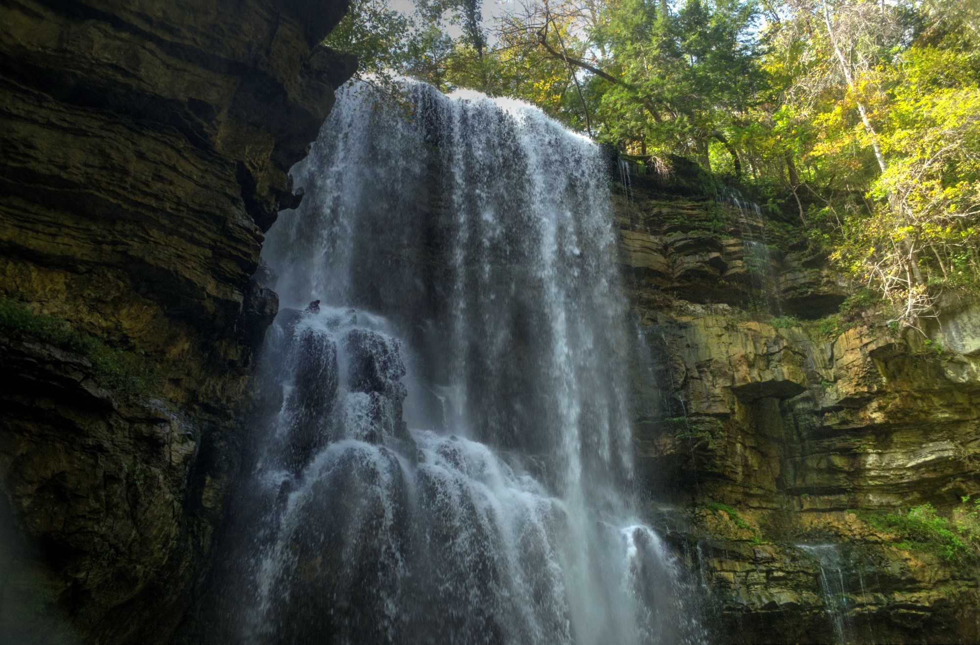

Almost every waterfall you will ever visit is a river doing something dramatic on its way somewhere. Virgin Falls is not that.
An underground stream emerges from a cave mouth partway up a cliff, falls 110 feet into the bottom of a sinkhole, and then disappears into a second cave at the base. It does not run out the other side. It does not join the Caney Fork on the surface. The water arrives from the rock and returns to it.
Getting there is a nine-mile round trip with roughly 900 feet of elevation change on rocky, root-tangled trail, and it is one of the harder day hikes in Tennessee.
The karst, which is the whole story
The western Cumberland Plateau is karst country, where limestone beneath the sandstone cap has been dissolving along fractures for millions of years, producing caves, sinkholes, springs, disappearing streams and underground rivers.
On this part of the plateau a great deal of the drainage happens below the surface. Water sinks through the cap, runs through conduits in the limestone, and re-emerges wherever a passage intersects a valley wall. Virgin Falls is what happens when a conduit opens partway up a cliff above a sinkhole that has another conduit at the bottom of it, so the stream is visible for exactly the length of its fall.
Once you understand this, the rest of the trail makes sense too, because the same thing is happening repeatedly at smaller scale along the way.
The other waterfalls on the route
This is why the trail is worth the nine miles rather than being a long walk to one thing. Big Laurel Falls drops into a cave and vanishes, on the same principle as Virgin Falls but smaller and reached earlier on the trail, and you can walk behind it into the cave mouth. Sheep Cave has a stream emerging from a cave and falling into a sink, while Big Branch Falls is a more conventional cascade on the way in.
Martha's Pretty Point is a bluff overlook out over the Caney Fork gorge and the best long view on the route, a short spur off the main loop that it would be a mistake to skip.
So the day gives you three disappearing streams, a conventional waterfall, and a gorge overlook.
What the trail is like
Harder than the numbers suggest, and this catches people out badly. Nine miles round trip on the standard loop with around 900 feet of cumulative change sounds moderate, and the tread is the problem: rock, roots, loose sandstone blocks and repeated short steep sections, so mileage runs slow here and most people take substantially longer than they plan for.
Creek crossings are unbridged and can be difficult after rain, and in high water they are the reason to turn around. The descent into the sink at Virgin Falls is steep, and the climb back out comes at the far end of the day when you have already walked four miles in. Water is available along the route but must be treated. Budget six to eight hours, not four.
A natural area inside a new state park
This distinction matters here more than usual. Virgin Falls is a State Natural Area, folded in May 2025 into the new Scott's Gulf Wilderness State Park, Tennessee's 60th, which consolidated the former Virgin Falls and Lost Creek natural areas. The designation and the management behind it carry over: minimal facilities, a small gravel trailhead, no visitor center, and a priority of protecting the karst system rather than accommodating visitors.
Backcountry camping is permitted at designated sites and requires a permit worth arranging in advance, and this is one of the few places in Middle Tennessee where you can legally backpack, which makes it the best overnight on the plateau. Stay out of the caves, because the mouths are tempting and the passages beyond them are not casual terrain. And stay on the trail, because karst ground is undercut in ways you cannot see from above.
The designation itself is explained in natural area, scenic trail, reserve.
Bats, caves, and why the rules are strict
The caves here are not scenery, they are habitat, and it is habitat in crisis. White-nose syndrome is a fungal disease that arrived in North America around 2006 and has killed bats in the millions, with several species declining by more than ninety percent across their range. The fungus grows on hibernating bats in cold, humid caves, rouses them repeatedly through winter, and they starve.
The Cumberland Plateau's caves are significant hibernacula, and Tennessee holds some of the most important remaining populations. Human visitors matter for two reasons: disturbing hibernating bats costs them energy they cannot spare, and the fungus travels on gear and clothing, which is why cave closures and decontamination protocols exist across the region.
That is the real reason to stay out of the cave mouths on this trail, beyond the obvious physical risk. It is also why a State Natural Area designation here means what it means, because the priority is the system and visitors are accommodated around it.
What the forest is doing
The walk in passes through the same mixed mesophytic forest that covers this whole plateau, which is among the most botanically diverse temperate forest on earth, with no single dominant canopy species.
What makes the Virgin Falls route unusual is how much vertical variation it packs in. You start on a dry plateau top of oak and pine, drop through progressively cooler and damper slopes, and reach a gorge bottom of hemlock, yellow birch, ferns and moss that feels several hundred miles further north than it is.
The sinkholes and cave mouths create their own microclimates, because cold air drains into a sink and pools there, so the vegetation immediately around a cave entrance is often noticeably different from the forest twenty yards away. These are sometimes called algific slopes, and they can support relict plant communities left over from cooler periods. Hemlock woolly adelgid has hit this area as it has hit the whole region, and the dead hemlocks in the gorge are its work, which matters more than it might sound because hemlock shade is what kept these stream corridors cool. Spring wildflowers on the descent are excellent in April.
The Virgin Falls TrailHow the land was saved
The reason there is a nine-mile trail through this gorge rather than a subdivision is a long conservation effort that is worth knowing about. Scott's Gulf, a large gorge of the Caney Fork on the plateau's western escarpment, was privately held timber and hunting land for most of the twentieth century, and Virgin Falls itself was known locally, reached by informal permission, with no protection at all.
Protection came in stages. Bowater, a paper company, held much of the surrounding land and designated Virgin Falls as a pocket wilderness open to the public, which is how a generation of Tennessee hikers first got there, and corporate pocket wilderness areas were a genuine phenomenon in the region with several of today's protected sites starting that way. In the 1990s Bridgestone Firestone donated roughly 10,000 acres of Scott's Gulf to the state, creating the Bridgestone Firestone Centennial Wilderness, one of the largest single conservation donations in Tennessee history. The state designated Virgin Falls a State Natural Area, and land trusts including TennGreen have continued adding parcels since.
The result is a large protected block assembled from corporate donation, state purchase and private philanthropy over about forty years. None of it was inevitable, and the gorge came close to being logged out more than once.
It also explains the patchwork of rules, which is the practical consequence for anyone walking here. Within a few miles you cross natural area, wilderness and wildlife management area designations, each with its own permissions, and hunting is permitted in season on the adjoining wildlife management area while the natural area itself does not allow it. Nothing on the ground marks where one becomes the other, which is the argument for checking the Tennessee Wildlife Resources Agency season dates before walking here in autumn rather than working it out from signage that does not exist. Guidepole Hike carries the designation and its rules under the trail, which on a protected block assembled from four decades of separate acquisitions is the layer the trailhead kiosk does not show you.
The gear
Virgin Falls is nine miles round trip with repeated steep descents into and out of a gorge, and it is consistently underestimated.
Boots with ankle support, because the tread is rock, root and side-hill for most of its length and the descents are steep enough to roll an ankle on.
A water filter, since the route crosses several creeks and carrying nine miles of water in plateau humidity is more weight than it needs to be.
Trekking poles, which do more work here than on almost any other trail in this library. The trail drops and climbs repeatedly rather than once, and the cumulative descent is what people feel the next day.
A headlamp, because a great many people misjudge this hike and finish the last climb in the dark.
A backcountry permit if you are staying over, which the state requires for the designated sites and which is booked in advance.
Tick and chigger repellent, for the plateau summer.
And an early start, which is the practical answer to all of the above. This is a nine-mile day in humid country with real elevation change, and the people who leave the trailhead at nine in the morning have a much better time than the ones who leave at noon.
Season and conditions
Winter and early spring give the best water and the clearest views through bare trees, and the crossings are hardest then. Late spring is the balance point, with good flow, wildflowers and passable creeks. Summer is hot and humid and the falls diminish, which makes the trail unpleasant in July, while autumn is superb walking with lower water.
After heavy rain, the creek crossings are the deciding factor rather than the falls.
Backpacking Virgin FallsIf you only have half a day
The full loop is nine miles and not everybody has the time or the legs for it, so it is worth knowing what a shorter version gets you. Big Laurel Falls is roughly two miles in and is the single best short objective on the trail, because it demonstrates the whole disappearing-stream phenomenon at a manageable scale and you can stand in the cave mouth behind it.
Turning around there makes a four-mile round trip on the rougher part of the tread, which is an honest half day and still shows you the thing that makes this place unusual. Martha's Pretty Point can be reached on a shorter out-and-back if the gorge view is what you want.
What you cannot sensibly do is a quick look at Virgin Falls itself, because it is four miles in, over rough ground, with a steep drop into the sink at the end.
Practical notes, and where it sits
There is no fee, as everywhere in the Tennessee system. The trailhead is on a gravel road reached from Highway 70 east of Sparta and it is a long way from anything, parking is limited and fills on good weekends, and signal is gone from the trailhead onward. Dogs are permitted on leash, though nine rocky miles with unbridged crossings is a serious outing for a dog. Start early, because people finish this trail in the dark more often than they should. And copperheads and timber rattlesnakes are present, plus ticks and chiggers in season.
If you have done the easy plateau waterfalls and want the real thing, this is it. Burgess Falls is four waterfalls in under a mile, Cummins Falls is a permit and a river walk, and Fall Creek Falls is a park with a lodge and a golf course. Virgin Falls is nine miles of rough trail to a waterfall that arrives from a cave and leaves through another one, in a natural area that has deliberately not been developed.
It is the best hard day hike in Middle Tennessee, and the geology is more interesting than the waterfall, which is saying something about a 110-foot drop.
More plateau water at Burgess Falls, Cummins Falls, Rock Island and Fall Creek Falls. The escarpment's long route is the Cumberland Trail, and the wilder gorge system south of here is Savage Gulf.
The neighboring plateau parks are in Fall Creek Falls, Burgess Falls and Cummins Falls. The largest gorge system on the plateau is in Savage Gulf, and the long trail through this country is in the Cumberland Trail. The designation that protected this land is explained in state natural areas explained.
A note on what the falls does, because it is the reason for the name and it is unusual. Virgin Falls is fed by an underground stream that emerges from a cave, drops one hundred and ten feet, and then disappears into another cave at the bottom. The water arrives from nowhere visible and leaves the same way. On the plateau this is not as rare as it sounds, since the whole landscape is karst limestone riddled with conduits, but nowhere else does it happen at that scale in front of you.