Fish
Fish Fire
Fire Hike
Hike Bird
Bird


On September 18, 2024, the US Board on Geographic Names voted to stop calling this mountain Clingmans Dome.
It is Kuwohi now, pronounced koo-WHOA-hee, which is what the Cherokee have always called it. The name means mulberry place. The proposal came from the Eastern Band of Cherokee Indians, driven by two of its members, Lavita Hill and Mary Crowe, and it restored a name the mountain carried long before an 1859 survey attached the name of Thomas Lanier Clingman to it.
That matters here more than it would on most peaks, because Kuwohi is a sacred place in Cherokee tradition and the highest point within their traditional homeland. If you write it or say it, use Kuwohi. Signage and maps are still catching up, so plenty of both still read Clingmans Dome.
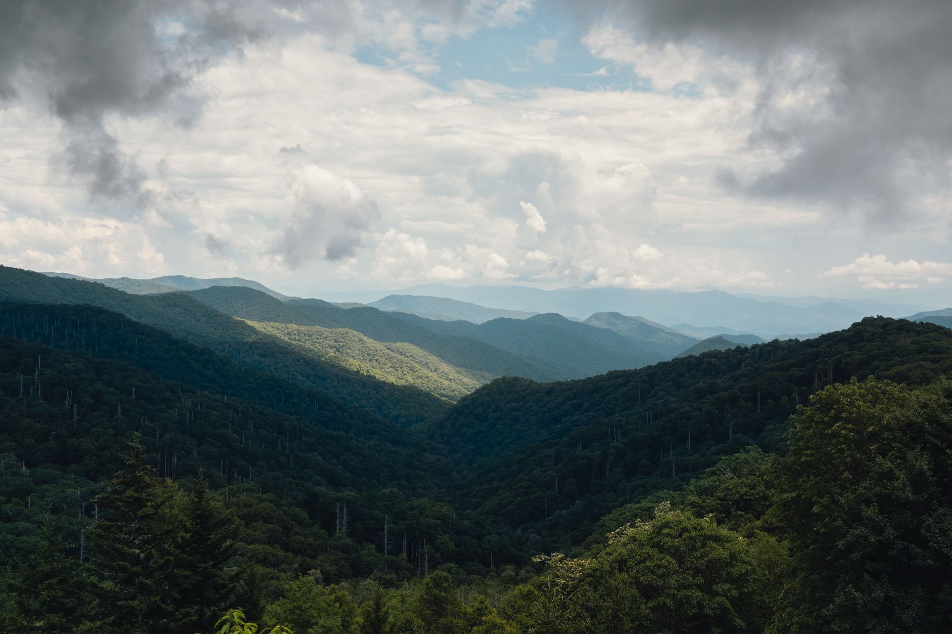
What you are visiting is 6,643 feet of Southern Appalachian spruce-fir forest, the highest ground in Tennessee, the third-highest summit east of the Mississippi, and the single highest point on the entire 2,190-mile Appalachian Trail.
The shortest walk to a big summit anywhere
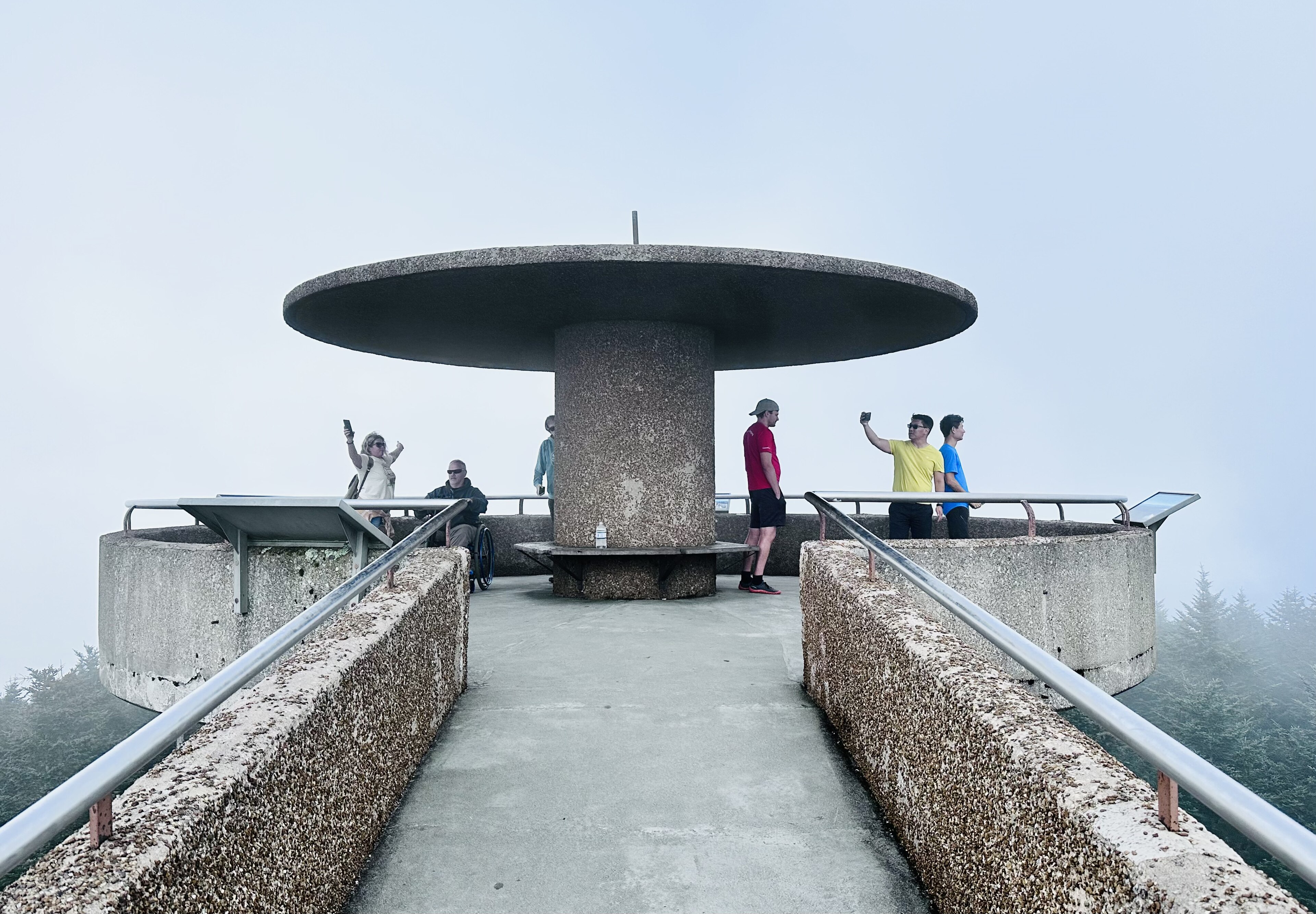
Here is the thing that surprises people: you do not hike Kuwohi so much as walk up a ramp. From the Forney Ridge parking area a paved half-mile trail climbs the 330 feet to the summit, and at the top a concrete observation tower built in 1959 rises 45 feet on a spiral ramp at a 12 percent grade to a 28-foot circular platform with a 360-degree view.
Half a mile and 330 feet is nothing in mileage terms. It is not nothing in effort terms, because the pavement is steep, it is continuous, and it starts above 6,300 feet where the air is thinner than most visitors are used to. People in flip-flops stop repeatedly on the way up, and the ramp adds another lap of climbing at the end. Call it 45 minutes round trip at a relaxed pace, more if you linger at the top, which you should.
The road is the constraint
Kuwohi Road runs seven miles up from Newfound Gap Road, and it is open only from April 1 through November 30. Outside that window there is no driving to the parking area at all. The mountain does not close, but reaching it becomes a real hike, because the standard winter approach is the Appalachian Trail from Newfound Gap, which is roughly eight miles round trip along the crest, frequently in snow and rime ice, and a completely different undertaking from the paved half-mile.
That contrast is worth holding on to, because the same summit is a family stroll in July and a serious winter ridge walk in January, and nothing about the name or the elevation tells you which one you are signing up for. It is entirely a function of one gate seven miles below. Guidepole Hike carries road status against the trailhead alongside the route, which here decides not just whether you can go but what kind of trip it is.
While the road is open you also need a Park It Forward parking tag to park anywhere in the park for more than 15 minutes, at $5 for a day, $15 for a week or $40 for the year at the time of writing, per vehicle regardless of occupancy, and worth confirming with the park because the tag is new enough to still be settling. This is separate from any entrance fee, because the Smokies famously charge none.
Kuwohi Walking Tour and What to ExpectExpect fog, and plan for it
Kuwohi is in cloud a great deal of the time, and the tower is regularly socked in to the point where the view from the platform is the platform. That is not bad luck, it is climate, because this is a temperate rainforest summit that receives enormous annual precipitation and the Smokies are named for exactly this. On a clear day visibility from the tower runs from 20 to 100 miles depending on conditions, and on a bad day it runs about 20 feet.
The practical response is to go early. Mornings, particularly in autumn, are meaningfully more likely to be clear than afternoons, and afternoon cloud build-up is the norm in summer. If you arrive to a white-out, the drive back down Kuwohi Road frequently drops below the cloud deck within a mile or two, so the overlooks on the way down may hand you the view the summit refused.
What You Should Know Before You Hike Clingmans DomeThe forest at the top is dying, and you can see it
The most striking thing about the summit is not the tower. It is the standing dead trees.
Kuwohi's spruce-fir forest is a relic of the last ice age, an ecosystem that belongs in Canada and survives here only because the elevation keeps it cold enough. It is the largest such remnant in the Southern Appalachians and it is in serious trouble. The balsam woolly adelgid, an invasive insect accidentally introduced from Europe, has killed Fraser firs across these high ridges at catastrophic scale, and Fraser fir has no defense against it. What you see from the tower is a canopy of gray skeletons standing among the survivors and the regrowth, and it is one of the more legible pieces of ecological damage available to a casual visitor anywhere in the eastern United States.
The view is worth having for the mountains. The forest is worth understanding for what it tells you.
Why this mountain is unusual
It is worth understanding what makes Kuwohi ecologically strange, because it explains almost everything you see. During the last ice age boreal forest extended far south across what is now the southeastern United States, and when the climate warmed that forest retreated north, except on the highest Southern Appalachian summits where the elevation kept conditions cold enough for it to persist. What survives on Kuwohi is effectively a fragment of Canada stranded 800 miles south of where it belongs, isolated on a mountaintop for roughly 10,000 years.
That isolation makes it precious and it makes it fragile. Species up here cannot migrate anywhere in response to a warming climate, because there is no higher ground to move to. The adelgid damage is the visible crisis, and the slower one is that a sky-island ecosystem has nowhere left to go.
It also makes the walk interesting rather than just a view-collection exercise. The smell alone gives it away: spruce and fir, not the oak and hickory you drove up through.
The gear
Kuwohi is a half-mile paved walk to the highest point in Tennessee, which makes the gear list unusual: almost all of it is about the fact that the top is a different climate from the bottom.
An insulated layer you would not think to pack for Tennessee, which is the whole point. The summit is at sixty-six hundred and forty-three feet, it averages around twenty degrees cooler than Gatlinburg, and it holds a spruce-fir forest that belongs in Canada. People arrive in July in shorts and turn around cold.
A rain shell, because this summit is in cloud roughly two days out of three and receives over eighty inches of precipitation a year.
A Park It Forward parking tag, required for the lot like everywhere else in the park.
Shoes with grip, since the paved path is steep, it is frequently wet, and it is genuinely slick.
Binoculars, for the ridges on a clear day and for the birds, which are the northern species you would otherwise have to drive to New England for.
A headlamp, if you are going for sunrise or sunset, which are the two best times to be up there.
And an offline park map, since there is no coverage on Clingmans Dome Road and the trail options from the top are worth knowing before you arrive.
Making it more than a stop
Kuwohi gets more than 650,000 visitors a year and the overwhelming majority walk the half-mile, photograph the tower and drive away. There are better options from the same parking area.
The Appalachian Trail crosses right at the summit, and walking even a mile of it in either direction gets you into quiet spruce-fir forest with almost nobody in it, on the highest mile of the entire trail from Georgia to Maine.
Andrews Bald is the proper hike from this trailhead, a few miles round trip on the Forney Ridge Trail down to a grassy bald with a wide southern view, spectacular in June when the flame azalea and rhododendron are out. It is rocky and rooty in a way the pavement is not, and it filters out the tower crowd almost immediately.
And sunrise from the tower is the single best use of this mountain, which almost nobody does because it means driving a mountain road in the dark. The reward is standing above the cloud with the ridges emerging out of it. Sunset, by contrast, is not the move, because the drive down in the dark makes sunrise the far better bet and the light is better anyway with the ridges emerging from cloud rather than sinking into haze.
Getting there
Kuwohi Road leaves Newfound Gap Road at Newfound Gap itself, on the Tennessee-North Carolina state line at 5,046 feet, and climbs seven miles to the parking area. From the Tennessee side that means driving up from Gatlinburg through Sugarlands, gaining roughly 3,600 feet from the park entrance, and from North Carolina it is up from Cherokee.
Either way, Newfound Gap Road is the only road that crosses the entire park and it is a slow, winding 33 miles end to end, so budget far more time than the mileage suggests, particularly in October when the whole corridor moves at the speed of the most cautious driver on it.
The drive itself is a genuine part of the experience. You climb through roughly the same succession of forest types you would encounter traveling from Georgia to Maine, which is one of the more remarkable facts about this park and is entirely visible from the car window if you know to look for it.
Practical notes
It is cold up here. The summit runs roughly 10 to 20 degrees cooler than Gatlinburg, and it is windy and wet, so bring a layer you would not think you needed in a Tennessee summer, because people arrive in shorts and leave shivering.
The tower ramp is accessible in gradient but the trail is steep. The half-mile is paved throughout, which helps, but a 12 percent sustained grade is beyond what many wheelchair users or people with mobility limitations can manage unassisted, so be realistic rather than optimistic about it.
Parking fills, because the Forney Ridge lot is small relative to demand and in October it overflows badly, and early is the answer as it is for everything in this park. There is no food, no fuel and patchy signal, since Kuwohi Road is a seven-mile dead end. And autumn is peak everything, with October bringing the color, the clearest air of the year, and the worst crowds and traffic in the park, so if you can only come then, be at the parking area by eight.
When to skip it
There is a version of this trip that is not worth taking, and it is worth naming. If it is mid-afternoon in July, the forecast is for thunderstorms, the lot is full, and you have ninety minutes before you need to be somewhere, do something else. You will line up for parking, walk half a mile uphill in humidity, climb a ramp into cloud, see nothing, and drive back down.
Plenty of people describe Kuwohi as overrated on exactly that basis, and on that day they are right. The mountain rewards timing more than effort, which is unusual, because almost nothing else about hiking works that way.
Use the name
Go between April and November unless you want the winter ridge walk. Go early, both for parking and for the odds on the view. Buy the parking tag. Bring a warm layer whatever the forecast in town says. Walk the half-mile, climb the ramp, and then keep going, because a mile of the Appalachian Trail or the descent to Andrews Bald turns a photo stop into a morning.
And use the name. It has been Kuwohi far longer than it was anything else.
If a half-mile of pavement leaves you wanting the real thing, the best hard day in this park climbs the other side of the crest: Alum Cave to Mount LeConte. The most exposed view is a ridge walk from the same road: Charlies Bunion. And the streams dropping off these ridges hold wild brook trout, the only trout native to these mountains, so fly fishing the Great Smokies covers the water below you.
The two walks worth pairing with this one, both from Newfound Gap, are in Charlies Bunion and Alum Cave to Mount LeConte. The park around it is in one day in the Great Smoky Mountains and three days in the Great Smoky Mountains. The comparable southern Appalachian high ground, two hours northeast, is in the Roan Highlands.
One last word on the name, since it is the point of the article. Kuwohi is the Cherokee name for this mountain, meaning roughly "mulberry place", and it was restored as the official name in September 2024 at the request of the Eastern Band of Cherokee Indians. The mountain sits on the boundary of the Qualla Boundary and was Cherokee ground long before it was named for Thomas Clingman, a Confederate general and senator, by the geographer who surveyed it. Signs, maps and guidebooks are still catching up. Use the name.