Fish
Fish Fire
Fire Hike
Hike Bird
Bird

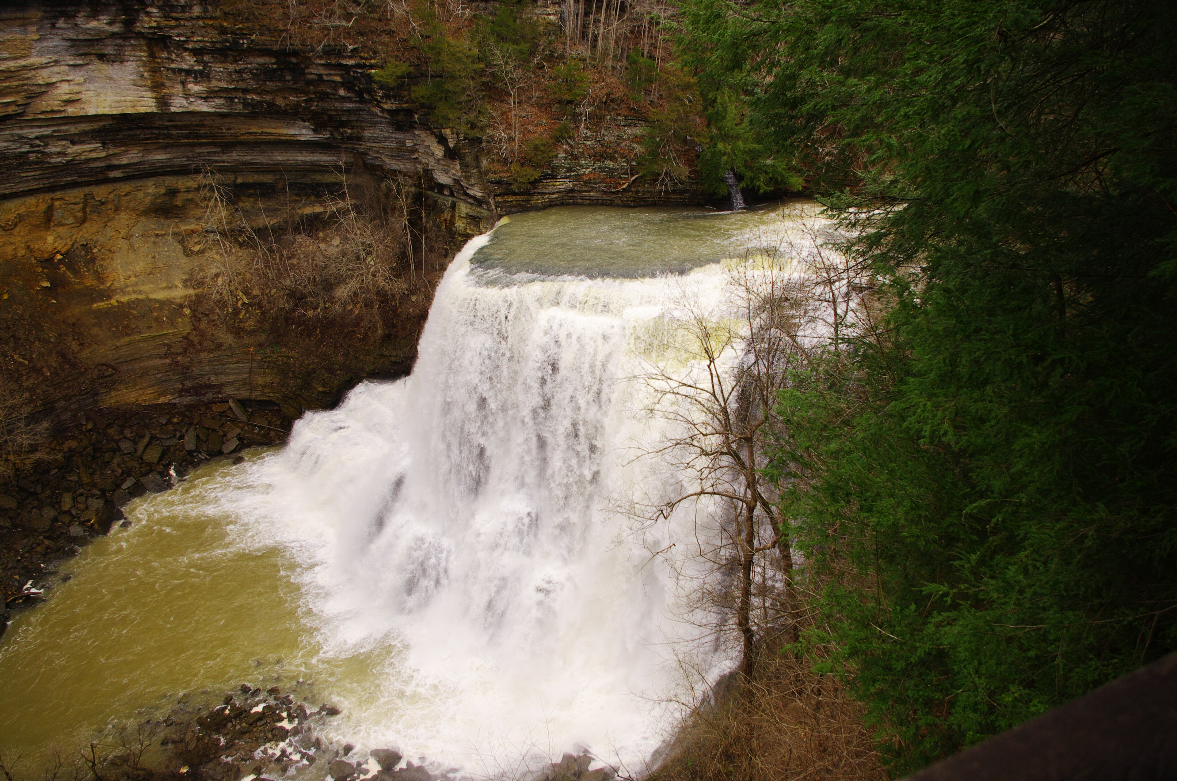

Most waterfall hikes make you earn one waterfall. Burgess Falls gives you four in three quarters of a mile, and the last one is the best.
The Falling Water River runs across the western edge of the Cumberland Plateau and then falls off it, dropping more than 250 feet in elevation in the short distance before it meets the backwater of Center Hill Lake. It does this in four distinct stages, and the trail follows the whole sequence.
The park is small, free, and about twenty minutes from Cookeville.
The four falls, in order
The cascades come first, a broad shelf of water sliding over bedrock just below the old dam, easy to walk past and worth stopping for. The Little Falls is second, a modest but pretty drop of around twenty feet. The Middle Falls is third at roughly eighty feet, and it is the one that surprises people, because by any normal standard it would be the headline attraction of its own state park.
Burgess Falls itself is the fourth, plunging more than 130 feet into a wide amphitheater cut into the limestone and shale. The overlook at the top of it is the end of the maintained trail for most visitors, and the view down into the gorge is the reason the park exists.
The whole sequence is under a mile of walking with modest elevation change until the very end.
The stairway, and why you probably cannot go down
This is the part to check before you drive. A staircase and a steep spur once ran from the overlook down to the base of the main falls, and standing at the bottom looking up was the highlight of the park for a great many people. It has been closed for extended periods following storm damage and rockfall, and the base of the falls has spent years unreachable.
Assume it is shut and treat access to the plunge pool as a bonus rather than the plan. The overlook trail is the park, and it is enough.
This matters more here than at a larger park because Burgess Falls is small, so if the descent is closed and you were counting on it, you have driven out for a forty-minute walk. That is the case for checking current status rather than a guidebook, because a single closed staircase changes what this park is, and it has opened and shut repeatedly over the past decade. Guidepole Hike carries closures against the specific route rather than the park, which at a place this compact is the difference between a good morning and a wasted drive.
Why the river behaves like this
The geology is the same story that produces waterfalls across this whole region, and here it is unusually legible because you see four stages of it at once. The Cumberland Plateau is capped with resistant sandstone over softer shale and limestone, so a river crossing the flat top runs quietly until it reaches the edge, then begins cutting down through the stack.
Where it meets a hard layer it slides. Where it undercuts a hard layer, the softer rock beneath washes out and the cap eventually collapses, which produces a vertical drop and, over time, moves the drop upstream. The four falls here are four different points in that process on a single river, and the main falls has cut the deepest amphitheater because it has been working the longest.
The dam, and the town that isn't there
There is a small concrete dam at the head of the trail, and it is the remnant of something larger. The Falling Water River's drop was obvious water power and it was used, with a mill operating here from the early nineteenth century and, in the 1920s, the City of Cookeville building a hydroelectric plant on the river to supply the town. The dam you walk past is what is left of that scheme.
The plant was destroyed by a flood in 1928, rebuilt, and eventually abandoned when larger regional generation made it redundant, after which the land passed to the state and the park was established in the 1970s.
What this means on the ground is that the first section of trail is not wilderness. It is an industrial site that the forest has taken back, and the concrete, the channel and the odd bits of masonry are all part of the story of why a small river on the plateau edge was worth owning. The name comes from Tom Burgess, who received the land as a grant for service in the War of 1812.
The walk itself
The main trail runs along the river on the eastern bank, dropping gently, with viewpoints at each fall, and it is well built, popular and busy on weekends. The return can be made on the Ridge Top Trail, which climbs away from the river and loops back through upland hardwood, turning an out-and-back into a loop and being markedly quieter, while the service road offers a third and easier return for anyone who does not want the steps.
Footing is the usual plateau problem, meaning exposed limestone slabs that are slick with algae wherever they stay damp, plus roots and steps. And do not scramble off-trail toward the base, because the gorge walls here are undercut and loose, the park closes routes for good reason, and rescues from this gorge are difficult.
The forest, and what is happening to it
The walk down the river passes through mixed mesophytic forest, the botanically rich temperate forest type that covers the Cumberland Plateau and the southern Appalachians, where no single species dominates the canopy and oak, hickory, tulip poplar, maple, beech, basswood and hemlock share the slopes.
The gorge compresses that further, because the cool damp north-facing walls support species that properly belong hundreds of miles north while the drier slopes opposite are oak and pine, which makes it a short walk between two different forests.
Eastern hemlock is dying here as it is across the region, killed by the hemlock woolly adelgid, an introduced insect that has been working through Appalachian hemlock for two decades, and the standing gray trunks in the gorge are its work, taking with them the deep shade that kept the streamside cool. Spring ephemerals on the slopes are excellent in late March and April before the canopy closes, with trillium, bloodroot, hepatica and dutchman's breeches.
Watch This Before Visiting Burgess Falls State ParkWhen the water runs
This is the other thing that decides whether the trip is worth it. Winter and early spring are the season, because the Falling Water River drains a relatively small plateau catchment and after a wet January the main falls is thunderous.
Late summer is thin. In a dry August the volume drops sharply, and visitors who arrive expecting the photographs they have seen are frequently disappointed, because the rock is still impressive and the water may not be. After heavy rain the river runs hard and the trail gets slick, and the park closes sections when conditions warrant. Autumn brings the plateau hardwood color in late October and moderate water.
The gear
Burgess Falls is a short trail past four waterfalls, and the whole gear list is about wet limestone and about one recurring closure.
Shoes with grip on wet limestone, which is the surface for the entire River Trail. The rock stays damp from spray and shade, and the descent to the base of the big falls is where people fall.
A current park status check before you drive, which is necessary here. The stairway to the base of the main falls has been closed for extended periods after storm damage, and the park has had to rebuild access more than once. A trip planned around reaching the base is a trip that can be wasted.
Trekking poles, for the same descent.
Tick and chigger repellent, for the plateau summer.
A rain shell, since the best water is after rain and the spray at the base is heavy enough to soak you regardless.
A camera that tolerates spray, or a bag for one that does not.
And offline maps, which matter less here than at the bigger parks but still matter in the gorge.
The lake at the bottom
Below the main falls the river enters the backwater of Center Hill Lake, a Corps of Engineers reservoir on the Caney Fork completed in 1948, and that matters to what you see. The gorge below the falls is drowned to a depth that varies with the reservoir level, so the pool at the base is deeper and stiller than the river alone would make it, and in a summer drawdown the character changes noticeably.
There is a boat ramp on the lake side of the park, and arriving by water is a legitimate and rarely used way to see the falls from below.
Hiking the River Trail to Four Waterfalls at Burgess FallsReading a plateau waterfall
Once you have seen four falls on one river the pattern becomes readable, and it makes every other waterfall in this region more interesting.
Look for the overhang, because a plateau waterfall almost always drops clear of an undercut as the soft rock beneath the hard cap erodes faster, and the deeper the amphitheater, the longer that fall has been working at the same spot. Look at the plunge pool, since the falling water drills downward as well as backward and the pool below a mature fall is often far deeper than the stream above it.
Look upstream of the lip too, because a waterfall migrates upstream over time as the cap collapses, so the stretch immediately above a fall is frequently a narrow slot cut into the caprock, a record of where the drop used to be. Look at the talus, where blocks of sandstone piled at the base are the collapsed cap and their size tells you how thick the resistant layer is. And count the steps, because a river crossing several hard layers produces several falls, which is exactly what the Falling Water River does here, each at a different stage of the same process.
The Cumberland Plateau has more waterfalls than almost anywhere in the eastern United States for one reason: a hard flat cap over soft rock, cut by a great many streams, along an escarpment hundreds of miles long. Burgess Falls is the compressed version, which is why it makes such a good introduction.
Getting there, and the rest of the plateau
The park sits between Cookeville and Sparta, about twenty minutes from either, reached on county roads off Highway 135, and it is close enough to I-40 that it works as a break on a Nashville to Knoxville drive, which is how a lot of people first find it. Arrive early on any warm Saturday, because the lot is small and there is no overflow worth speaking of, though mid-week in winter you may have it to yourself. Check the seasonal hours as well, since the park closes considerably earlier in winter than in summer and the gate is real.
There is no entrance fee and no parking fee, as at every Tennessee state park. It is day-use only with no camping, facilities are minimal at toilets and a picnic area, dogs are welcome on leash, and signal is patchy and gone in the gorge. Swimming is not permitted below the main falls, and the current and undercut rock make it a bad idea regardless. Copperheads are present, along with ticks and chiggers from spring through autumn.
Burgess Falls is small enough that it works best as one stop on a day rather than the whole day, and it is well placed for that. Cummins Falls is about half an hour north with its permit-controlled gorge and a free overlook, Rock Island State Park is roughly twenty miles away where a waterfall pours out of the side of a cliff, Fall Creek Falls is an hour south and holds nearly 30,000 acres, and Virgin Falls is southeast, a much harder nine-mile day into a wilderness area.
All of them are free. A weekend based in Cookeville or Sparta can cover four of the best waterfalls in the eastern United States without paying an entrance fee once, which is an unusual thing to be able to say.
The fee picture across the region is in six states, six ways to charge you for a trailhead. Nearby: Cummins Falls, Rock Island, Fall Creek Falls and Virgin Falls. The long route down the escarpment is the Cumberland Trail.
The neighboring plateau waterfall parks are in Cummins Falls, Fall Creek Falls and Rock Island State Park. The remote version of the same landscape is in Virgin Falls and Savage Gulf. The trail that connects much of this plateau is in the Cumberland Trail.
A note on the geology, since it explains why there are four falls rather than one. The Falling Water River drops off the Highland Rim onto the Central Basin in a series of steps, and each step is a bed of harder limestone sitting on softer shale. The river undercuts the shale, the limestone lip breaks off, and the falls retreat upstream a little further. What you are walking past is the same waterfall at four stages of its own retreat, and in geological terms it is moving.