Fish
Fish Fire
Fire Hike
Hike Bird
Bird


Tennessee is the one state in this region that charges nothing to enter a state park. No entrance fee, no day-use parking fee, at any of its parks, since 2006.
Cummins Falls is where that policy meets its limit, not because the state changed its mind about access, but because of what happened in the gorge here.
Getting to the base of the falls now requires a Gorge Access Permit: $7 per person, 200 issued per day, bookable up to three months ahead on a rolling basis, and only valid on fair-weather days. Weekends and holidays sell out first. The overlook, and the rest of the park, remain free.
What happened
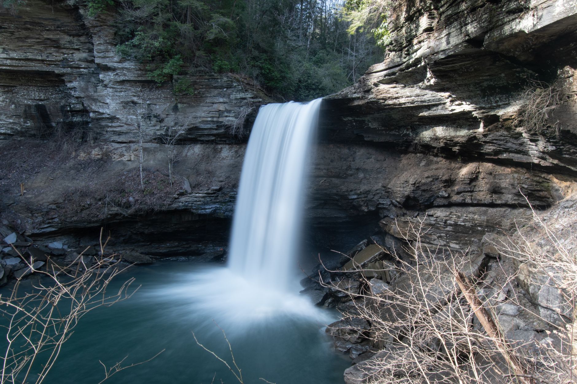
The Blackburn Fork cuts a gorge into the Cumberland Plateau's western edge, and Cummins Falls drops about 75 feet into a wide pool at the bottom of it. The pool, the terraced rock and the cascades below made it one of the most popular swimming holes in Tennessee.
The problem is hydrological. The gorge drains a large, flat plateau catchment upstream, and when heavy rain falls on that catchment, which can be miles away and out of sight under a clear sky where you are standing, the water arrives in the gorge as a wall, within minutes, with no warning. There is no quick way out, because the gorge walls are steep, the exit route is a scramble, and a hundred people in swimwear at the bottom of it cannot move fast.
In June 2019 a flash flood swept through. A two-year-old boy, Steven Pierce, died. Sixty-three people were rescued. It was not the first serious incident here, and a flood warning system that had been announced two years earlier had not been installed. The park closed the gorge, and when it reopened it did so with the permit system that exists now.
What the permit does
It does two things and they are worth separating. It caps the number of people in the gorge at 200 a day, which means an evacuation is a manageable problem rather than an impossible one. And it creates a list, so the park knows who is down there, which is the part that matters most in an emergency and the reason the system is not simply a line at the trailhead.
The fair-weather condition is the third element. The gorge closes when conditions or forecasts warrant, and a permit is not a guarantee of access, so if the gorge is closed on your date you do not get in, and this is not negotiable.
Seven dollars is not a revenue measure. It is the price of a managed risk in a place that had demonstrated the risk was real.
The two different hikes
This is the practical distinction to get right before booking anything. The Waterfall Overlook Trail is free, requires no permit, and takes you to a viewpoint above the falls, with some stairs and uneven ground along the way. If you want to see Cummins Falls and go home, that is the trip, and it costs nothing.
The Gorge Access route is the permitted one, and it is a demanding outing that people consistently underestimate. It descends steeply into the gorge and then requires walking up the riverbed itself, over slick rock and through moving water for a considerable distance, with no dry route, so you will be wet to the waist or beyond. It is roughly a mile and a half each way from the trailhead, and it takes most people far longer than a mile and a half suggests.
Two routes from one parking lot, one free and unlimited and one permitted, capped and weather-conditional, is an unusually sharp version of a problem that shows up all over American public land: the requirement attaches to the route rather than the park. Guidepole Hike carries the permit against the specific trail and its current status, which here is the difference between booking something you did not need and turning up without something you did.
What the gorge walk is like
You are hiking in a river rather than beside one, because the route follows the Blackburn Fork upstream over rounded, algae-covered limestone under moving water. Footing is the whole problem, since wet limestone is slippery, the rock is uneven and depths change without warning, and ankle and wrist injuries are the routine outcome.
Water shoes are not optional, because bare feet, flip-flops and ordinary sneakers all fail here, and closed-toe shoes with grip that you are willing to soak are the minimum. The climb out is the hard part, since after a few hours in the water the steep ascent back to the rim in Tennessee humidity is where people struggle. There is no shade in the pool area in the middle of the day and the gorge holds heat. And children need supervision, because the combination of moving water, slick rock and drop-offs is not a paddling pool.
Booking it properly
Permits go three months ahead on a rolling 90-day basis, and weekends and holidays go first. Weekdays and shoulder season are readily available, often the day before, so if your schedule flexes at all that removes the whole problem.
The park operates seasonally, generally 8 a.m. to 6 p.m., and gorge access is a daylight activity with a hard cutoff. Check the forecast and the park's status the morning you go, because upstream rain closes the gorge regardless of the sky above the parking lot, and that is the entire point of the system. And have a fallback, since Burgess Falls is twenty minutes away and Cookeville sits within an hour of a great deal of plateau gorge country.
Why plateau gorges flood the way they do
This is worth understanding properly, because the same physics applies across a great deal of Tennessee hiking and Cummins Falls is where it has been demonstrated most publicly.
The Cumberland Plateau is a broad flat upland with thin soil over sandstone, so rain falling on it does not soak in the way it does on a deep-soiled hillside. It runs off fast, across a wide catchment, and gathers into the streams that have cut down into the plateau edge. Those streams then run in narrow steep-walled gorges with almost no floodplain, so a volume of water that would spread harmlessly across a valley bottom has nowhere to go here except up the walls.
The result is a rise that is fast and vertical rather than gradual, and gauges on plateau streams routinely record several feet inside an hour. There is no meaningful warning at the bottom, because the sky above the gorge can be clear while the storm sits over the catchment several miles upstream. And the exits are the problem, since a gorge with steep walls and a single scramble route out cannot be evacuated quickly, and a crowd of people in swimwear on wet rock moves very slowly.
This is why the permit system caps numbers rather than just charging a fee, and why the fair-weather condition is non-negotiable. It is also why the same caution belongs at Savage Gulf, Fall Creek Falls, Burgess Falls and every other plateau gorge. Cummins Falls is not uniquely dangerous; it is the one where the lesson was learned in public.
The Cummins Falls Hike, Cummins Falls State ParkThe rest of the park
There is more here than the falls, and it is free. The park covers a few hundred acres along the Blackburn Fork, with trails on the rim above the gorge on both sides. The Downstream Trail follows the river below the falls and gives a different perspective on the gorge without requiring the permit, and the rim trails are pleasant walking in mixed hardwood and are where you go when the gorge is closed, which over a year is a substantial proportion of the time.
Cummins Falls was privately owned until 2011, when a conservation purchase brought it into the state park system, and before that it was a locally known swimming hole reached by informal access. The transition from an unmanaged local spot to a state park with 200 daily permits, in barely a decade, is most of the story of what happened here.
The gear
Cummins Falls has the most specific gear list of any Tennessee state park, because the route to the base is a river rather than a trail.
Closed-toe water shoes with real grip, which is the single most important item. You are walking down a creek bed on wet limestone, sandals come off, bare feet get cut, and hiking boots fill with water and stay full.
A dry bag, since everything you carry is going in the water at some point.
Trekking poles, for the same reason poles help on a river crossing: they are two extra points of contact on a slick uneven bottom.
A weather check for rain upstream, and this is the item that is about safety rather than comfort. The gorge floods fast and it has killed people. The upstream watershed can be receiving rain while the parking lot is dry, and the park closes the gorge on that basis.
More time than you planned, because the descent takes longer than the distance implies and the climb back out takes longer still.
Sun protection, since the creek bed is open and the middle of the day on limestone is bright.
And a booked gorge access permit, which is required, is limited by day, and is released about three months ahead. Without one you can see the overlook and nothing else.
If you are bringing children
This needs saying separately, because families are the largest group here and the gorge is marketed on its swimming.
The overlook trail is the right answer for most families. It is short, it involves stairs and uneven footing but nothing technical, and it delivers the waterfall.
If you take children into the gorge, the honest requirements are a child confident on slippery uneven ground in moving water, one adult per small child in the water, properly fitted closed-toe water shoes on everyone, and a realistic view of the climb out at the end of a long wet day. Life jackets for small children in the pool area are a reasonable precaution and nobody will think less of you for it, because there are no lifeguards, the pool has current, and the depth changes without warning.
And the weather rule is absolute. The permit system exists because a two-year-old died here, so if the park closes the gorge on the day you booked, that is the system doing exactly what it was built to do.
Cummins Falls State Park: Before You VisitSeason, and getting there
Summer is when most people come, because the point for many visitors is the swimming and the water is tolerable. Late spring and early autumn are the better hiking conditions and the gorge is less crowded. Winter and early spring bring the highest and most dangerous water and the gorge is frequently closed, though the falls themselves are at their most impressive from the overlook in exactly that period, which is a neat argument for the free trail. After any significant rain, assume the gorge is shut.
The park is about ten minutes north of Cookeville, which sits directly on I-40 roughly halfway between Nashville and Knoxville, an hour and a half from either. That position is most of the reason it became as popular as it did, because it is the nearest spectacular waterfall to a very large number of people, on a straightforward drive. The final approach is on narrow county roads and the parking lot is small, so it fills on summer weekends even with the permit cap, because the overlook trail has no limit on numbers.
Two more practical notes: signal is gone in the gorge, and dogs are a bad idea down there regardless of policy, because slick rock, moving water and a steep exit are a poor combination for them.
The honest recommendation
If you want a waterfall photograph and an hour outdoors, walk the free overlook trail and skip the permit entirely. Most visitors would be happier doing this and do not realize it is an option.
If you want the gorge, book a weekday, bring proper water shoes, budget four hours rather than two, and take the closure rules seriously, because the system exists for a specific and recent reason, and everybody working at that park remembers it.
Tennessee's fee-free policy and the rest of the region's systems are in six states, six ways to charge you for a trailhead. More plateau gorge country at Fall Creek Falls and Savage Gulf, the long route down the escarpment at the Cumberland Trail, and the flash-flood reasoning generalized in river and creek crossings.
The other plateau waterfall parks are in Burgess Falls, Fall Creek Falls and Rock Island State Park. The nearest city is in birding Nashville, the permit system that governs access here is the kind described in hiking permit lotteries explained, and Tennessee's unusual no-fee state park policy is covered in state park passes by state.