Fish
Fish Fire
Fire Hike
Hike Bird
Bird

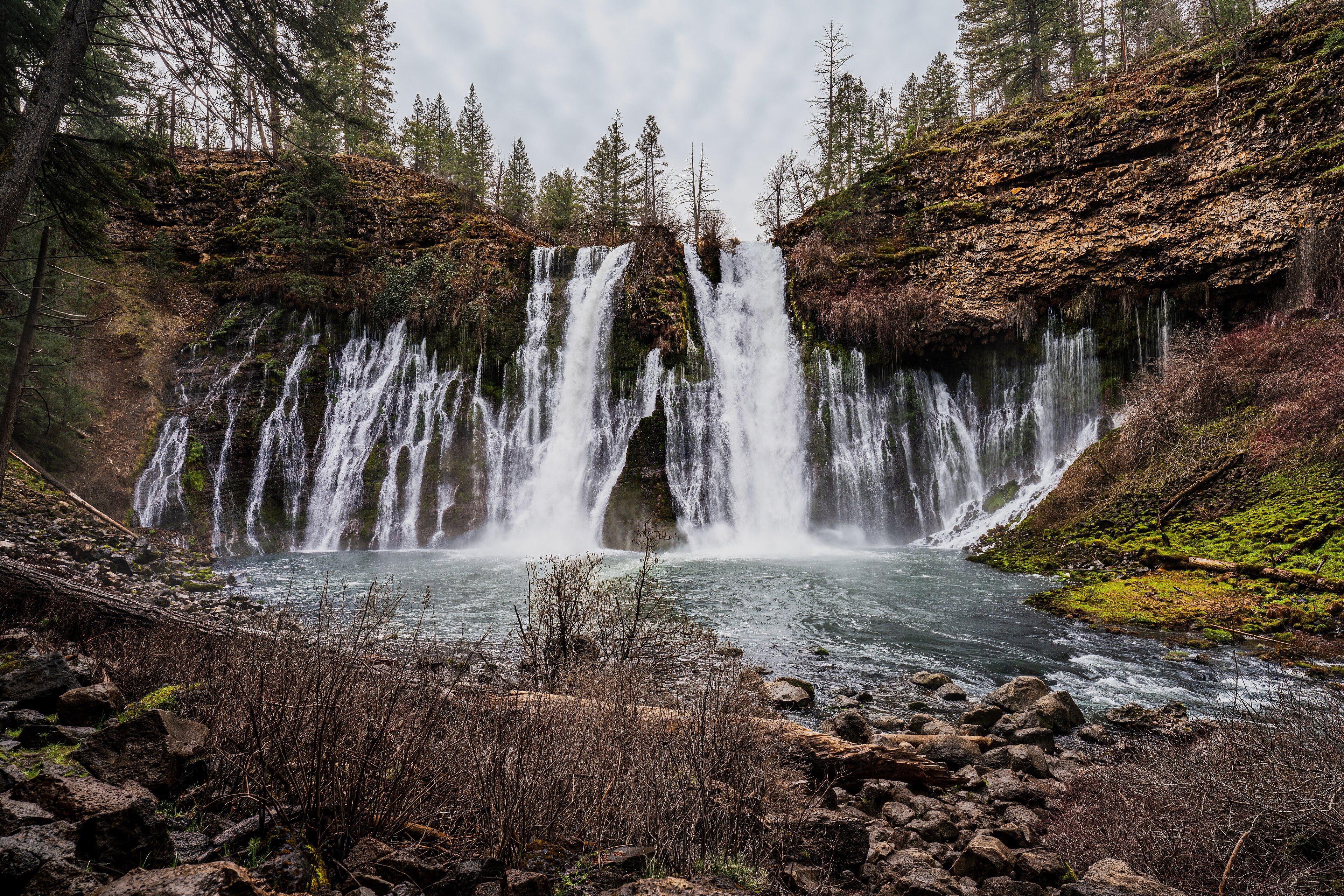

In late September in northern California, after five months without rain, most waterfalls are a damp streak on rock.
Burney Falls is running at roughly a hundred million gallons a day, exactly as it was in April, and exactly as it will be next February.
The reason is that it is not really a river falling over a cliff. It is an aquifer coming out of one.
How it works
The Cascade Range here is built from young, porous volcanic rock: basalt flows and volcanic debris riddled with cracks, tubes and voids. Snowmelt and rain falling on that landscape does not run off, it sinks, traveling underground through the porous rock for sometimes miles, in an enormous groundwater system beneath the whole area. Where that saturated rock is cut by a canyon, the water comes out.
At Burney Falls, Burney Creek contributes only part of the flow and in late summer it can be dry above the falls entirely. The rest, the great majority, emerges directly from the face of the cliff through the layered volcanic rock, in dozens of separate springs and seeps spread across the whole 129-foot wall.
That is why the falls looks the way it does: not a single plunging column but a broad curtain, with water pouring out of the rock face itself at every level and moss growing where the seeps are permanent. And it is why the volume barely changes, because groundwater does not care what the weather did last week.
Theodore Roosevelt and the eighth wonder
The park's marketing leans heavily on a quotation attributed to Theodore Roosevelt calling Burney Falls the eighth wonder of the world. The attribution is not well documented and historians have found no reliable source for it, though it appears on signage and in tourist literature and has done for decades.
What is documented is that the falls and surrounding land were donated to the state in 1920 by the McArthur family, pioneer settlers who had acquired it years earlier, which is why the park carries the family name alongside the falls. It became a National Natural Landmark in 1954.
The quotation is probably apocryphal. The waterfall does not need it.
The walking
The park is small, around 900 acres, and the essential walk is short. The Falls Loop Trail is roughly 1.2 miles and is the whole reason to come, leaving the overlook, descending to the base of the falls through mist, crossing the creek below, then climbing the far side before returning across a bridge above the lip. It is paved and stepped in sections, drops and regains about 200 feet, and takes an hour with stops.
Standing at the base is the point, because the spray is constant, the noise is considerable, and you can see the individual springs emerging from the cliff at every height. Beyond that, the Burney Creek Trail continues downstream toward Lake Britton, and the Rim Trail and Headwaters Trail add a few flat miles, while Lake Britton has a beach, boat launch and swimming with the campground sitting between the two.
The people who were here
This country is the homeland of the Ilmawi and other bands of the Pit River Tribe, and the falls has significance in that context beyond its use as scenery. The Pit River people occupied a large territory across northeastern California in eleven autonomous bands, living on salmon, deer, acorns and roots, with the rivers and springs as the organizing feature of the landscape. The name of the Pit River comes from the pit traps dug along game trails, described by early American arrivals.
The nineteenth century here was violent. Settlement, mining and ranching displaced the bands rapidly, and a series of killings and forced removals through the 1850s and 1860s reduced the population sharply. The Pit River Tribe is federally recognized today and remains active in land and water issues across the region, including in disputes over the hydroelectric development on the river that carries its name.
The falls itself, in a landscape where reliable water is the determining resource, was not an incidental feature to the people who lived here.
The Pacific Crest Trail through here
Burney Falls occupies a particular place in the mythology of the PCT. Northbound hikers arrive after the Hat Creek Rim, a roughly thirty-mile stretch of exposed volcanic plateau with essentially no water and no shade, walked in the heat of northern California summer, and it has a reputation as one of the more miserable sections of the entire trail.
They then descend into a state park with a hundred million gallons a day pouring out of a cliff, a store, a campground and cold water everywhere. The contrast is not subtle, and Burney Falls has become one of the emotional landmarks of a northbound thru-hike, with the park running a PCT hiker campsite and the store holding resupply boxes.
For a day visitor this matters mainly as context: the people with enormous packs and thousand-yard stares eating ice cream by the store have walked here from Mexico. The trail continues north toward Castle Crags and the Trinity Alps, and the section immediately north of the park along Lake Britton is pleasant and easy walking if you want a taste of it.
The volcanic country around it
The falls only makes sense as part of a much larger volcanic landscape, and the neighbors are worth the trip. Lassen Volcanic National Park, an hour south, contains all four types of volcano found in the world and an active hydrothermal system with boiling mud pots, fumaroles and sulfur vents, and Lassen Peak erupted between 1914 and 1917, the last eruption in the contiguous United States before Mount St. Helens.
Subway Cave near Old Station is a lava tube you walk through with a flashlight, a third of a mile long and completely dark. Medicine Lake Volcano further north is the largest volcano by volume in the Cascade Range, though it is a broad shield that almost nobody recognizes as a volcano at all, and Lava Beds National Monument near the Oregon line holds hundreds of lava tube caves you can enter freely.
All of it is the same story: young porous volcanic rock, water disappearing into it, and water reappearing somewhere unexpected. It is also, administratively, five different managers within two hours, running from a state park to a national park to a national monument to national forest to utility land around the reservoir, each with its own rules on dogs, caves, fees and camping. Guidepole Hike carries the managing agency under each trail, which across a volcanic province stitched together this way saves working out which set of rules applies to the cave you are about to walk into.
Burney Falls: One of the Best Waterfalls in CaliforniaThe Pit River, the dams, and the fishing
Below the falls, Burney Creek joins the Pit River, and the Pit is one of the more heavily engineered rivers in California. It drains a large part of northeastern California and carries a substantial flow, much of it groundwater-fed and therefore unusually steady, which makes it excellent for hydroelectricity, and Lake Britton, the reservoir immediately below the falls, is one of a chain of impoundments along it. The steadiness is the same phenomenon that keeps the falls running, because this is groundwater country and groundwater does not have a wet season and a dry season the way a surface river does.
The railway trestle across Lake Britton, visible from the park, appeared in the 1986 film Stand by Me, which is a small piece of trivia that a surprising number of visitors arrive knowing.
The same groundwater supports a serious fishery. Lake Britton holds bass, crappie and trout with a boat launch and shoreline access in the park, and Burney Creek below the falls is cold and clear year-round. Hat Creek, half an hour south, is one of the most storied and most technically difficult wild trout streams in California, a spring-fed spring creek with clear slow water and extremely selective fish that has been a proving ground for American fly fishers for decades, and the Fall River further east is similar and equally famous. The common factor is the aquifer: constant flow, constant temperature, high productivity, and water clear enough that the fish can see everything you do wrong.
The gear
Burney Falls runs at roughly the same volume every day of the year, which makes it the most reliable waterfall in this library and shapes the list oddly.
A rain shell, not for the weather but for the spray, which at the base of the falls is constant and heavy.
A lens cloth, for the same reason, because this is one of the most photographed waterfalls in California and almost every attempt is ruined by water on the front element.
Shoes with grip, for the Falls Loop Trail, which is short, paved in part and wet throughout.
An early start in summer, since the lot fills and the park caps entry when it does.
Swimming things, for Lake Britton, which is a good swim and which most visitors to the falls never see.
A Golden Poppy pass if you use California state parks regularly.
And warm layers in winter, because this park sits at three thousand feet in the southern Cascades and it gets snow. The falls in snow is the best version of it and almost nobody comes then.
Photographing it
A north-facing cliff in a canyon with permanent spray is a difficult subject, and a few specifics help. Morning light is the answer, because the falls faces roughly north and sits in shadow through most of the afternoon while the rim above stays bright, which is a contrast range that defeats most cameras. Overcast is better than sun, since even light across the whole face shows the springs emerging at every level, which is the interesting part.
A polarizer cuts the glare off wet basalt and deepens the greens on the mossy sections. Long exposures smooth the water, though the falls has so much texture from the individual springs that a faster shutter often shows more. The base of the loop gives the dramatic upward angle, the bridge above the lip gives the profile, and the overlook gives the postcard. And protect the lens, because spray at the bottom coats glass within a minute.
McArthur-Burney Falls Memorial State Park Travel GuideSeason, and practical notes
Because the falls is spring-fed, the season question is about everything except the water. Summer is hot and busy with the lake swimming as the draw and the parking filling. Autumn is excellent, being warm and quiet with the falls unchanged. Spring brings wildflowers and the creek above the falls running. And winter is cold, occasionally snowy at 3,000 feet, very quiet, with the falls able to frame with ice at the edges and some facilities closed. The falls looks the same in every one of those photographs, which is the strangest and best thing about it.
A day-use parking fee applies and the Golden Poppy annual pass at $125 covers most California day use. Camping at the park and the cabins book six months ahead, because it is a popular summer destination. Dogs are restricted to the paved areas and campground rather than the Falls Loop, as across the California system. It is about an hour east of Redding off Highway 89 and roughly five hours from San Francisco, at about 3,000 feet, which makes it cooler than the Central Valley below. Signal is limited. And the overlook is a two-minute walk from parking and fully accessible, which means the falls is visible to anyone regardless of mobility.
What to do with a day
Arrive early, because the parking fills in summer and the light on the falls is better in the morning. Walk the Falls Loop, 1.2 miles, and spend time at the base.
Then look at the cliff face rather than the water. Once you see that the falls is emerging from the rock at every level rather than pouring over the top, the whole thing reorganizes itself in your head.
After that, swim in Lake Britton if it is warm or walk downstream toward it if it is not, and add Lassen Volcanic National Park an hour south, or the Subway Cave lava tube, which are part of the same volcanic system that makes the falls possible.
California's other water is at Big Basin and along the coast at Point Lobos. The state's rules are in six states, six ways to charge you for a trailhead, and the volcanic country north of here continues into Crater Lake.
The other northern California parks are in Humboldt Redwoods and Prairie Creek and Fern Canyon. The refuges an hour north are in the Klamath Basin refuges, and the Oregon park across the line is in one day at Crater Lake. The pass structure is in state park passes by state.
A note on the quotation everybody repeats, since it deserves a caveat. Burney Falls is routinely called the eighth wonder of the world on the authority of Theodore Roosevelt, and no primary source for him ever saying it has been produced. What is documented is the geology, and it is more interesting anyway: the falls run at a nearly constant hundred million gallons a day because most of the water is not coming over the lip at all. It emerges from springs in the porous volcanic rock of the face itself, fed by an aquifer that does not care what the weather did last week.