Fish
Fish Fire
Fire Hike
Hike Bird
Bird


If you are planning a trip to Crater Lake in the next three summers, start with the thing that changes the plan.
The Cleetwood Cove Trail is closed for the 2026, 2027 and 2028 seasons for a major rehabilitation project, with reopening expected in 2029 if the work goes as scheduled. It is the most heavily used trail in the park and the only legal access to the shore of the lake, and everything that happens on the water leaves from the dock at the bottom of it: the boat tours, the Wizard Island shuttle, and the one place in the park where swimming is permitted.
All of that is gone until the trail comes back.
The project is not cosmetic. Crews are scaling loose rock off the cliffs above the trail, rebuilding the tread and its retaining walls, replacing a failed bulkhead and dock with a structurally sound marina, and replacing undersized composting toilets. It is running three years because the construction season at 6,000 feet in the Cascades is roughly July to September.
So: no boat, no island, no swim. Here is what a day at Crater Lake looks like now, and the honest version is that the rim hikes were always the better half of this park.
What you are looking at
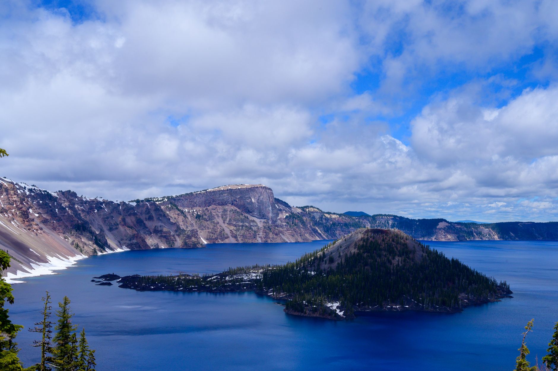
This is worth two minutes, because it makes the rest of the day better. About 7,700 years ago a volcano now called Mount Mazama, a stratovolcano of perhaps 12,000 feet, erupted catastrophically and then collapsed into its own emptied magma chamber, and the hole it left is the caldera, roughly five by six miles across.
It filled with snowmelt and rain, and it is still filling and evaporating in balance. Crater Lake has no inlet and no outlet, so no river runs in carrying silt and none runs out, which means the water is almost entirely precipitation and is among the clearest large bodies of water anywhere measured. That is the whole explanation for the color, because deep and exceptionally pure water absorbs the long wavelengths of light and scatters the short ones back, and with no sediment to interfere the effect is uninterrupted. At 1,943 feet, it is the deepest lake in the United States.
Wizard Island is a cinder cone built inside the caldera after the collapse, Llao Rock is the great cliff on the northwest rim, and Phantom Ship is a spire of much older rock in the southeast corner. The Klamath people were here for the eruption, and their oral tradition preserves it as a battle between Llao, of the underworld, and Skell, of the sky. That is not a legend layered onto a landscape afterward. It is a description of an event, carried for seven millennia.
The Garfield Peak Trail, Crater Lake National ParkThe rim hikes, which are the point now
Three summit trails come off Rim Drive, and doing any two of them is a full and excellent day.
Garfield Peak is the one to do if you only do one. It leaves directly from Crater Lake Lodge at Rim Village, which means no extra driving, and climbs about 3.4 miles round trip with roughly 1,000 feet of gain to an 8,054-foot summit, the fourth highest point on the rim. The trail is mostly open and traverses above the lake almost the whole way, the view back over the caldera from the top is the best accessible one in the park, and the wildflowers along it in late July are excellent.
The Watchman is the short one and punches far above its weight: about 1.7 miles round trip with 400 feet of gain on the West Rim Drive, climbing to a fire lookout built in 1932 that rangers still use. It sits above 8,000 feet directly over Wizard Island, which makes it the best place in the park to photograph the island, and it costs half an hour to an hour of walking. Do it at sunset.
Mount Scott is the big one, about 4.4 miles round trip with 1,272 feet of gain from the East Rim Drive, climbing to 8,929 feet and the highest point in the park. From the top you get the entire caldera on one side and, on a clear day, a long stretch of the Cascades from Shasta to the Three Sisters on the other. This is the summit that makes you understand how big Mazama was.
The Watchman Peak Trail, Crater Lake National ParkThe rest of a day
Rim Drive itself is 33 miles around the caldera with something like thirty pullouts, and driving it slowly is a legitimate way to spend three hours, with the East Rim the quieter half. Off it, Plaikni Falls is a 2-mile round trip on gentle, largely accessible trail through old forest to a waterfall fed by snowmelt off the Anderson Bluffs, a good counterpoint to a day of rim views and one of the few places in the park with a creek.
The Pinnacles are 60-foot spires of welded ash standing in a canyon on the far east side, formed as volcanic gas vents fossilized the ash around them and the creek then cut away everything softer, reached by a short flat walk and geologically the strangest thing here. Godfrey Glen is a mile-long loop through old-growth hemlock above a canyon of the same pumice formations.
Two more are worth the few minutes each costs. Discovery Point is a flat two miles along the rim from Rim Village, and the Pacific Crest Trail passes through the park with a rim alternate that many thru-hikers take for the view. And Sun Notch is a ten-minute walk to the best view of Phantom Ship.
The season is short
This is the second thing that ruins trips here, after the closure. Crater Lake is one of the snowiest inhabited places in the United States, averaging in the region of forty feet a year, the rim sits above 7,000 feet in places, and the snow does not leave on any schedule that suits a vacation.
Full Rim Drive typically opens sometime in July and closes with the first serious storms, often in October, and in a heavy year the opening slips later, with the north entrance and the East Rim the last to clear. The south entrance and Rim Village stay open year-round, which is why winter visits are possible at all, since you can reach the rim, look at the lake, and snowshoe on ranger-led trips.
July through September is the hiking season, full stop. In June you will find the rim trails still under snow while the lake is perfectly blue and the road is closed past Rim Village. Snow can fall in any month here and August storms are not unusual. Smoke is the other August and September variable, and southern Oregon gets it badly, so in a bad week the lake is invisible from the rim, which is a dispiriting way to spend a park visit.
Between a three-year trail closure, a Rim Drive that opens on the snowpack's schedule rather than the calendar's, and a north entrance that may or may not be through, this is a park where what is actually open decides the day more than the weather does. Guidepole Hike carries current road and trailhead access status alongside the routes, which here means finding out before the four-hour drive rather than at the gate.
The gear
Crater Lake sits on a rim at seven thousand feet in a range that gets more snow than almost anywhere in the country, and the gear list is shaped by altitude and exposure.
Layers for a seven-thousand-foot rim, because the rim is consistently colder and windier than the drive up suggests, and a July afternoon at Rim Village with wind off the lake is a jacket afternoon.
Serious sun protection, which is the item that catches people. Seven thousand feet of thin air, a treeless rim, and a very large reflective lake add up to more ultraviolet than most visitors have experienced, and the classic Crater Lake souvenir is a burnt face and neck.
More water than you expect, since the rim hikes have none and the air is dry.
An air quality check, which has become a real planning step. Late-summer smoke from regional fires now regularly obscures the lake entirely, and there is nothing else to do here when it does.
A wind shell.
Traction devices in the shoulder season, because the rim holds snow into July in an average year and the trails to Garfield Peak and the Watchman open later than the road does.
And a full tank of fuel, since the park has limited fuel at Mazama Village in season and none at all outside it, and the nearest reliable stations are in Chiloquin and Prospect.
Getting there, and which entrance
Crater Lake is remote, and underestimating the drive is the third way people spoil this trip. The south entrance off Highway 62 is the main one and the only one open year-round, leading to Mazama Village and then climbing to Rim Village, and it is roughly two hours from Medford, about an hour and a half from Klamath Falls, and around two hours from Bend down Highway 97.
The north entrance off Highway 138 is a shortcut from the Roseburg and Eugene side, but it is closed by snow for much of the year and typically opens with the rest of Rim Drive in early summer, so do not plan a route through it without checking. From Portland it is roughly four to five hours, which makes Crater Lake a poor day trip and a good two-night one, and from San Francisco it is a full day's drive. There is no public transport to the park and no shuttle system inside it, so a car is effectively required.
The man who would not stop asking
Crater Lake became the fifth national park in the United States in 1902, and it is there largely because of one person's refusal to give up. William Gladstone Steel first saw the lake in 1885 and spent the next seventeen years campaigning for its protection, lobbying Congress and funding survey work out of his own pocket.
He also helped bring the 1886 USGS expedition here, led by the geologist Clarence Dutton, which lowered a boat over the rim and took the first real depth soundings: a lead weight on a spool of piano wire, marked with leather tabs, dropped again and again from a rowboat. Their maximum reading was 1,996 feet. When the lake was surveyed with multibeam sonar in 2000, the accepted figure came out at 1,943, which means two men in a rowboat with wire and lead were off by less than three percent.
The boat they used was called the Cleetwood, which is where the cove, the trail, and the closure that now defines a visit here all get their name.
Steel also named a great deal of what you will look at, including Wizard Island, Llao Rock and Skell Head, drawing on Klamath tradition for some of it. He later ran the park lodge, largely unsuccessfully, and died in 1934 having spent most of his money on the place. Crater Lake Lodge, where the Garfield Peak trail starts, opened in 1915 and was rebuilt in the 1990s after decades of structural neglect nearly saw it demolished.
Practical notes
An entrance fee applies per vehicle for seven days, and an America the Beautiful pass covers it. No permit is needed for any day hike here, while backcountry overnights need a free wilderness permit.
Lodging is scarce and books far ahead, with Crater Lake Lodge and the Cabins at Mazama Village the in-park options, both seasonal, and otherwise it is Klamath Falls, Chiloquin or the Highway 97 towns, all an hour or more away. There is no fuel inside the park for much of the year and limited food.
Dogs are restricted to roads, parking areas and a small number of designated pet-friendly trails, which does not include Garfield, the Watchman or Mount Scott. Altitude is real, since the rim runs from about 7,000 to nearly 8,000 feet and visitors arriving from sea level notice it on Garfield's climb. Drones are prohibited, as in all national parks. And Ride the Rim, the annual car-free cycling event on the East Rim, was canceled for 2026, so do not plan around it.
The day, assembled
Arrive at the south entrance, drive to Rim Village, and look at the lake for as long as it takes to stop being surprised by the color. Climb Garfield Peak from the lodge, which is 3.4 miles and 1,000 feet for the best view in the park that you can walk to before lunch. Drive the West Rim with stops, and take the short climb up the Watchman for Wizard Island from above. If you have energy left and the East Rim is open, add Mount Scott for the park's high point, or drop to Plaikni Falls for shade and running water.
What you will not be doing is standing at the edge of the water, and that is worth accepting in advance rather than discovering at the trailhead. The compensation is that for three summers the busiest trail in the park is empty, and everyone who came for the boat has gone somewhere else.
Oregon's other volcanic country is in day hiking Bend and South Sister. West of here the coast is covered in hiking the Oregon Coast, and on the August air: hiking in wildfire smoke. The lake holds a strange stocked fishery: see fly fishing Crater Lake National Park.
The rest of Oregon's hiking is in Bend Oregon day hikes, which is the nearest town with a full trail system, and Oregon coast hiking. The volcano two hours north with a summit you can walk is in hiking South Sister. The wildlife refuges in the same basin are covered in the Klamath Basin refuges, and if smoke is the problem, the planning logic is in how to read a wildfire smoke map.