Fish
Fish Fire
Fire Hike
Hike Bird
Bird

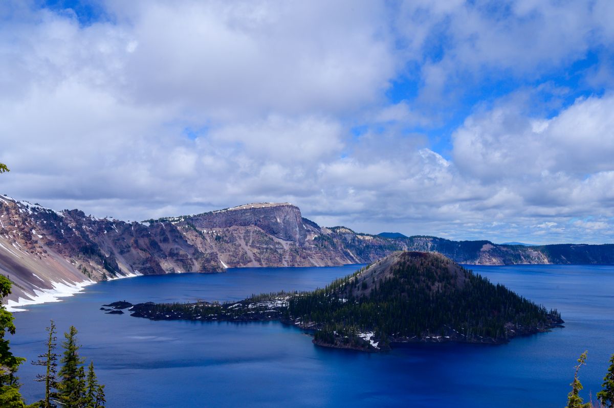

You will not believe the color of the water. You've seen photos. You've watched drone footage. You've read that Crater Lake is the deepest lake in the United States at 1,949 feet, that its clarity is measured in hundreds of feet, that the blue is a product of depth and purity, no rivers feed it, no sediment clouds it, just rain and snowmelt filtered through volcanic rock for seven thousand years. You've absorbed all of this intellectually, and then you stand on the rim and look down, and your brain refuses to process what your eyes are reporting.
The blue is not a color that exists in freshwater. It's the blue of deep ocean, of glacial ice, of something synthetic, except it's sitting in a volcanic crater at 6,178 feet in the Oregon Cascades, ringed by cliffs that drop a thousand feet to the surface. Wizard Island, a cinder cone that erupted from the caldera floor after the collapse, rises from the western basin like something from a myth. The water is so clear that submerged rocks are visible 100 feet down. The entire scene looks photoshopped, and you're about to hike down to the shore and cast a fly into it.
This is not a normal fishing trip. The fishing at Crater Lake is decent, rainbow trout and kokanee salmon, self-sustaining populations introduced over a century ago, catchable from the rocky shoreline at the bottom of a brutally steep trail. But nobody comes to Crater Lake for the fishing the way they go to the Deschutes or Yellowstone. You come because casting a Woolly Bugger into the deepest, clearest lake in America while standing on the inside of a collapsed volcano is an experience that exists nowhere else on Earth.
The Caldera, 7,700 Years in the Making
Crater Lake sits inside the caldera of Mount Mazama, a stratovolcano in the Cascade Range that stood roughly 12,000 feet tall before it destroyed itself approximately 7,700 years ago. The eruption was cataclysmic, 50 times more powerful than the 1980 eruption of Mount St. Helens. It ejected so much magma that the mountaintop collapsed inward, creating a basin more than five miles wide and over half a mile deep.
Rain and snowmelt filled the caldera over the next seven centuries. No rivers flow in. No rivers flow out. The lake is entirely self-contained, a closed hydrological system where precipitation equals evaporation and seepage. This isolation is the reason for the water's extraordinary clarity. There's no sediment input, no agricultural runoff, no upstream development. The water that fills Crater Lake has been filtered through porous volcanic rock, and it arrives in the basin essentially pure.
The result is visibility that defies comprehension. Secchi disk readings have measured clarity to 143 feet, you can see objects at the depth of a 14-story building. The blue color is a function of depth and purity: the water absorbs all wavelengths of light except blue, and the extraordinary depth means the blue is reflected back with an intensity that makes the lake look like a pool of liquid cobalt.
You're going to fish this water. It seems almost disrespectful, but the National Park Service wants you to.
The Fish, Non-Native and Unwanted
Here is the single most unusual thing about fishing Crater Lake: the park actively encourages you to catch and keep every fish you can. There are no catch limits. No size restrictions. No fishing license required. The National Park Service manages the fishery, not the state of Oregon, and their position is straightforward, the fish don't belong here, and the fewer of them there are, the better.
Crater Lake had no fish for its first 7,000 years. The lake formed behind sheer cliffs with no inlet streams connecting it to any watershed. No fish could reach it. The ecosystem evolved without them, a simple food web of phytoplankton, zooplankton, and aquatic insects.
William Steel, the man most responsible for Crater Lake becoming a national park, began stocking fish in 1888. Between 1888 and 1941, seven species were introduced: rainbow trout, brown trout, steelhead, coho salmon, Chinook salmon, kokanee salmon, and brook trout. Only two survived, rainbow trout and kokanee salmon (landlocked sockeye). The lake currently supports an estimated 60,000 fish between the two species.
Stocking ended in 1941 when the park recognized that introduced fish were altering the lake's natural ecology. The kokanee and rainbow trout compete with native invertebrates, change nutrient cycling, and represent a permanent deviation from the ecosystem that existed for millennia before Steel dropped the first fingerlings into the water. The park can't realistically remove 60,000 fish from a lake nearly two thousand feet deep, but they can encourage anglers to take as many as they want.
So they do. No license. No limits. Artificial lures only, no organic bait of any kind, including PowerBait, salmon eggs, or worms. You can fish from half an hour before sunrise to half an hour after sunset. And everything you catch, you're welcome to keep.
Getting to the Water, Cleetwood Trail
The Cleetwood Cove Trail is the only legal access to the lakeshore, and it earns every fish you catch. The trailhead sits on the north rim of the caldera, and the trail drops 700 feet in 1.1 miles to the boat dock and rocky shoreline at Cleetwood Cove. That's a gradient steep enough to make your knees file a formal complaint on the way down and your lungs lodge an appeal on the way back up.
The trail is a well-maintained but unrelenting descent through mountain hemlock and whitebark pine, switchbacking down the interior wall of the caldera. The footing is volcanic rock and packed dirt, not technical, but steep enough that you feel every pound of the fly rod, reel, and tackle you're carrying. Hiking boots or sturdy trail shoes are mandatory. Sandals and flip-flops are a recipe for an expensive helicopter evacuation.
The trail typically opens in late June or early July, depending on snowmelt, and closes in October when snow returns. The exact dates vary by year, check the park's website or call the visitor center before you make the drive. The park sits at over 7,000 feet on the rim, and winter here is no joke. The average annual snowfall is 43 feet. The road around the rim doesn't fully open until July most years.
Once you reach the bottom, you have roughly a quarter mile of rocky shoreline to fish. The rocks are volcanic, dark, angular, and slippery when wet. The water drops off fast. Within a few feet of shore, you're standing next to water that's 20, 50, 100 feet deep. The fish cruise this near-shore zone, feeding on the aquatic insects and zooplankton that concentrate along the rocky margins.
What to expect on the hike: The descent takes 20 to 30 minutes. The climb back up takes 45 minutes to an hour, and it's the kind of elevation gain that reminds you of every choice you've made that morning. Bring more water than you think you need. Start early, the afternoon sun on the south-facing trail turns the climb into a sauna. And remember: every piece of gear you carry down, you carry back up. Pack light.
Wizard Island, The Volcanic Bonus Round
Wizard Island is a cinder cone that erupted from the caldera floor after Mount Mazama's collapse, rising 763 feet above the lake surface. It sits in the western portion of the lake, accessible only by boat, and it offers some of the best shore fishing in the park.
The shoreline around Wizard Island is rockier and more varied than Cleetwood Cove, with points, coves, and submerged structure that concentrate fish. Rainbow trout cruise the drop-offs and rocky ledges, and the fishing pressure is lighter because reaching the island requires a boat tour ticket and the willingness to spend three hours on the island before the return boat arrives.
Important note for 2026-2027: The National Park Service is renovating the Cleetwood Cove trail and facilities. Boat tours, the only way to reach Wizard Island, are suspended for the 2026 and 2027 seasons. When tours resume, Wizard Island fishing will be available again, and it's worth the planning. The combination of a cinder cone hike and shoreline fishing in water this blue is something you won't find at Yellowstone, Glacier, or anywhere else in the park system.
When boat tours are operating in normal years, you take the boat from Cleetwood Cove dock to Wizard Island, where you can fish, swim, and hike the summit trail. The fishing is permitted from the shoreline and the island's dock (except when boats are approaching or docked). Three hours is enough time to hike the summit, fish for an hour, and catch the return boat, but you'll wish you had longer.
The Fly Box, Stillwater Patterns for Ultra-Clear Water
Crater Lake is stillwater fishing in its most visually intimidating form. The water is so clear that the fish can see you, your rod, your line, and your fly with a clarity that would make a Pennsylvania spring creek trout jealous. Long leaders, careful presentations, and flies that look like actual food are the requirements.
Rainbow Trout, The Primary Target
The rainbow trout in Crater Lake are descendants of fish stocked over a century ago. They've been wild for generations, no hatchery supplements since 1941, and they behave like wild fish. They're not large by Western standards (most run 8 to 14 inches, with occasional fish to 18), but they feed actively along the rocky shoreline and respond to well-presented flies.
Chironomids (Midges): This is the bread-and-butter pattern for Crater Lake. Midges are the most abundant aquatic insect in the lake, hatching throughout the ice-free season, and the trout key on them heavily. Zebra Midges (#16-20) in black, red, and olive are essential. Carry Chromie patterns, Ice Cream Cones, and Griffith's Gnats (#18-22) for surface clusters. A San Juan Worm (#14-16) in red or wine is another reliable subsurface option when the chironomid bite is slow. Fish chironomid pupae under a small indicator in the near-shore zone where the bottom drops away, the trout intercept ascending pupae in the water column, and a slowly sinking midge pattern is the most natural presentation you can offer.
Callibaetis: The stillwater mayfly. Callibaetis hatch on calm summer days, and when they're on the water, the trout rise for them with the kind of deliberate, confident feeding that makes dry-fly fishing worthwhile. Comparadun/Sparkle Duns (#14-16) in grey and tan match the duns. Parachute Adams (#14-16) is the reliable all-rounder. Callibaetis nymphs, slender, mottled, swimming patterns in #14-16, fished on a slow retrieve produce takes when the hatch is building but fish aren't yet on top.
Damselfly Nymphs: Damselflies are a major food source in Cascade lakes, and their nymphs, slender, olive, swimming with an undulating motion, drive trout wild. Fish olive or tan damsel nymph patterns (#10-12) on a slow, erratic retrieve along the rocky shoreline. The takes are often aggressive.
Scuds and Leeches: Scuds (#14-16, olive and tan) represent the freshwater shrimp that inhabit the rocky substrate. Small leech patterns (#8-10) in black, olive, and maroon, including balanced leeches fished under an indicator, are effective subsurface searching patterns when nothing specific is hatching. A black Woolly Bugger (#8-10) stripped along the rocky shore is the classic stillwater prospecting fly, and it works at Crater Lake for the same reason it works everywhere: it looks like something alive, and trout eat things that look alive.
Shore Fishing Specific: The rocky shoreline dictates the technique. You're standing on angular volcanic rocks, casting parallel to the shore or out into the drop-off. Woolly Buggers (#6-10) in black, olive, and brown, stripped with a slow, jerky retrieve, cover the most water. Small Clouser Minnows (#6-8) in olive-and-white or chartreuse-and-white, fished with a strip-pause retrieve along the rocky margins, imitate the small baitfish and sculpins the trout hunt. Muddler Minnows (#6-8), the original sculpin imitation, are another strong choice for the rocky near-shore zone.
Kokanee Salmon, The Other Player
Kokanee are landlocked sockeye salmon, and they make up the majority of Crater Lake's estimated 60,000-fish population. They're plankton feeders for most of their lives, cruising the open water and filtering zooplankton through their gill rakers, which makes them challenging to target on a fly.
When kokanee are near the shore, small, bright patterns can draw strikes. Tiny Woolly Buggers (#12-14) in red, orange, or pink. Small chironomid patterns in red or blood-red (#16-18). Kokanee jigs and small spoons are more traditional kokanee tackle, but on a fly rod, the bright-colored small patterns occasionally connect. Don't specifically target kokanee with a fly rod expecting consistent action, but if something hits your chironomid and fights differently from a rainbow, you've probably caught a kokanee.
The Gear
Rod: A 9-foot 5-weight is the right tool for Crater Lake. It handles the chironomid and Callibaetis patterns the trout eat, has enough backbone to cast Woolly Buggers and small Clousers along the shore, and is light enough to carry down (and back up) the Cleetwood Trail without cursing your gear choices. A 4-weight works if you're committed to dry flies and light nymphing. Don't bring anything heavier than a 6-weight, you're not fighting big fish, and the hike punishes unnecessary weight.
Line: Weight-forward floating line for most situations. An intermediate sinking line or a sinking leader system (like a Polyleader) lets you get chironomid patterns and leeches down in the water column along the drop-off. The fish often hold 10 to 20 feet below the surface, and a floating line with a long leader can struggle to reach them.
Leader: 9 to 12 feet, tapered to 5X or 6X fluorocarbon. The water clarity demands long leaders and fine tippet. Fluorocarbon sinks faster than nylon (helpful for subsurface patterns) and is less visible in clear water. For Woolly Bugger and streamer work, drop to 4X, you're stripping flies along rocks, and fine tippet invites break-offs on the sharp volcanic substrate.
Other essentials: Polarized sunglasses are critical, you want to see into the water, and the glare off Crater Lake's surface is intense. A small daypack with water, snacks, and sun protection. A landing net if you plan to release fish (the rocky shoreline makes hand-landing difficult). Felt-soled wading boots or approach shoes with good grip for the slippery rocks, you won't be wading (it's prohibited), but the shoreline is essentially wet volcanic rock and you need traction.
Annie Creek, Small Stream Fishing Inside the Park
If the Cleetwood Trail hike sounds too aggressive, or if you simply want to fish moving water, Annie Creek offers small-stream fly fishing without the caldera descent. Annie Creek runs through the southern portion of the park near the Mazama Village area, accessible from the park's south entrance road.
This is tiny water, a narrow mountain stream winding through meadows and conifer forest, holding small brook trout in the 6 to 10-inch range. The brook trout here are non-native (like everything in the park's waters), and the same no-license, no-limit regulations apply. The creek is dominated by small fish, and the fishing is never going to be confused with a destination experience, but if you have a 3-weight or 4-weight rod and an evening to kill, the setting is beautiful and the brook trout are willing.
The flies: Small attractor dries are the game on Annie Creek. Elk Hair Caddis (#14-18) in tan and olive. Parachute Adams (#14-18). Stimulators (#12-16) in yellow and orange. Royal Wulffs (#14-16). Anything bushy, visible, and roughly bug-shaped will draw strikes from brook trout in a stream this small. Subsurface, a #16 Pheasant Tail or Hare's Ear nymph dropped behind a dry fly covers the fish that aren't looking up. A Copper John (#16-18) or Prince Nymph (#14-16) is another reliable subsurface option in these small mountain freestones.
A note on Sun Creek: Sun Creek, another tributary stream within the park, is closed to fishing. It is critical habitat for federally threatened bull trout, the only fish species native to the park's watershed, and the park has invested decades of restoration work to recover the bull trout population from roughly 150 individuals to over 2,500. Respect the closure. The bull trout recovery at Sun Creek is one of the great conservation success stories in the National Park System.
When to Go
The fishing season at Crater Lake is dictated by snow, not by regulation. The Cleetwood Trail opens when it's snow-free (typically late June to early July) and closes when snow returns (October). The park's rim roads follow a similar schedule, the full Rim Drive circuit usually opens in July.
- Late June–Early July: Trail opens. Snow may linger on sections. The fishing is good, cold water temperatures keep the trout active, and chironomid hatches begin as the lake warms. Crowds are lighter before the Fourth of July.
- July–August: Peak season. The trail is fully clear, weather is warmest, and Callibaetis hatches bring fish to the surface on calm mornings and evenings. This is also peak tourist season, the parking area at Cleetwood Cove fills early, and you'll share the shoreline with swimmers and sightseers. Start early.
- September–October: The best fishing window if you can handle the uncertainty. Crowds thin dramatically. The trout feed aggressively as water temperatures drop, chironomid activity remains strong, and the fall light on the caldera walls is the kind of thing that makes photographers weep. The risk is weather, an early storm can close the trail with little warning. Check conditions before you drive.
Time of day matters. Morning and evening are best for active feeding. The midday sun illuminates the water so thoroughly that the trout can see your tippet, your shadow, and your intentions from 30 feet away. Fish the low-light hours, and spend midday on the rim admiring what is, without exaggeration, one of the most beautiful places on the planet.
The Reality Check
Let me be honest about the fishing, because the setting can create expectations the fish can't meet.
Crater Lake is not a great fishery. It is a good fishery in an extraordinary place. The trout are modest in size, most are under a foot, and a 16-inch rainbow is a genuinely good fish here. The kokanee are difficult to target on a fly. The access is limited to a quarter mile of rocky shoreline at the bottom of a steep trail (or Wizard Island when boats are running). You can't wade. You can't float. You can't bring a boat. You stand on volcanic rocks and cast into water that's deeper than any building you've ever been inside.
The anglers who love Crater Lake, and they exist, and they return every year, love it because the experience transcends the fishing. You are standing inside a volcano. The water beneath your fly line extends down nearly 2,000 feet. The silence on the shore, once the hikers clear out, is absolute, no road noise, no powerboats, no other anglers. Just the slap of wavelets on volcanic rock and the occasional rise form of a rainbow trout that has never seen a hatchery truck.
If you need 20-inch trout to justify carrying a fly rod down a 700-foot trail, fish the Deschutes instead, it's two hours north and it will deliver. If you need variety and world-class hatches, drive to Yellowstone. If you want another volcanic national park fishery with more consistent catch rates, try Grand Teton. But if you want to cast a fly into the deepest lake in America, in water so blue it looks like a special effect, in a caldera that was formed by one of the most violent volcanic events in North American history, Crater Lake is the only place on Earth that offers that experience.
No license required. No limits. The park wants you to keep the fish.
Bring a fly rod. Hike down. Cast into the blue.
Planning Your Trip
Crater Lake National Park is in southern Oregon, roughly 80 miles north of Klamath Falls and 175 miles south of Bend. The closest commercial airports are Rogue Valley International-Medford (MFR, 85 miles) and Crater Lake-Klamath Regional (LMT, 60 miles). From Portland, it's a five-hour drive south on I-5 and Highway 62.
The park has two entrances: the south entrance (open year-round, though winter access is limited) and the north entrance on Highway 138 (open seasonally, typically June through October). Mazama Village, just inside the south entrance, has a campground, a general store, and the Annie Creek Restaurant. Crater Lake Lodge, perched on the rim with views that justify whatever they charge per night, books months in advance for the summer season.
Klamath Falls is the nearest full-service town, with lodging, restaurants, tackle shops, and fishing guide services. The Klamath Basin is excellent fishing country in its own right, the Upper Klamath Lake, Williamson River, and Wood River offer blue-ribbon trout fishing that pairs perfectly with a Crater Lake visit. A long weekend itinerary that combines a day at Crater Lake with two days on the Klamath Basin rivers is one of the best fishing trips in Oregon.
For anglers exploring the broader Cascade Range, the Lower Deschutes is a three-hour drive north and offers the world-class river fishing that Crater Lake can't. North Cascades National Park in Washington and Yosemite and Sequoia-Kings Canyon in California offer similar high-altitude national park fishing experiences, though none of them can match Crater Lake's sheer visual impact. For a completely different national park experience in the Pacific Northwest, Olympic National Park offers rainforest rivers and wild steelhead on the opposite end of the fishing spectrum.
The Klamath Basin's rivers, the Williamson, the Wood, and the Sprague, reward anglers who build a trip around them, and pairing a day inside the caldera with the region's blue-ribbon trout water makes for one of the best long weekends in southern Oregon.