Fish
Fish Fire
Fire Hike
Hike Bird
Bird

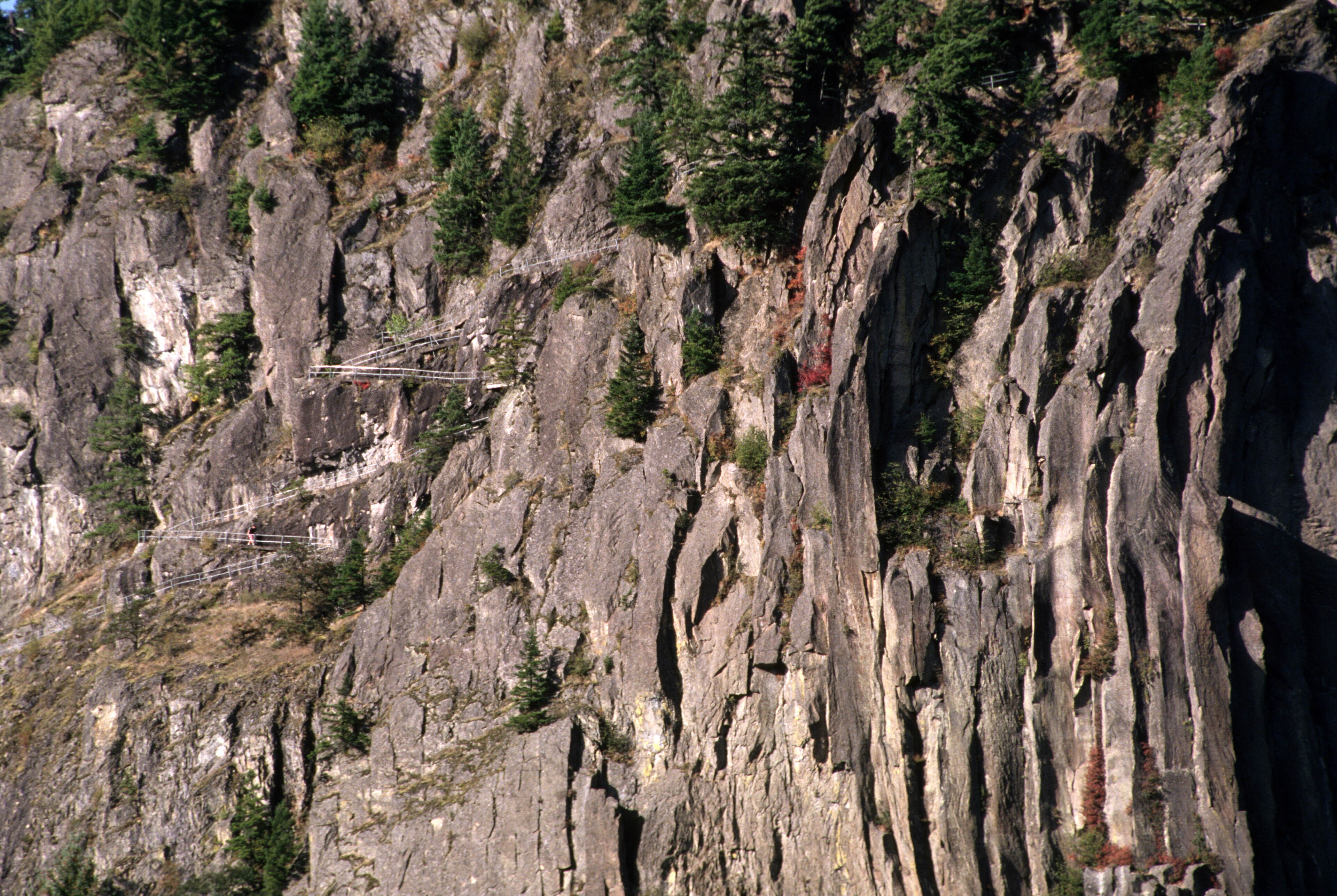

Beacon Rock stands 848 feet straight out of the north bank of the Columbia River, an isolated column of basalt with sheer sides on every aspect.
A trail goes up it. That trail exists because of one man's stubbornness, and it is one of the more remarkable pieces of amateur engineering in the American West.
What the rock is
It is a volcanic plug, the solidified conduit of a volcano whose softer outer cone has entirely eroded away, leaving the hard core standing alone. It is roughly 57,000 years old, and it survived because it was tough enough to withstand the Missoula Floods, which repeatedly tore down the Columbia Gorge and stripped everything less resistant, scouring the rock's flanks bare, which is why it stands so abruptly out of the river.
Lewis and Clark named it in 1805, and their journals record the tidal influence beginning here, which told them they were nearing the Pacific. It was called Castle Rock for much of the nineteenth century before the original name was restored.
Henry Biddle's trail
In the early twentieth century the rock was slated for demolition, with a plan to quarry it for jetty stone for the mouth of the Columbia. Henry J. Biddle, a Portland businessman and amateur geologist, bought the rock in 1915 specifically to stop that happening.
He then decided to build a trail to the top, which every reasonable assessment said was impossible on a rock with vertical faces on all sides. Working with Charles Johnson, Biddle began construction in October 1915 and finished in April 1918, paying for it himself at a personal cost of about $10,000, which was a serious sum.
What they built runs 4,500 feet, is four feet wide, holds a maximum grade of 15 percent, and includes 52 switchbacks, 22 bridges and over a hundred concrete slabs spanning gaps in the cliffs, with much of it a catwalk bolted and cantilevered to the rock face.
After Biddle died in 1928, his heirs tried to give the rock to Washington State, which declined it. When Oregon's parks superintendent moved to acquire it, Washington reconsidered rather than let a neighboring state own a landmark on its side of the river. It became a state park in 1935.
Climbing it
The trail is about 1.8 miles round trip with roughly 600 to 650 feet of gain, and it takes most people around an hour and a half. It is not hard in the athletic sense, because the grade is gentle by design, since Biddle built it to be walkable rather than scrambled.
What it is, is exposed. You are on a four-foot catwalk with a railing, with air below you and the Columbia several hundred feet down, switchbacking up a cliff, so people with a fear of heights find it difficult and it is worth knowing that before you commit.
The handrails are continuous and the surface is good, and children do it routinely. It is not a place to pass carelessly, because the switchbacks are tight and the trail is one-way-wide in places. The summit view runs up and down the Gorge, with Bonneville Dam downstream and the walls rising on both sides. And the trail closes in ice, which makes it dangerous when frozen.
The rest of the park is bigger than the rock
Most visitors climb Beacon Rock, drive away, and miss the better hiking, which is on the north side of the highway. Hamilton Mountain is the main event at roughly 7.5 to 8 miles round trip with about 2,100 feet of gain, climbing past Hardy Falls and Rodney Falls and the Pool of the Winds, a rock chamber where the falls blasts through a slot and generates a permanent gale, with the summit giving one of the best Gorge views on the Washington side.
The Pool of the Winds alone is worth the walk, about 2.5 miles round trip, and it is one of the stranger places in the Gorge. Hardy Ridge offers a longer, quieter loop with less traffic, and the Doetsch Ranch area on the river flats gives easy flat walking and river access. The park holds around 4,500 acres in total, and the rock is a very small part of it.
The Gorge, and how it got here
Beacon Rock makes more sense once you know what the Columbia River Gorge is. It is the only sea-level route through the Cascade Range, a water gap eighty miles long and in places four thousand feet deep, cut by the river as the mountains rose around it, because the Columbia is older than the Cascades and it kept cutting as they lifted. The Missoula Floods then repeatedly scoured it, stripping soil, plucking away weaker rock and steepening the walls into the near-vertical cliffs you see, and Beacon Rock survived because it is the hard core of a volcano while almost everything softer around it was removed.
The Gorge is also a climatic boundary, because marine air funnels east through the gap and continental air funnels west, and the transition from temperate rainforest to sagebrush happens over a distance you can drive in under an hour. That gradient is why the wind is so reliable and why the flora changes so fast.
It has been a National Scenic Area since 1986, a designation that mixes federal, state and county management with land-use rules on private ground, and it is the reason the Gorge has not been developed the way similar landscapes near cities usually are.
Wildflowers, which are the other reason to come
The Gorge is one of the best wildflower regions in the Pacific Northwest, and the Washington side holds a lot of it. Beacon Rock itself supports species adapted to thin soil on vertical basalt, and the trail passes them at eye level, which is unusual. Hamilton Mountain's upper meadows carry balsamroot, lupine and paintbrush, and the peak is April into May at low elevation, extending into June higher up.
The Gorge also holds a set of endemic species found nowhere else, including the Columbia Gorge daisy and several others restricted to specific cliff bands, a consequence of the area's isolated microhabitats and its history as an ice-age refuge. The eastern Gorge, thirty miles upriver, is drier and has an entirely different and equally famous display.
The Beacon Rock Trail, Beacon Rock State ParkSalmon, and the river below
The Columbia beneath Beacon Rock is one of the great salmon rivers of the world, or was. Historically the river supported runs estimated at ten to sixteen million adult salmon and steelhead a year, across multiple species and dozens of distinct populations, returning to spawning grounds as far inland as Idaho and British Columbia.
Bonneville Dam, immediately downstream of Beacon Rock, was completed in 1938 as the first federal dam on the lower Columbia, and many more followed. The dams generate a large share of the region's electricity and made the river navigable far inland, and they also blocked or degraded passage, changed water temperature and flow timing, and drowned spawning habitat, including Celilo Falls, an Indigenous fishing site used continuously for thousands of years, which was inundated in 1957. Runs today are a fraction of historical numbers, with many populations listed under the Endangered Species Act.
At Bonneville you can watch salmon climbing the fish ladders through underwater viewing windows, which is a worthwhile stop ten minutes from Beacon Rock and gives the river below the rock a different meaning. Sea lions have followed the salmon upriver to the dam, which has created its own contentious management problem.
The gear
Beacon Rock is a mile of switchbacks and catwalks bolted to the side of a volcanic plug, and the list is short and specific.
A head for heights, which is the qualifying item. The trail is safe, railed and well maintained, and it also consists of fifty-odd switchbacks on steel and concrete catwalks with air underneath them. People with a real fear of exposure turn around partway, and that is a reasonable thing to find out before driving there.
A wind layer, because the top is a bare summit in the Columbia Gorge, which is one of the windiest corridors in the country by design: it is the only sea-level gap through the Cascades and the pressure difference between the wet and dry sides drives air through it constantly.
Traction devices in winter, since the catwalks ice and the trail is closed or unpleasant when they do.
A Discover Pass for the lot.
Poison oak wash, because it is abundant on the sunny lower slopes here and along the Hamilton Mountain trail across the highway.
A short leash, on a trail where there is nowhere to step aside.
And more time than the rock needs, since the park's other trails, particularly Hamilton Mountain, are the better hiking and most visitors never leave the rock.
Season
Spring is best for the waterfalls on the Hamilton Mountain trail, which run hardest March through May, and for the flowers. Summer is busy and hot on the exposed rock and the falls diminish, autumn is excellent and quieter, and winter is the risk period, because the Beacon Rock trail ices and closes and the Gorge's east wind can make the exposure unpleasant.
The Gorge wind is a constant here in any season. This corridor is a wind tunnel between the wet west and the dry east, which is why the windsurfing near Hood River is world famous, and why the summit of Beacon Rock is rarely still.
Beacon Rock State Park: Things to Do, Hiking and CampingWhere else to go in the Gorge
The Washington side is the quieter half and it holds more than Beacon Rock. Cape Horn is a loop of roughly seven miles with big views over the western Gorge, Dog Mountain is the famous wildflower climb at about seven miles with 2,800 feet, Table Mountain is the hard one on a long steep day from the Bonneville area, and Coyote Wall and Catherine Creek in the drier eastern Gorge offer open oak and grassland walking with a different and equally good spring flower display, excellent when the west end is under cloud. The Pacific Crest Trail crosses the Columbia at the Bridge of the Gods just downstream, which is the lowest point on the entire trail at around 140 feet above sea level.
Three of those carry seasonal access rules that catch people out, and they are all different. Rock climbing on Beacon Rock's south face closes from February through mid-July to protect nesting peregrine falcons, Cape Horn's lower section closes on a similar schedule for the same reason, and Dog Mountain requires a permit on spring weekends because the balsamroot display draws enormous crowds. Three sites within half an hour, three different rules, each active for part of the year. Guidepole Hike carries seasonal closures and permit requirements against each trailhead, which in a corridor managed jointly by federal, state and county agencies is more reliable than assuming the Gorge has one rule.
The Oregon side has the famous waterfalls, and much of it was burned in the 2017 Eagle Creek fire with trail closures that took years to resolve.
Practical notes, and what to do with a day
A Discover Pass is required for parking, at $10 a day or $45 a year. Camping is available and books nine months ahead. Dogs are welcome on an eight-foot leash, though the Beacon Rock trail with its catwalks and drop-offs is a poor place for a dog that pulls. It is about 45 minutes east of Vancouver, Washington, and an hour from Portland, and parking at the rock fills on summer weekends with limited pullouts on Highway 14. Poison oak is present on the lower slopes.
For the day: climb the rock first, early, before the parking fills, which takes an hour and a half. Then cross the highway and walk to the Pool of the Winds, which most people never see. And continue to Hamilton Mountain if you have the legs, for 2,100 feet and the best view on this side of the river.
On the way up the catwalk, look at what is holding you: concrete poured onto a cliff face in 1916 by two men working with hand tools and a rope, because one of them did not want a rock blown up.
The Oregon side of the Gorge is in the Multnomah and Wahkeena loop and hiking Portland. Washington's other state park highlights are Deception Pass and Dry Falls, and the pass system is in six states, six ways to charge you for a trailhead.
The Oregon side of the same gorge is in the Multnomah and Wahkeena loop and hiking Portland. The volcano upstream is in the Timberline Trail on Mount Hood. The Washington pass required here is in state park passes by state, and the dry end of the same state is in Dry Falls.
One more thing about the rock itself, since the trail is as remarkable as the view. Henry Biddle bought Beacon Rock in 1915 for one dollar, specifically to stop the Army Corps of Engineers blasting it for jetty rock, and then spent three years building the trail up it with his own money. The switchbacks, handrails and catwalks you are walking on are substantially his, completed in 1918. His heirs later tried to give the rock to Washington, which declined it, and it became a state park in 1935 only after Oregon's parks superintendent moved to acquire it and Washington reconsidered.