Fish
Fish Fire
Fire Hike
Hike Bird
Bird

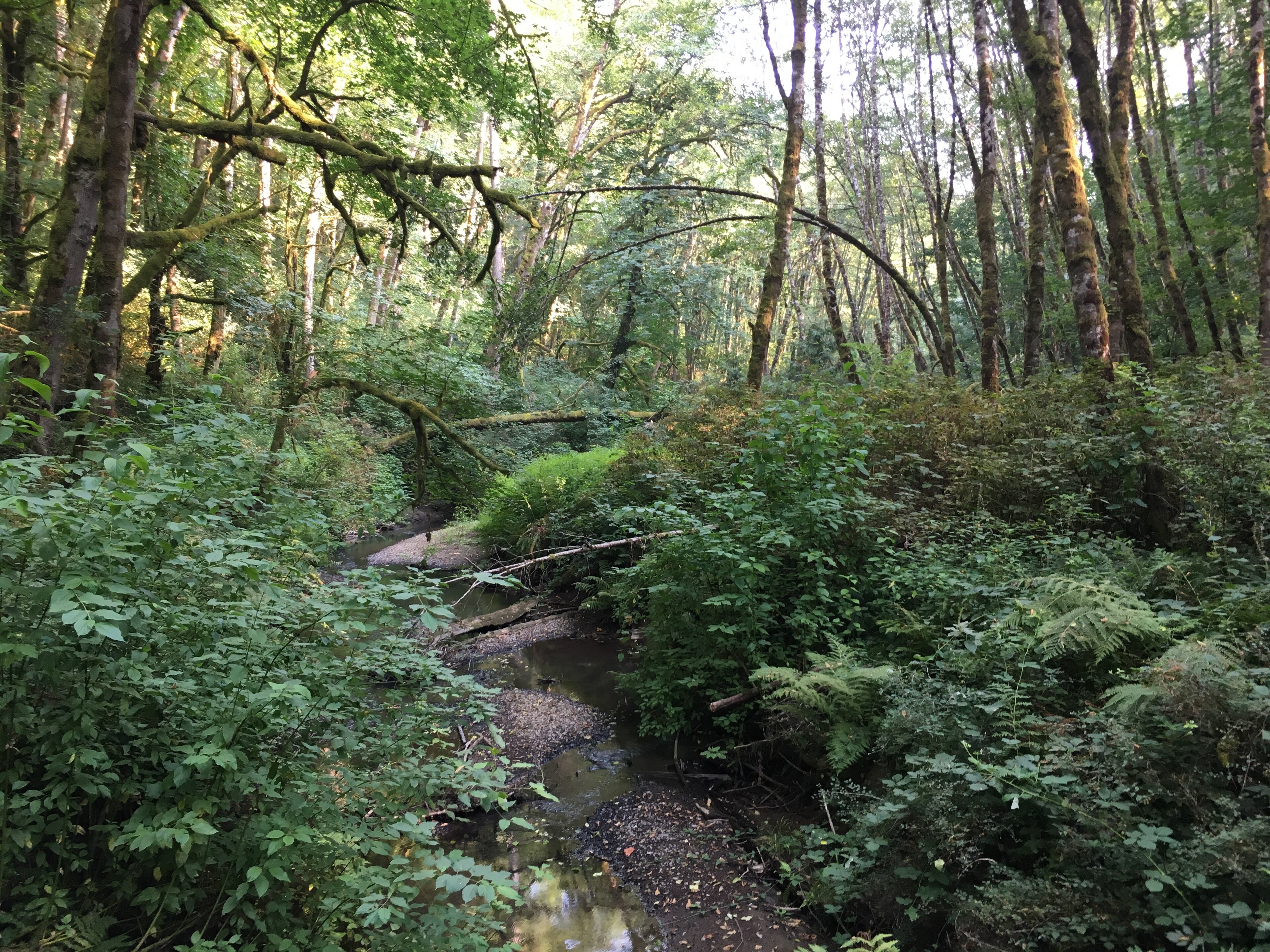

Portland has a genuine state park inside the city limits, which very few American cities can say.
Tryon Creek State Natural Area covers about 670 acres of second-growth forest in a steep ravine between southwest Portland and Lake Oswego, with roughly eight miles of trail and a creek that still supports salmon.
It is a fifteen-minute drive from downtown, and on a wet Tuesday in February you can walk for an hour and see three people.
It was nearly a subdivision
The park exists because of a specific, short, successful campaign. The land had been logged in the nineteenth century to fuel an iron smelter in Lake Oswego, then left to regrow, and by 1970 it was privately held and slated for residential development.
A group of neighbors formed the Friends of Tryon Creek and mounted a campaign to buy it. They had months rather than years, and they raised money locally, lobbied the state and Multnomah County, and assembled the purchase. Oregon acquired it and it opened as a state park in 1975 as one of Oregon's first State Natural Areas, and the Friends group still co-manages the nature center and the education programs half a century later.
That origin explains the park's character. It is a neighborhood asset that happens to be run by the state, and it feels like it.
The trillium
If you go once, go in late March or early April. Trillium ovatum, the western trillium, carpets the forest floor here in early spring and the display is locally famous, with the park running a Trillium Festival around the peak bloom that has been an annual event for decades.
Trillium is worth understanding because it explains something about old forest. The plant takes years to reach flowering size from seed, spreads slowly, and is extremely sensitive to disturbance, and picking the flower can kill the plant outright, because the three leaves below it are the plant's entire photosynthetic apparatus for the year.
A dense trillium display is therefore a sign of ground that has been left alone for a long time, which in a city is not nothing. Other spring ephemerals follow: fringecup, bleeding heart, oxalis, and skunk cabbage in the wet bottoms.
The trails
About eight miles, all of it in the ravine, none of it long. The Trillium Trail is a paved accessible loop of about a third of a mile near the nature center, the Middle Creek Trail and Red Fox Trail drop into the ravine and cross the creek on footbridges, the Old Main Trail runs the length of the park, the Cedar Trail and Big Fir Trail climb the sides, and the North Horse Loop is the longest circuit and gives you the most distance. A paved bike path runs along the eastern edge and connects toward Lake Oswego.
A full circuit of everything is perhaps four or five miles with a few hundred feet of cumulative climbing, and because the ravine is steep-sided the walking is more up and down than the map suggests.
The rules here follow from the designation rather than from the fact that it is a park, and they are not the rules of the state park you drove past on the way. Dogs are allowed on leash, which is not always true of natural areas, and is the kind of rule an agency revisits, so check the Oregon State Parks page for this site if you are bringing one. Bikes are restricted to the specific paved path rather than the trail network, horses have their own dedicated trails, and staying on trail is expected, because the whole point of the designation is protecting a forest and stream system inside a city where the surrounding land is developed. There is no camping and no swimming, and it is day use only, closing at dusk. Guidepole Hike carries the designation and its rules against the trail, which around Portland matters because state park, state natural area and city park sit within a few miles of each other and permit noticeably different things.
The creek and the salmon
Tryon Creek runs the length of the park and into the Willamette, and it supports cutthroat trout and a small run of coho salmon and steelhead. That is remarkable for an urban creek and it is fragile, because the catchment is largely developed, so the creek takes the full force of road runoff and stormwater surges after rain. A long-running effort has been made to improve fish passage, including work on the culvert where the creek passes under Highway 43 downstream, which was a barrier for decades.
Do not walk in the creek, because spawning gravel is easy to destroy and hard to replace. Beaver are present and their dams reshape the lower reaches periodically. And the forest around it is second-growth Douglas fir, western red cedar and bigleaf maple, with a dense understory of sword fern, salmonberry and Oregon grape, which makes it a good example of what Willamette Valley forest looks like eighty years after logging.
The iron, and why the forest is young
The reason Tryon Creek is second growth rather than old growth is a smelter. Lake Oswego, immediately south, was an iron town, where the Oregon Iron Company built a furnace in 1866, the first iron smelter on the Pacific coast, and operated it in various forms for decades.
Smelting iron with charcoal consumes wood on an industrial scale, so the forests around the works, including the Tryon Creek ravine, were cut to feed it. The furnace chimney still stands in Lake Oswego as a public monument, and the ravine's forest is what grew back after the cutting stopped.
That history is why the trees are roughly a century old rather than five hundred, why the understory is dense, and why the trillium display, which needs long-undisturbed ground, is a meaningful indicator that this particular ravine has been left alone since.
What lives in the ravine
For a park this size, inside a city, the wildlife is better than it has any right to be. Northern flying squirrels, little brown bats and other bat species, and coyotes all use the park, though mostly at hours when nobody sees them. Barred owls are now common, having expanded across the Pacific Northwest over recent decades, largely at the expense of the northern spotted owl, and pileated woodpeckers work the dead standing timber and are hard to miss. Black-tailed deer move through the ravine.
Down in the wet bottoms, rough-skinned newts and Pacific chorus frogs breed, and the newts are worth knowing about, because their skin carries tetrodotoxin, the same compound found in pufferfish, in quantities that make them dangerous to eat and harmless to look at. Salmonberry, thimbleberry and red huckleberry fruit through summer.
The park's value as a wildlife corridor is disproportionate to its size, because it connects fragmented habitat across a developed area rather than sitting isolated.
Exploring Tryon Creek State Natural AreaGoing with children, or without much mobility
This is one of the better parks in Oregon for both, and it is worth being specific. The Trillium Trail is paved, about a third of a mile, with a gentle grade and benches, and it is designed for wheelchairs and strollers rather than nominally accessible, passing through good forest and reaching the trillium display in season.
The nature center has toilets, indoor space, exhibits aimed at children, and staff who run programs. Distances are short, and no point in the park is far from a road or the center, which removes the usual anxiety about turning a family walk around. The bridges over the creek are a reliable hit with small children.
The gradient is the one caveat, because the ravine is steep-sided and once you leave the paved loop the trails climb and descend properly. And while the main lot now charges a $10 day-use parking permit, walking, biking or arriving by transit remains free, which for a family visiting repeatedly through a winter keeps the barrier low.
For a park that exists at all only because neighbors fought for it in 1970, being usable by the widest range of people feels like the right outcome.
The gear
Tryon Creek is the smallest and gentlest park in this group, and the gear list is honest about that.
Waterproof footwear, because the trails here are ravine bottom and they are mud from October through May.
A rain shell, for the same nine-month reason as everywhere else in the Willamette Valley.
A leash, since Oregon State Parks require one and this park in particular is heavily used by neighbors walking dogs.
A wildflower guide, which is the genuine reason to come in March and April. The trillium bloom here is the best in the Portland area and the park runs an annual festival around it.
A transit app, because Tryon Creek is inside the metropolitan area and reaching it without a car is realistic, which is not true of most of the parks in this library.
Nothing else, and that is the point. This is a five-mile network of soft-surface trails in a ravine with a nature center at the top. It does not need boots, poles, a filter or a permit, and treating it as though it does is missing what it is for.
And restraint about the creek, which is the one rule that matters. Tryon Creek supports a small run of cutthroat trout and the banks are actively being restored, so staying out of the water is the whole ask.
Season, and the practicalities
Early spring is the best, for the trillium, hands down. Winter is excellent walking, because the park drains reasonably, the crowds vanish, and the bare canopy opens up the ravine. Autumn brings bigleaf maple color, which in a wet Oregon forest is more striking than people expect, and summer is green, cool under canopy, and the busiest. The park is usable in rain, which in Portland is the whole point, because this is a place people walk in weather rather than despite it.
Two honest caveats attach to that. Peak trillium weekends in early April bring very large numbers, and the festival weekend in particular fills the parking lot and the main trails, so go midweek during the bloom or early in the morning. And deep winter after prolonged rain turns the lower ravine trails to genuine mud, with the park asking people to stay off certain sections when they are saturated to prevent tread damage, though the paved loop stays usable. Mud is the defining feature from November through April, because this is a ravine in western Oregon.
As of October 2025 the main lot charges a $10 day-use parking permit, one of 22 Oregon state parks where a fee was added, though walking, biking or arriving by transit is free. The nature center has toilets, exhibits and staff. It is about fifteen minutes from downtown Portland off Terwilliger Boulevard, and TriMet serves the area, so the park is reachable without a car.
Grant's Getaways: Why I Love Tryon CreekPortland's wider green network
Tryon Creek is one piece of an unusually good urban natural-area system, and knowing the others helps. Forest Park is the big one, at over 5,000 acres along the west hills with the 30-mile Wildwood Trail running its length, and it is among the largest urban forest reserves in the United States. Powell Butte is an extinct volcanic cone in southeast Portland with open meadows and long views to the Cascades, and Mount Tabor is another cinder cone inside the city, with reservoirs and a road closed to cars on Wednesdays.
Oaks Bottom Wildlife Refuge sits on the Willamette floodplain and is the city's best birding, while Smith and Bybee Wetlands in north Portland is one of the largest protected urban wetlands in the country. The 40-Mile Loop, conceived in 1904 and now far longer than forty miles, is the trail and greenway system intended to link all of it.
What distinguishes Tryon Creek within that group is that it is the only state-managed unit, that it protects a complete small watershed rather than a hillside or a butte, and that it has an accessible paved loop through the best of it.
Why it matters more than its size
Six hundred and seventy acres is not large, and Forest Park across town is more than seven times bigger.
What Tryon Creek offers is different: a complete small watershed inside a city, with a functioning stream, a salmon run, an intact forest floor, and an accessible paved loop that lets people who cannot manage rough trail see it properly.
And it exists because a group of neighbors in 1970 found out what was about to happen and had a few months to stop it. Most such campaigns fail. This one did not, and the result is a state park you can reach by bus.
Portland's larger forest is covered in hiking Portland, the Gorge is in the Multnomah and Wahkeena loop, and Oregon's other state parks are Silver Falls, Smith Rock and Fort Stevens. What a natural area designation means is in natural area, scenic trail, reserve.
The city's larger forest is in hiking Portland, and the gorge an hour east is in the Multnomah and Wahkeena loop and Beacon Rock. The birding version of the same city is in birding Portland. What a state natural area designation means, and why it is not a park, is explained in state natural areas explained.