Fish
Fish Fire
Fire Hike
Hike Bird
Bird


Most refuges tell you when to visit. Billy Frank Jr. Nisqually National Wildlife Refuge tells you something considerably more useful: which tide height produces which birds.
That is unusual, it is specific, and it is the single thing that determines whether your morning here works.
The tide table is the trip plan
The refuge sits at the mouth of the Nisqually River where it enters Puget Sound, and the estuary in front of you is entirely reshaped twice a day. The published guidance is worth committing to memory:
-
10 feet or less: exposed mud. This is the shorebird and heron tide, with Great Blue Herons scattered across the flats, peeps working the edge, and the largest area of feeding habitat available.
-
10 to 11 feet: good for dabbling ducks, as the shallow water spreads over the marsh.
-
11 to 13 feet: diving ducks and seabirds, as the channels fill and the deeper water comes closer in.
-
Over 13 feet: best for diving birds, with the flats gone entirely and the birds pushed in close.
There is no bad tide here. There is a tide that suits what you came for and one that does not, and the mistake is arriving without having looked. If you want shorebirds, come on a low tide; if you want scoters, goldeneye and grebes at close range, come on a high one. If you can manage it, come on a rising or falling tide and get both.
The Billy Frank Jr. Nisqually National Wildlife Refuge Estuary BoardwalkThe trails, the hours, and the three-dollar question
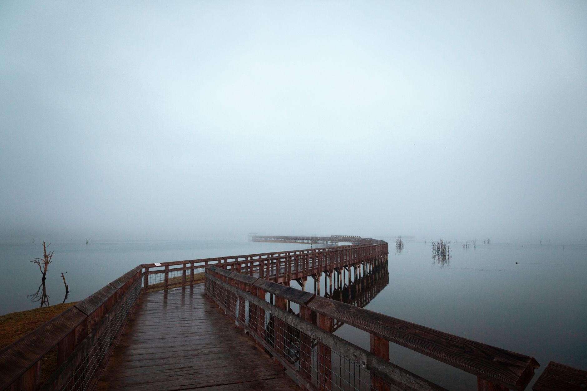
There are roughly four miles of flat boardwalk and gravel path, and two routes that matter. The Twin Barns Loop Trail is a one-mile loop, mostly boardwalk, through permanent freshwater wetland and riparian woodland; it is the passerine, woodpecker and marsh-bird walk, and it is fully accessible. The Nisqually Estuary Boardwalk is the headline, a four-mile round trip running out over the estuary to a viewing platform well out in the tidal marsh, with Mount Rainier behind you and the Olympic Mountains across the water on a clear day, which is a great deal of scenery for a flat walk.
The refuge suggests a visit averages about two hours. That is about right for the loop and comfortably short for anyone intending to walk the estuary boardwalk properly with a scope.
The grounds are open sunrise to sunset year-round. The Norm Dicks Visitor Center opens Wednesday to Sunday, 9am to 4pm, excluding federal holidays, and the administrative office runs Monday to Friday on the same hours. Entry costs $3.00 per vehicle, with children under 16 free, and the kiosk takes cash or checks only, which catches out a great many visitors who have not carried cash since about 2019.
The part worth knowing is that an America the Beautiful pass or a Federal Duck Stamp gets you in free. The duck stamp is the interesting case, because it costs considerably more than three dollars but admits you free to fee-charging national wildlife refuges nationwide for a year, and roughly all of the money goes to buying and protecting wetland habitat. If you visit refuges more than a handful of times a year it is both the cheaper option and the one that funds the ground you are standing on.
Nisqually Wildlife Refuge: Olympia's Best-Kept SecretWhat the dike removal did
The estuary in front of you is younger than most of the birders standing on the boardwalk, and that is the most interesting thing about the site. For most of the twentieth century this was diked farmland, with a sea wall built in the early 1900s cutting the delta off from the tide and the land behind it drained and farmed, which is the same story as almost every estuary on the Pacific coast.
In 2009 the refuge removed the dike and let the tide back in, restoring several hundred acres of the delta to tidal marsh in one of the largest estuary restoration projects in the Pacific Northwest. What followed is the part worth knowing. Salt marsh vegetation re-established faster than predicted. Channels re-cut themselves along their historic lines. Juvenile salmon began using the restored marsh as rearing habitat within the first seasons, which was the primary purpose. And the bird community shifted from a freshwater farmland assemblage to an estuarine one.
So when you look out from the boardwalk platform you are looking at a deliberate, recent and largely successful reversal of the default direction of travel for American wetlands, which is rare enough to be worth registering rather than walking past. It also explains the layout, because the Twin Barns loop runs through the freshwater wetland sitting behind the restored area, which is why two trails produce such different birds over such a short distance.
Who the refuge is named for
This is not decoration. Billy Frank Jr. was a Nisqually tribal leader arrested repeatedly, by his own count around fifty times, for fishing the Nisqually River in the exercise of treaty rights that the state of Washington spent decades refusing to recognize. The fish-ins he led were central to the litigation that produced the Boldt Decision in 1974, which affirmed treaty tribes' right to half the harvestable salmon and their standing as co-managers of the resource. The refuge was renamed for him in 2015, the year after his death.
So when you walk out over an estuary that was diked and farmed for most of the twentieth century and has since been returned to tidal marsh, the name on the sign is a reminder that access, ownership and who gets to decide are the oldest questions on this river rather than new ones.
What you will see
Winter is the strongest season and the reason most birders come, with large numbers of waterfowl on the estuary and the sound including scoters, goldeneye, bufflehead, wigeon and pintail, Northern Harrier and Bald Eagle over the marsh, Peregrine Falcon working the flats, and a good chance of Short-eared Owl at dusk in the right winters.
Spring and autumn migration bring shorebirds to the flats, best on a low tide, with Western and Least Sandpiper, Dunlin, dowitchers and Greater Yellowlegs the regulars plus scarcer birds for anyone who looks properly. Summer is the quietest for numbers but good for breeding marsh birds, swallows over the sloughs and the freshwater wetland species on the Twin Barns loop. And year-round the woodland edges hold the standard western Washington set, with the Twin Barns loop a reliable place for woodpeckers.
The gear
Nisqually is a small refuge that rewards precise timing, and the most important item on this list is a piece of information rather than a thing.
A tide table checked before you leave, because the boardwalk over the estuary is either the best birding in south Puget Sound or an empty expanse of water, and the difference is two hours. You want a falling tide that exposes the mud while you are out there, not a high slack.
Three dollars in cash for the entrance fee, or a Federal Duck Stamp, which covers it and which is worth buying anyway since the money goes to habitat acquisition.
A spotting scope, since the estuary is wide and the shorebirds and waterfowl are out on it.
Wind-proof layers, because the boardwalk is a mile of exposed structure over open water and there is nothing between you and the wind coming up the sound.
Waterproof footwear for the inland trails, which stay wet through the winter.
Binoculars with good low-light performance, since the productive hours here are early and late and the Northwest winter light is not generous.
And patience for the estuary platform, which is the actual technique. The birds move with the water, the flats fill and empty over a couple of hours, and standing in one place watching that happen produces far more than walking the boardwalk twice.
Reading the estuary at a glance
A short field habit makes the platform far more productive. Scan the water line first, because that is where the birds concentrate whatever the tide is doing: on a falling tide the line moves away from you and the feeding birds follow it, and on a rising tide it comes to you and so do they. Check the channel edges rather than the middle, since dabbling ducks, herons and shorebirds work the margins where the depth suits them while the open middle of a filled channel is usually empty.
Look at the snags and the old pilings, because Bald Eagle, Great Blue Heron and Peregrine all use fixed perches and the same perch gets used day after day. Watch the marsh surface for movement rather than shape, since rails, bitterns and sparrows in the salt marsh are almost never seen as outlines but as a stem that moves against the wind. And when everything goes up, find the raptor, because a mass flush on this estuary has a cause and identifying it is usually more interesting than the birds that flushed.
The neighboring sites
Nisqually is worth a full morning, and two additions make it a day. Luhr Beach and the Nisqually Reach sit just west, reached from a separate road, giving a different angle onto the delta with a boat launch and a view over the reach, and this is often the better vantage for scoters, loons and grebes on the water, particularly on a high tide when the refuge birds are pushed out. Tolmie State Park, a short drive further, adds a Puget Sound shoreline with a different set of nearshore species and a good chance at Marbled Murrelet in season. And the Nisqually Valley upstream holds farmland with wintering swans, raptors and in some winters large flocks of geese, though most of it is private and viewing is from the road.
The useful pattern is to work the refuge on the falling tide, then move to Luhr Beach or the reach when the water comes up. That way you get the flats and the open water in one trip, which the refuge alone will not give you.
A first visit
Check the tide before you check the weather, and aim to arrive on a falling tide so the flats emerge while you are there. Bring three dollars in cash or a Duck Stamp. Walk the Twin Barns loop first while the light is low, then take the estuary boardwalk out and give the platform half an hour with a scope.
Dress for standing still rather than for walking, because the boardwalk is four miles of round trip over open estuary with no shelter and the wind comes straight off the water. The ground is flat and largely accessible, which makes this one of the better options in the region for birders with limited mobility. Dogs are not permitted on refuge trails, as at most national wildlife refuges, which surprises people arriving from a state park where they were. And bring a scope, because much of the estuary viewing is at range and on a high tide the birds are out on the water rather than in front of you.
Nisqually is the friendly case for a map: well signed, clearly bounded, with the tide guidance published. The value of ownership data here shows up in the ground around it, where the refuge boundary meets Nisqually Reach, the tribal reservation, state land and private property, and where the distinction is not obvious from a trailhead. It also shows up in the thing this refuge teaches better than most, which is that timing is an access question, because a mudflat is only available to you at certain hours and a map that knows what is walkable at low water is more useful than one that draws a green polygon.
Then look up for the Peregrine, because something will put the shorebirds up eventually and it is usually worth finding out what. The estuary supports several through the winter, hunting the flats from height, and the flush they produce is unmistakable once you have seen it: not the loose ragged lift a passing eagle causes, but every bird on the mud going up at once and staying up, wheeling in a tight ball until the falcon commits or leaves.
For the wider skill, shorebirding is a tide problem covers why this works, and a wildlife refuge is not a park explains the duck stamp and the rules that come with the refuge sign.
The tide-driven logic of this place is the general case described in shorebirds and tides. The nearest city birding is in birding Seattle, and the winter goose and swan spectacle an hour and a half north is in Skagit flats snow geese and where to see trumpeter swans. Why a refuge charges a fee, closes at dusk and manages its trails the way it does is in a wildlife refuge is not a park.
A final note on the name, because it matters here. The refuge was renamed for Billy Frank Jr., the Nisqually tribal leader who was arrested dozens of times fishing his own river and whose case became part of the litigation that produced the Boldt decision. The estuary you are standing over was restored on ground his family fished, and the renaming was not a gesture.