Fish
Fish Fire
Fire Hike
Hike Bird
Bird


There is one photograph of the Highline Trail that circulates constantly: a narrow path cut into a cliff, a steel cable bolted along the rock at hip height, and Going-to-the-Sun Road visible a long way below.
It is the most photographed piece of trail in Glacier National Park, and it makes the hike look like a via ferrata.
It is not. The cable section is about a quarter of a mile long, the tread underneath it is wide enough to walk normally, and most people are past it before they have finished being nervous about it. What determines whether you have a good day on the Highline is logistics, and in 2026 the logistics changed.
The route
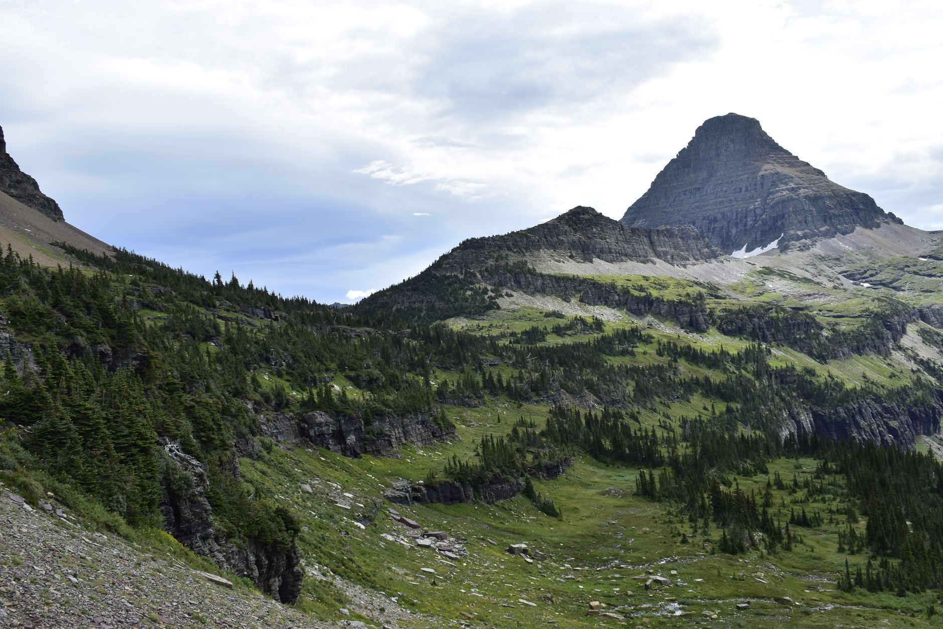
The Highline starts directly across the road from the Logan Pass visitor center at 6,646 feet, on the Continental Divide, and contours north along the Garden Wall, an arête left where glaciers ate into both sides of the same ridge.
The classic outing is point-to-point to The Loop, roughly 11.8 miles, and the profile is unusual and welcome, because after the initial traverse it is predominantly downhill, dropping to the switchback on Going-to-the-Sun Road where the shuttle picks you up. Since you finish somewhere different from where you started, this hike depends entirely on transport, which is the thing to sort before anything else.
You can also treat it as an out-and-back of any length. The first two to three miles contain the cable section and most of the drama, and turning around there is a perfectly good half day.
The Highline Trail Hike from Logan PassThe cable, honestly
About a third of a mile in, the trail traverses a cliff face on the flank of the Garden Wall, with a hand cable bolted into the rock for roughly a quarter mile.
What it is like: the trail is a cut ledge, several feet wide, with solid footing, the drop on the outside is real and it is long, and the cable sits at hip to shoulder height and gives you something to hold. What it is not: technical, or narrow enough to require care with foot placement, or exposed in the way a scramble is.
Anyone with a genuine problem with heights will find it difficult, because the exposure is sustained for a few minutes and there is no way to avoid looking at it. If that describes you, this is a real consideration and the honest answer may be to do a different hike in the park. Everyone else will be through it quickly and slightly disappointed that the famous bit was so brief.
It is worse in wet or icy conditions, and early-season snow across the traverse is a genuine hazard rather than an inconvenience, which is one of the reasons the trail opens late.
2026: the rules changed in your favor and against you
This is the section that matters most for planning, because Glacier's access system is different this year from recent seasons.
There are no vehicle reservations anywhere in the park in 2026, since the Park Service eliminated them park-wide across Going-to-the-Sun Road, Many Glacier, Two Medicine and the North Fork, so you need a valid park entrance pass and nothing more to drive in. That removes what had been the single biggest planning obstacle.
But the shuttles are reservation-only. The Going-to-the-Sun Road shuttles to Logan Pass run on a reservation system, with a portion of tickets released 60 days ahead beginning May 2 at 8am MDT on a rolling basis and the remainder at 7pm MDT for next-day travel beginning June 30, through Recreation.gov or by phone, first come first served. And from July 1, private vehicle parking at Logan Pass is limited to three hours.
That last rule is the one that reshapes this hike, because an 11.8-mile point-to-point cannot be done inside a three-hour parking window. From July onward you either use the shuttle in at least one direction, or you gamble on the cap not being enforced as you understand it, which is not a plan worth relying on. The practical answer for most people is to book a shuttle ticket, ride to Logan Pass, hike to The Loop, and shuttle back to the car, which means planning 60 days out or catching the 7pm next-day release.
It is an unusual situation and worth naming plainly: this is a trail whose feasibility is decided by a parking regulation rather than by anything on the ground. Guidepole Hike carries trailhead rules of exactly that kind, including parking limits and shuttle requirements, alongside the route, because a three-hour cap is not something the trail itself will ever tell you about. These rules also change annually, so confirm with Glacier National Park before planning around any of it.
When it is even open
Glacier has one of the shortest seasons of any major American park. The full 50 miles of Going-to-the-Sun Road typically opens between late June and early July depending entirely on snowpack, because crews plow the Big Drift near Logan Pass through the spring.
The Highline itself opens later than the road in most years, since the cable traverse and the higher sections hold snow after the road is driveable, and early-season snow on that ledge is exactly the hazard the cable does not solve. Shuttles run roughly July through September, weather permitting.
September is the best month if you can choose: cooler, quieter after Labor Day, larches turning at the end of it, and the light at its best, though facilities start closing early in the month.
Doing it as an out-and-back instead
Given that the point-to-point now depends entirely on shuttle logistics, the out-and-back deserves proper consideration rather than being treated as a fallback.
Two to three miles out and back gives you the cable traverse, the best of the Garden Wall scenery and the sense of the place, in a half day that fits comfortably inside the three-hour Logan Pass parking cap, and for a lot of visitors this is the correct version of the Highline. Out to Haystack Butte and back, roughly seven miles round trip, extends that into a full day with more of the traverse and generally fewer people the further you go. And out to Granite Park Chalet and back is a long day at around fifteen miles, removing the shuttle problem entirely at the cost of walking the whole thing twice.
The first mile is the most crowded stretch of trail in the park on a July morning. It thins noticeably by mile three and dramatically by mile five, which is the general rule for this park and worth knowing.
What to Watch Before Hiking the Highline TrailThe optional extras
Two detours are worth knowing about. The Grinnell Glacier Overlook is a steep spur climbing roughly 900 feet from the Highline to a saddle on the Garden Wall, looking down on Grinnell Glacier and Upper Grinnell Lake in the Many Glacier valley on the far side. It adds serious effort to an already long day and it is one of the best views in the park.
Granite Park Chalet, a backcountry chalet reached at around 7.6 miles, is a historic stone building offering shelter, water and a place to sit, operating seasonally with bookings going far ahead. From the chalet the trail descends to The Loop, and that descent is the least interesting part of the day: switchbacks through a burn from a previous fire, hot and exposed in the afternoon.
Wildlife, and why bear spray is standard
The Highline runs through prime habitat and the encounters are part of the experience. Mountain goats and bighorn sheep are common along the Garden Wall, often close to the trail and entirely unbothered by people, and goats are drawn to salt and will approach packs and follow hikers, so give them room and do not let them get to your gear.
Grizzlies are present throughout, because Glacier has one of the densest populations in the lower 48 and the Highline crosses open slopes and brush where sightlines vary. Carry bear spray on your body rather than in the pack, on a hip belt or chest strap where you can reach it in two seconds, and since it cannot be flown with, buy or rent in West Glacier or St. Mary. Make noise on blind corners, and check the park's alerts page, because sections close for bear activity at short notice.
This is ordinary practice here rather than an abundance of caution.
What you are walking along
The Garden Wall is worth understanding, because it explains the shape of the whole hike. It is an arête, a knife-edged ridge left behind where two glaciers ate into opposite sides of the same wall of rock, grinding it thinner from both directions until only a fin remained. The Highline contours along its western flank while Grinnell Glacier sits on the eastern side, which is why the overlook spur exists and why it is such a dramatic thing to reach.
The rock itself is unusual. Most of Glacier is ancient sedimentary strata, meaning mudstone, limestone and argillite laid down over a billion years ago and then shoved eastward along the Lewis Overthrust, a fault that pushed a vast slab of very old rock up and over much younger rock. The horizontal red, green and gray banding visible in the cliffs above the trail is those layers, with the colors coming from iron in the argillite oxidizing differently depending on exposure to air.
So the trail is a cut ledge along a glacially carved fin of billion-year-old seabed, which is a reasonable thing to think about while walking it.
The gear
The Highline is a ledge trail along the Continental Divide starting at Logan Pass, and the two most important items on the list are about bears and about transport.
Bear spray on a hip belt, not in a pack. This trail runs through prime grizzly habitat for its whole length, the ledge sections mean you cannot leave the trail, and the park treats spray as standard equipment here rather than as a precaution.
A shuttle reservation, or a plan that does not need one, which is the logistical crux. The classic version of this hike is one-way from Logan Pass down to The Loop, which means you finish eight miles by road from your car and depend on the shuttle. Logan Pass parking also fills before seven in the morning.
An insulating layer and a windshell, since you are walking at around seven thousand feet along an exposed divide where the wind is constant.
Two to three liters of water plus a filter.
Trekking poles, for the long descent from Granite Park down to The Loop, which drops twenty-two hundred feet.
Binoculars, for the goats and bighorns that are routine along the ledge and for the bears on the slopes across the valley.
And a rain shell, because weather crosses the divide fast and the ledge is not a place to be caught cold.
Where to stay, and what to carry
The Highline is reachable from both sides of the park and the choice affects the day considerably. West Glacier and Apgar form the busiest entrance and the closest to the shuttle system's western end, with the most services, though from there Logan Pass is a long, slow, spectacular drive up the Sun Road. St. Mary on the east side is closer to Logan Pass and considerably quieter, and the east side generally has better weather, because the Divide catches the moisture and the eastern slope sits in its rain shadow. Lake McDonald Lodge sits partway along the road on the west side and is the classic in-park option.
Whichever side you pick, the drive is not fast. Going-to-the-Sun Road is 50 miles of narrow, winding, spectacular road with frequent stops, and treating it as a commute is a mistake, though so is underestimating how long it takes when you have a shuttle to catch. Note also that The Loop parking is small and functions as a shuttle stop rather than a good place to leave a car all day.
As for what goes in the pack: there is no potable water along the route, so carry two to three liters and filter what you find. The traverse is exposed to weather as well as to drops, afternoon storms build over the Divide with little warning, and there is no shelter for most of the route. Layers matter, because Logan Pass at 6,646 feet on the Continental Divide is cold and windy even in July. Dogs are not permitted, as on all Glacier trails. And signal is absent across the whole corridor.
Sort the transport first
Sort the transport first, because in 2026 a three-hour parking cap at Logan Pass makes the point-to-point impossible without a shuttle, and the shuttle needs booking 60 days out or catching the 7pm next-day release.
Go in September if you can choose. Carry bear spray where you can reach it. Take layers for the Divide and water for the whole day.
And do not spend much time worrying about the cable. It is four minutes of hip-height steel on a wide ledge, and the photograph makes it look like something it is not.
The park's other marquee hike sits in a separate valley entirely, Grinnell Glacier, and if you have a single day to allocate, one day in Glacier covers the choice. On the bears, which are not optional here: hiking in bear country.
The park's other signature walk, and the one with the ice at the end of it, is in the Grinnell Glacier trail. The one-day framing of the whole park is in one day in Glacier National Park. The rest of Montana's hiking is in Bitterroot canyon hiking, hiking Missoula and hiking Bozeman.